Weir (Water Overlay): Difference between revisions
Jump to navigation
Jump to search
No edit summary |
No edit summary |
||
| Line 33: | Line 33: | ||
* [[Weir dam surplus height m (Water Overlay)]] | * [[Weir dam surplus height m (Water Overlay)]] | ||
* [[Weir dam output (Water Overlay)]] | * [[Weir dam output (Water Overlay)]] | ||
|api= | |||
* [[Api session event editor overlay set key value]] | |||
* [[Api session event editor building set attribute]] | |||
* [[Api session event editor functionoverride set attribute]] | |||
}} | }} | ||
{{WaterOverlay hydraulic structure nav}} | {{WaterOverlay hydraulic structure nav}} | ||
Latest revision as of 14:01, 15 July 2026
Weirs act as small dams that allow water to flow from higher to lower water levels. Any water exceeding the height of the weir can flow over it, increasing the throughput as the water level increases. Strictly, water can flow over the weir in either direction.
 A weir is a line-based building.
| Icon | Key | Unit | Range | Description | Default value |
|---|---|---|---|---|---|
 |
WEIR_HEIGHT | m + datum | -10000 to 10000 | The height of the weir. Water can flow past the weir when the water level exceeds the weir's height. | n/a |
 |
WEIR_WIDTH | m | 0 to 10000 | The width of the weir. | 5 |
 |
WEIR_ANGLE | geo angle (0-360°) | -1.7976931348623157E308 to 1.7976931348623157E308 | The top down orientation angle of the weir. | 0 |
 |
WEIR_COEFFICIENT | coefficient | 0 to 10000 | The flow coefficient related to the shape of the weir. | 1.1 |
 |
WEIR_N | exponent | 0 to 3.4028235E38 | Weir shape exponent | 1.5 |
 |
WEIR_TARGET_LEVEL | m + datum | -10000 to 10000 | The Weir can be configured to adjust it's height automatically in order to reach the target upstream water level. This parameter is optional. | n/a |
Notes
- If a weir is placed in a waterway, and the waterway is not otherwise interrupted, water might be able to flow past the weir via the waterway itself. In order to obstruct the waterway, one of two options can be chosen:
- Define the weir angle, in which case the Tygron Platform will automatically raise the DEM in the simulation based on the position, width and angle of the weir.
- Manually raise the terrain height using the terrain height tool or applying a terrain height GeoTIFF.
- Weirs can be imported as points. The Rasterization and Water Module will always position a weir using its center-point, and orient its flow direction using the optional weir angle. The elevation is raised along the line perpendicular to the flow direction, up to the calculated dam width of the weir.
-
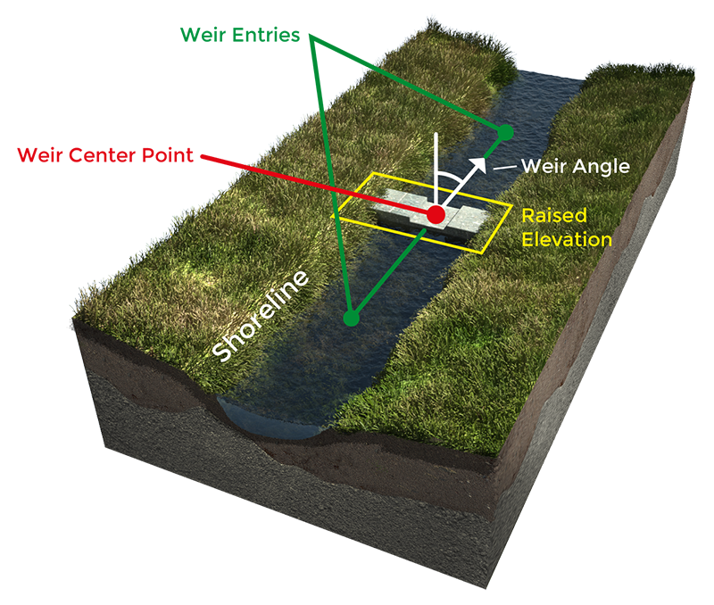 Weir placed along a waterway. Elevation is raised along the line perpendicular to the weir angle.
 -
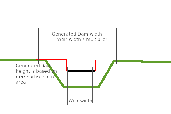 Perpendicular view of a Weir and the calculated calculated dam width.
.png)

How-to's
- How to correct multiple buildings on the same location
- How to correct weir or pump or culvert drawn as point
- How to correct a building in an uninterrupted waterway
- How to correct a building at the edge of the project area
See also
- Weir formula (Water Overlay)
- Weir height test case (Water Module)
- Weir dam multiplier (Water Overlay)
- Weir dam surplus height m (Water Overlay)
- Weir dam output (Water Overlay)



