How to correct a building in an uninterrupted waterway
The Water Overlay models a number of Buildings as line-based buildings, which allow water to flow through the structure from one endpoint to the other. However, some Buildings also naturally inhibit water flowing past them in an otherwise uninterrupted waterway. For example, a weir is effectively a small dam in a waterway. In source data, these Buildings may appear in an uninterrupted waterway. In Tygron Platform, a blockage must be added to ensure water flows only through the Building.
A Building with an angle automatically has a blockage added perpendicular to the direction of flow. For that reason, it is recommended to add an angle to a building where possible. In these situations, the generated blockage is also visualized by the Water Overlay.
If adding an angle is not possible, the waterway interruption can be added manually.
Adding a height modifying feature
To create an interrupted waterway without irrevocably modifying the elevation model, the breach feature can be employed. The Breach functionality includes modifying the elevation model in the location of the Breach. Usually this is used to lower the height of the terrain, but it can also be used to increase it. Breaches store height modifications separately, allowing them to be edited or removed without permanently altering the original elevation model.
- Find the Building in the uninterrupted waterway in the Editor.
- Click on the terrain just beside the waterway, and determine the height of the terrain relative to datum.
- Add a new Area to the Project.
- Draw the polygon of the Area in the location where the waterway should be interrupted.
- Add a BREACH_HEIGHT Attribute to the Area.
- Set the value of the Attribute to the previously determined terrain height.
- After recalculating the Overlay, the effects of the changed terrain height have been taken into account.
-
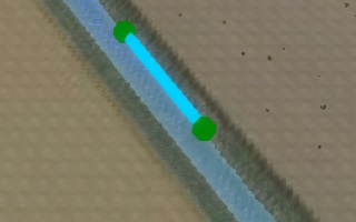 A weir in a waterway.
 -
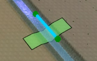 Draw a breach across the waterway. Set the breach height to the surrounding terrain height.
 -
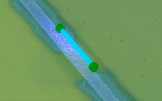 The computed surface elevation now forms an interruption in the waterway.


Directly modifying the heightmap
It is also possible to directly modify the terrain height map. This prevents adding unnecessary project data that may not align with the feature's semantic meaning.
- Find the Building in the uninterrupted waterway in the Editor.
- Click on the terrain just beside the waterway, and determine the height of the terrain relative to datum.
- Opt to change the terrain elevation in the Terrain dropdown.
- Make a selection perpendicular to the flow direction, with the height set to the previously determined terrain height.
- Apply the change. The waterway will now be interrupted.
- After recalculating the Overlay, the effects of the changed terrain height have been taken into account.
-
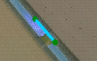
A weir in a waterway.
-
Modify the elevation in the middle of the waterway. Raise it to height of the surrounding terrain.
-
 The waterway is now interrupted.
