Breach (Water Overlay): Difference between revisions
Jump to navigation
Jump to search
(→Notes) |
|||
| Line 38: | Line 38: | ||
* The [[Base_types_result_type_(Water_Overlay)|Base Types Result]] child overlay can be used to see which part of entire the breach area is considered "active". Breach growth can be seen when checking multiple timeframes. | * The [[Base_types_result_type_(Water_Overlay)|Base Types Result]] child overlay can be used to see which part of entire the breach area is considered "active". Breach growth can be seen when checking multiple timeframes. | ||
* You can also optionally change the default breach weir coefficient to model energy loss by adding a [[Weir_coefficient_(Water_Overlay)|WEIR_COEFFICIENT]] attribute to the Breach area. | |||
Revision as of 12:19, 2 September 2022
A Breach area can be used to simulate a breach in a levee.
Overview
A breach area can be defined via the BREACH_HEIGHT attribute. It can have an input area or external area with a water body outside of the hydrological model. Water can flow through the breach form the input into the breach area just behind the levee and vise versa.
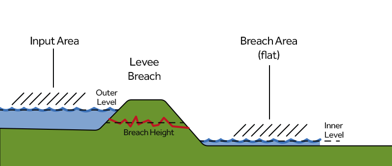
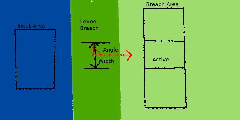
The breach is simulated as a generic weir with breach characteristics that models the energy loss, the weir input/output is dynamically mapped onto the 2D grid cells. Using the Verheij–van der Knaap method the breach can also grow over time. Below a simple schematic of the breach elements.
Top Down
Side View
Features
- The breach can grow over time, based on its initial width, critical speed and inner and outer water level, for more details see Breach growth formula.
- Instead of using an input area you can also define a fictitious external area, this can represent a larger water body outside the project area, e.g. the entire sea. The external area also has it's own Surface level, Water level and Area.
- If a BREACH_WIDTH attribute is defined, the breach's polygon is intersected with a circle emanating from the center-point of the polygon. It is only in that intersection, called "active", that water will flow in from the input area. The radius of the circle defining the intersection will expand as the breach grows over time.
- Water flowing through the breach will flow in the direction defined by the BREACH_ANGLE attribute, regardless of whether the water flowed onto the breach from elsewhere in the water model, or from the simulated external water body. When no BREACH_ANGLE is defined, water can flow in any direction. Adding this attribute with also convert the breach advection speed (m/s) into the 2D cell of the breach area. It is recommended to always use this attribute for optimal flow.
- If no BREACH_SPEED attribute is defined, the active breach will never grow. If no width is defined, the width is assumed to be very large, creating an intersection exactly the size of the polygon.
- The BREACH_HEIGHT attribute can also have multiple values over time, this allows you this simulate the breach vertical growth.
Notes
- The elevation map covered by the entire breach area is adjusted to at least the minimum height defined by its BREACH_HEIGHT attribute. This is to prevent the terrain height from interfering with the flow.
- When using breach growth the inner water level is computed from the average value in the active breach area. For optimal flow simulation it is therefor recommended to place the breach area just behind the levee on a flat space.
- Water on a breach area is automatically spread across the entire active breach area equally.
- The inner and outer water levels are visualized per timeframe on the breach object in the 3D map, these can be very useful to see how the breach is progressing.
- The Base Types Result child overlay can be used to see which part of entire the breach area is considered "active". Breach growth can be seen when checking multiple timeframes.
- You can also optionally change the default breach weir coefficient to model energy loss by adding a WEIR_COEFFICIENT attribute to the Breach area.
| Icon | Key | Unit | Range | Description | Default value |
|---|---|---|---|---|---|
| |
BREACH_HEIGHT | m + datum | The new terrain height at the location of the breach. | n/a | |
| |
BREACH_WIDTH | m | The initial width of the breach. | 10000 | |
| |
BREACH_ANGLE | geo angle (0-360°) | -1.7976931348623157E308 to 1.7976931348623157E308 | The angle at which water flows out through the breach. | n/a |
| |
BREACH_SPEED | m/s | The critical speed factor in the breach width grow-formula (e.g. 0.2 for sand and 0.5 for clay). | n/a | |
| |
BREACH_INPUT_AREA | ID of an Area | The Area item representing the influx area for the breach. | none | |
| |
EXTERNAL_SURFACE_LEVEL | m + datum | The height of the bottom of the external water body behind the breach. The lowest level the external water level can lower to. | 0 | |
| |
EXTERNAL_WATER_LEVEL | m + datum | The water level of the external water body behind the breach. The initial level the water level is set to. | 0 | |
| |
EXTERNAL_AREA | m² | The surface area of the external water body behind the breach. The larger the external water body, the more water can flow from it (or into it), and the smaller the effect of the inflow or outflow of water on the external water level. When provided with a second value, this key will also define a bottom area for the external water body, transforming its cross-section from a rectangle to a trapezoid. | n/a |
How-to's
- How to add a breach with external area manually
- How to add a breach with input area manually
- How to import a breach with input area
- How to set dynamic breach height
- How to visualize multiple sequential breaches (Water Overlay)


