Object datum output a (Water Overlay): Difference between revisions
Jump to navigation
Jump to search

No edit summary |
No edit summary |
||
| (5 intermediate revisions by the same user not shown) | |||
| Line 6: | Line 6: | ||
|defaultvalue=None | |defaultvalue=None | ||
|icon= | |icon= | ||
|range=-{{max surface}} to {{max surface}} | |||
}}</onlyinclude>}} | }}</onlyinclude>}} | ||
| Line 17: | Line 18: | ||
* This attribute is also visible when zoomed in on a [[Hydraulic_structures_(Water_Overlay)|hydraulic structure]]. The [[Water_level_(Water_Overlay)|water level]]s on either side of the structure can be seen at each timeframe when a [[Water Overlay]] is selected. | * This attribute is also visible when zoomed in on a [[Hydraulic_structures_(Water_Overlay)|hydraulic structure]]. The [[Water_level_(Water_Overlay)|water level]]s on either side of the structure can be seen at each timeframe when a [[Water Overlay]] is selected. | ||
|howtos= | |howtos= | ||
* [[How to export | * [[How to inspect object output attributes of an overlay using the measurement tool]] | ||
* [[How to export an Object output attribute as measurement]] | |||
|seealso= | |seealso= | ||
* [[Hydraulic_structures_(Water_Overlay)|Hydraulic structures]] | * [[Hydraulic_structures_(Water_Overlay)|Hydraulic structures]] | ||
* [[Water_level_(Water_Overlay)|Water level]] | * [[Water_level_(Water_Overlay)|Water level]] | ||
*[[Weir | * [[Weir height test case (Water Module)|Weir flow test case]] | ||
}} | }} | ||
{{WaterOverlay hydraulic structure nav}} | {{WaterOverlay hydraulic structure nav}} | ||
{{WaterOverlay output nav}} | |||
Latest revision as of 08:53, 27 February 2024
| Icon | Key | Unit | Range | Description | Default value |
|---|---|---|---|---|---|
| OBJECT_DATUM_OUTPUT_A | m + datum | -10000 to 10000 | An array of values, one per timeframe. Each value indicates the water level at one side of the hydraulic structures, generally the entry. | None |
All hydraulic structures have an OBJECT_DATUM_OUTPUT_A attribute.

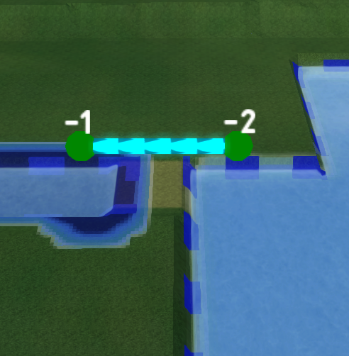
A weir showing the datum heights at that timeframe, obtained from the values of the OBJECT_DATUM_OUTPUT_A and OBJECT_DATUM_OUTPUT_B key stored in that weir.
Notes
- This attribute does not need to be created when configuring the project. This attribute is created automatically by the Water Overlay when a calculation is performed. When the calculation is complete, the attribute is updated automatically.
- Each Water Overlay will create this attribute with the ID of an Overlay appended to it, to prevent the results of multiple Water Overlays storing their results in the same attribute by default.
- This attribute is also visible when zoomed in on a hydraulic structure. The water levels on either side of the structure can be seen at each timeframe when a Water Overlay is selected.
How-to's
- How to inspect object output attributes of an overlay using the measurement tool
- How to export an Object output attribute as measurement


