Flooding Overlay: Difference between revisions
No edit summary |
(→Module) |
||
| (164 intermediate revisions by 7 users not shown) | |||
| Line 1: | Line 1: | ||
[[File:FloodingOverlay2.png|right|thumb|200px|Flooding overlay]] | |||
The | The Flooding Overlay is a variant of the [[Water Overlay]], which in turn is a [[Grid overlay|grid overlay]]. Water overlays are connected to the [[Water Module]], a complex hydrological calculation module within the {{software}}. | ||
The Flooding Overlay calculates and visualizes the movement of water over land, due to a [[Breach_(Water_Overlay)|breach]] or other [[Inlet_(Water_Overlay)|inflow]] of water in the project area. | |||
[[ | In order to get more familiar with the different components of the Flooding Overlay check out Quadrant 1 of the [[Testbed_water_module|Water Module Testbed]]. This Testbed is available to you as a project in the {{software}}. | ||
== | ==Flooding overlay results== | ||
The | The Flooding Overlay is a Water Overlay that is connected to the Water Module. This Water Module performs two dimensional grid based water simulations for a large set of input data and parameters, configured mostly through a related [[Water_Overlay_Wizard|Water Overlay Wizard]]. When a simulation finishes, the module stores the result in the Flooding overlay based on the selected result type. Only one result type can be stored per Flooding overlay. | ||
|Water | |||
The Water Module however, is not restricted to generating only one type of result. Instead it can produce multiple unique result types for one single simulation. | |||
Fortunately it is possible to add additional result type overlays which relate to a particular Rainfall overlay. These are known as [[Result Child Overlay]]s. Again, each child overlay only stores one particular result type. | |||
Apart from multiple result types, the Flooding overlay can also store result data of multiple, intermediate simulation results, instead of just a single end result. These intermediate simulation results are known as [[Timeframes_(Water_Overlay)|timeframes]]. | |||
For the full list of result types, see [[Result type (Water Overlay)#List of Result Types|List of Result Types]]. | |||
For other results, which are not overlay results, but still related to the simulation of a Flooding overlay, see [[Results (Water Overlay)|water overlay results]] | |||
==Module== | |||
A Flooding Overlay can be configured by opening the Flooding Overlay Wizard. More in-depth information can be found under each of the categories below. | |||
{{Water Module buttons}} | |||
{{WaterOverlay output nav}} | |||
{{Overlay nav}} | |||
Latest revision as of 13:46, 17 January 2023
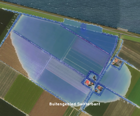
The Flooding Overlay is a variant of the Water Overlay, which in turn is a grid overlay. Water overlays are connected to the Water Module, a complex hydrological calculation module within the Tygron Platform.
The Flooding Overlay calculates and visualizes the movement of water over land, due to a breach or other inflow of water in the project area.
In order to get more familiar with the different components of the Flooding Overlay check out Quadrant 1 of the Water Module Testbed. This Testbed is available to you as a project in the Tygron Platform.
Flooding overlay results
The Flooding Overlay is a Water Overlay that is connected to the Water Module. This Water Module performs two dimensional grid based water simulations for a large set of input data and parameters, configured mostly through a related Water Overlay Wizard. When a simulation finishes, the module stores the result in the Flooding overlay based on the selected result type. Only one result type can be stored per Flooding overlay.
The Water Module however, is not restricted to generating only one type of result. Instead it can produce multiple unique result types for one single simulation. Fortunately it is possible to add additional result type overlays which relate to a particular Rainfall overlay. These are known as Result Child Overlays. Again, each child overlay only stores one particular result type.
Apart from multiple result types, the Flooding overlay can also store result data of multiple, intermediate simulation results, instead of just a single end result. These intermediate simulation results are known as timeframes.
For the full list of result types, see List of Result Types. For other results, which are not overlay results, but still related to the simulation of a Flooding overlay, see water overlay results
Module
A Flooding Overlay can be configured by opening the Flooding Overlay Wizard. More in-depth information can be found under each of the categories below.


