Subsidence Overlay: Difference between revisions
No edit summary |
|||
| Line 8: | Line 8: | ||
[[File:Subsidence-Overlay.jpg|thumb|200px|left|The subsidence overlay]] | [[File:Subsidence-Overlay.jpg|thumb|200px|left|The subsidence overlay]] | ||
[[File:Groundwater-Overlay.jpg|thumb|200px|left|The ground water overlay]] | [[File:Groundwater-Overlay.jpg|thumb|200px|left|The ground water overlay]] | ||
The Subsidence Overlay is an [[Grid overlay|overlay]] that shows which places in the [[3D world]] are subject to subsidence due to oxidation and/or compaction of peat. The [[subsidence calulation|calculations]] can give result about the subsidence, and the effects it has on | The Subsidence Overlay is an [[Grid overlay|overlay]] that shows which places in the [[3D world]] are subject to subsidence due to oxidation and/or compaction of peat. The [[subsidence calulation|calculations]] can give result about the subsidence, and the effects it has on groundwater levels. To add a subsidence overlay go to Geo Data -> Overlays -> Add Subsidence. | ||
The Subsidence Overlay can be used to calculate the amount of subsidence which takes place on peat soil, specifically due to peat oxidation and compaction. The calculations are specific for peat soil. Separate formulas for other soil types have not yet been implemented. Although it's possible to use the overlay to give an impression of subsidence resulting from other factors, the results will be less accurate. This means that results have a greater margin of error for different use-cases. | The Subsidence Overlay can be used to calculate the amount of subsidence which takes place on peat soil, specifically due to peat oxidation and compaction. The calculations are specific for peat soil. Separate formulas for other soil types have not yet been implemented. Although it's possible to use the overlay to give an impression of subsidence resulting from other factors, the results will be less accurate. This means that results have a greater margin of error for different use-cases. | ||
| Line 24: | Line 24: | ||
For information on the exact calculation of subsidence due to oxidation, see the article on [[Subsidence calculation#Oxidation Calculation|Subsidence calculation (section on Oxidation)]]. | For information on the exact calculation of subsidence due to oxidation, see the article on [[Subsidence calculation#Oxidation Calculation|Subsidence calculation (section on Oxidation)]]. | ||
==== | ====Groundwater levels==== | ||
Groundwater levels strongly affect how much peat can oxidize. Groundwater levels, in turn, are affected by surface water levels, which can be changed during a session. Based on changes in surface water level, the groundwater level changes as well. | |||
For information on the exact calculation of | For information on the exact calculation of groundwater level changes, see the article on [[Subsidence calculation#Ground Water change calculation|Subsidence Calculation (section on Ground Water )]]. | ||
===Compaction=== | ===Compaction=== | ||
| Line 39: | Line 39: | ||
===Loss of earnings of crops=== | ===Loss of earnings of crops=== | ||
The loss of earnings of crops can now be added as result types. The loss of earnings is divided into 4 categories; indirect damage, damage due to wetness, damage due to drought and damage due to irrigation with salinated water. The computations are done by the [https://waterwijzerlandbouw.wur.nl/ ''Waterwijzer Landbouw module''] , with which the {{software}} communicates through its API. The calculated increase or decrease of the highest and lowest | The loss of earnings of crops can now be added as result types. The loss of earnings is divided into 4 categories; indirect damage, damage due to wetness, damage due to drought and damage due to irrigation with salinated water. The computations are done by the [https://waterwijzerlandbouw.wur.nl/ ''Waterwijzer Landbouw module''] , with which the {{software}} communicates through its API. The calculated increase or decrease of the highest and lowest groundwater levels due to subsidence are taken into account before communicating the water levels to the ''Waterwijzer Landbouw module''. | ||
In short, the loss of earnings is based on: | In short, the loss of earnings is based on: | ||
| Line 46: | Line 46: | ||
* Weather station; The selectable dutch weather stations are: De Bilt, De Kooy, Eelde, Vlissingen and Maastricht. | * Weather station; The selectable dutch weather stations are: De Bilt, De Kooy, Eelde, Vlissingen and Maastricht. | ||
* Climate scenario; Only one of two can be selected: Current situation (1981-2010) and WH 2050 (2036-2065) | * Climate scenario; Only one of two can be selected: Current situation (1981-2010) and WH 2050 (2036-2065) | ||
* The adjusted highest and lowest | * The adjusted highest and lowest groundwater level: These are provided by the Subsidence calculations described in the sections above. | ||
* Irrigation and salinity: these are currently set to 0 and not adjustable in the {{software}}. | * Irrigation and salinity: these are currently set to 0 and not adjustable in the {{software}}. | ||
--> | --> | ||
| Line 99: | Line 99: | ||
* The [[subsidence calculation#Indexation|indexation]] policy currently configured for this water level area. | * The [[subsidence calculation#Indexation|indexation]] policy currently configured for this water level area. | ||
=== | ===Groundwater level output=== | ||
The output of the [[grid overlay|grid]] of each groundwater result type is the final distance from the groundwater level to the surface of the land in meters. | The output of the [[grid overlay|grid]] of each groundwater result type is the final distance from the groundwater level to the surface of the land in meters. | ||
| Line 112: | Line 112: | ||
===Oxidation=== | ===Oxidation=== | ||
Oxidation is affected by changes in the (ground) water level. During a session, if the WATER_LEVEL attribute is changed, the | Oxidation is affected by changes in the (ground) water level. During a session, if the WATER_LEVEL attribute is changed, the groundwater level is adjusted as well. This in turn leads to more or less subsidence through oxidation. The groundwater level can also be affected by the user creating drainage. These are [[construction]]s with a "drainage" [[function value]]. Drainage sets the groundwater level to an artificial height, affecting the amount of oxidation taking place. | ||
===Compaction=== | ===Compaction=== | ||
| Line 126: | Line 126: | ||
====Areas==== | ====Areas==== | ||
In 3 steps, some geographical information will be configured, related to surface- and | In 3 steps, some geographical information will be configured, related to surface- and groundwater. Options presented allow for importing data, or generating some parameters based on general assumptions. | ||
====Constructions==== | ====Constructions==== | ||
| Line 146: | Line 146: | ||
The calculation will only work when the [[terrain]] is sensitive to subsidence. By default, [[peat]] is the only terrain sensitive to subsidence. If your project does not yet have a peat soil, you can either set a different soil type to be sensitive to subsidence, or add peat to your project. | The calculation will only work when the [[terrain]] is sensitive to subsidence. By default, [[peat]] is the only terrain sensitive to subsidence. If your project does not yet have a peat soil, you can either set a different soil type to be sensitive to subsidence, or add peat to your project. | ||
''Note that | ''Note that groundwater levels are calculated for any kind of soil, not just soil that is sensitive to subsidence. This means this step kan be skipped if you're using the groundwater level result types(s).'' | ||
{{Editor location|Terrain}} | {{Editor location|Terrain}} | ||
| Line 173: | Line 173: | ||
It's possible to configure the overlay further with additional data. | It's possible to configure the overlay further with additional data. | ||
===== | =====Groundwater levels===== | ||
By default, the | By default, the groundwater levels are loaded in from a publicly available geotiff automatically. Under the "Keys" tab in the [[right panel]], you can change the selected geotiff by selecting a different one at "Include Ground Water Tiff". You can also disable the groundwater geotiff, and use a groundwater level attribute of areas instead. | ||
{{Editor steps|title=add your own | {{Editor steps|title=add your own groundwater data|Select the overlay|In the [[right panel]], select the "keys" tab|Uncheck the "Include Ground Water Tiff" checkbox|Select or create an area, part of the [[3D world]]|Add the attribute "GLG" to the area, with a value of, for example, "-1"}} | ||
=====Clay thickness===== | =====Clay thickness===== | ||
Revision as of 14:34, 3 September 2020


Result types
The overlay offers the following result types:
| Result type | Unit | Description |
|---|---|---|
| SUBSIDENCE | m change in land height | The amount that the ground has lowered as a result of subsidence, both oxidation and compaction. A positive number means the ground has lowered. |
| OXIDATION | m change in land height | The amount that the ground has lowered as a result of peat oxidation. |
| SETTLEMENT | m change in land height | The amount that the ground has lowered as a result of compaction. |
| HI_GROUND_WATER | m distance from surface to groundwater | The distance between the ground surface and the highest groundwater level. This number is lower than that of the lowest groundwater level. A positive value means the groundwater is below the surface of the land. A negative value would theoretically mean the groundwater has risen above the surface of the ground. |
| LOW_GROUND_WATER | m distance from surface to groundwater | The distance between the ground surface and the lowest groundwater level. This number is higher than that of the highest groundwater level. A positive value means the groundwater is below the surface of the land. A negative value would theoretically mean the groundwater has risen above the surface of the ground. |
Legend
The legend of the subsidence overlays is automatically calculated, based on the amount of years being calculated by the overlay. The colors will remain constant based on average subsidence per year. I.e. if the amount of years is doubled, the values in the legend, corresponding to specific colors, are doubled as well. Because the legend displays total amounts of subsidence rather than averages, the displayed range of amounts changes when the amount of calculation years changes.
The legend of the groundwater overlays is constant, and will display a color from blue through yellow to red to indicate how wet the soil is. The closer the groundwater is to the surface of the land, the bluer the overlay. In contrast to the subsidence legends, the range of values for groundwater do not change.

Subsidence legend for 30 years
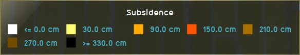
Subsidence legend for 60 years
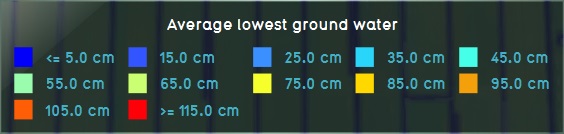
Groundwater legend


Output
The output of all result types of the overlay is in meters. The results can be exported as GeoTiff.
Subsidence output
The output of the grid of each subsidence result type is the subsidence in meters. Depending on the exact result type used, the output is the amount of subsidence as the result of one specific calculation, or the sum of all the calculations of subsidence.
The hover panel will display the following information:
- The amount of subsidence taking place over the configured amount of years.
- The current surface water level, and to what level it will have changed after the subsidence has taken place.
- The indexation policy currently configured for this water level area.
Groundwater level output
The output of the grid of each groundwater result type is the final distance from the groundwater level to the surface of the land in meters.
The hover panel will display the following information:
- The level to which the groundwater will have changed, after the subsidence has taken place.
Final water level
The overlay can also write the final surface water level to an attribute of an area. The area where the attribute will be written to is the area which has provided the original water level for the overlay.