Height sector: Difference between revisions
Jump to navigation
Jump to search
 Current Situation
mNo edit summary |
No edit summary |
||
| (18 intermediate revisions by the same user not shown) | |||
| Line 1: | Line 1: | ||
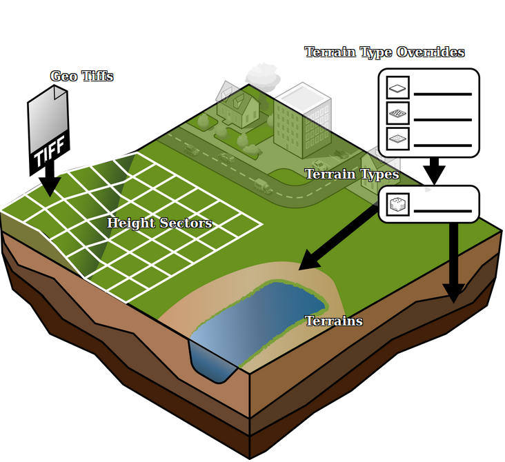
[[File:Api_current_situation_geography.png|thumb|right|400px|[[Height sector]]s in relation to [[Terrain]]s and [[Elevation GeoTIFF]]s.]] | |||
A height sector is a data item which store the height data of the [[Elevation model]]. Each height sector is a square tile of 500m x 500m. Height values are stored in meters with a precision of 3 decimals. The amount of points per height sector depend on the DEM resolution configured in advanced options of the [[New Project Wizard]], before project creation, and cannot be increased or decreased later on. | |||
Height sectors are not directly accessed in the editor, but can be manipulated indirectly using the [[terrain height brush]] or by applying [[Elevation GeoTIFF]]s. | |||
===Heightmap Option=== | |||
The Heightmap option is stored as an enumeration in the [[Geo Option]] '''HEIGHTMAP_RESOLUTION'''. | |||
{|class=wikitable | |||
! Enum | |||
! Point distance (meter) | |||
! Height points per sector | |||
|- | |||
|SUPER | |||
|0.25 | |||
|2000 x 2000 points | |||
|- | |||
|HIGH | |||
|0.5 | |||
|1000 x 1000 points | |||
|- | |||
|NORMAL | |||
|1.0 | |||
|500 x 500 points | |||
|- | |||
|LOW | |||
|2.5 | |||
|200 x 200 points | |||
|- | |||
|BASIC | |||
|10.0 | |||
|50 by 50 points | |||
|} | |||
{{article end | |||
|howtos= | |||
* [[How to adjust the height map with a Combo Overlay]] | |||
* [[How to use the terrain height brush in live sculpting mode]] | |||
* [[How to use the terrain height brush in selection mode]] | |||
* [[How to change how the default elevation model is generated]] | |||
* [[How to import a GeoJSON to change the elevation model]] | |||
* [[How to import a GeoTIFF to change the elevation model]] | |||
* [[How to import a GeoJSON of waterways]] | |||
* [[How to import a GeoTIFF of waterway depths]] | |||
* [[How to export the elevation model]] | |||
* [[How to use a Grid Overlay to change the elevation model]] | |||
|seealso= | |||
* [[Elevation model]] | |||
* [[Height map]] | |||
* [[Terrain]] | |||
* [[Terrain Type]] | |||
}} | |||
{{Editor current situation nav}} | {{Editor current situation nav}} | ||
[[Category:Items]] | [[Category:Items]] | ||
Latest revision as of 14:32, 29 February 2024

A height sector is a data item which store the height data of the Elevation model. Each height sector is a square tile of 500m x 500m. Height values are stored in meters with a precision of 3 decimals. The amount of points per height sector depend on the DEM resolution configured in advanced options of the New Project Wizard, before project creation, and cannot be increased or decreased later on.
Height sectors are not directly accessed in the editor, but can be manipulated indirectly using the terrain height brush or by applying Elevation GeoTIFFs.
Heightmap Option
The Heightmap option is stored as an enumeration in the Geo Option HEIGHTMAP_RESOLUTION.
| Enum | Point distance (meter) | Height points per sector |
|---|---|---|
| SUPER | 0.25 | 2000 x 2000 points |
| HIGH | 0.5 | 1000 x 1000 points |
| NORMAL | 1.0 | 500 x 500 points |
| LOW | 2.5 | 200 x 200 points |
| BASIC | 10.0 | 50 by 50 points |
How-to's
- How to adjust the height map with a Combo Overlay
- How to use the terrain height brush in live sculpting mode
- How to use the terrain height brush in selection mode
- How to change how the default elevation model is generated
- How to import a GeoJSON to change the elevation model
- How to import a GeoTIFF to change the elevation model
- How to import a GeoJSON of waterways
- How to import a GeoTIFF of waterway depths
- How to export the elevation model
- How to use a Grid Overlay to change the elevation model
See also
- Buildings • Terrains • Administrative • Areas • Networks • Overlays • Indicators • Panels • Globals • Queries • Geo Import
- Buildings
- Function • Function Override • Traffic Units
- Terrain
- Height sector • Elevation model • Elevation GeoTIFF • Elevation Grid Overlay • Ground Price • Terrain Type • Terrain Type Override
- Administrative
- Net Cluster • Net Function • Net Line • Net Load • Net Node • Net Setting
- Editor