Digital Surface Model Overlay: Difference between revisions
Jump to navigation
Jump to search
No edit summary |
mNo edit summary |
||
| (4 intermediate revisions by one other user not shown) | |||
| Line 1: | Line 1: | ||
[[File:Example_dsm.PNG|thumb|300px|right|Example of the DSM Overlay]] | [[File:Example_dsm.PNG|thumb|300px|right|Example of the DSM Overlay]] | ||
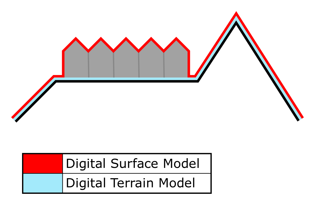
The Digital Surface Model Overlay is a [[Grid Overlay]] that displays the elevation model, the height of the terrain plus the building height. The Overlay is available to all [[Stakeholder]]s when added to a project. | The Digital Surface Model (DSM) Overlay is a [[Grid Overlay]] that displays the elevation model, the height of the terrain plus the building height. The Overlay is available to all [[Stakeholder]]s when added to a project. | ||
There exist two Heightmap Overlay types: | There exist two Heightmap Overlay types: | ||
* [[Digital Terrain Model | * [[Digital Terrain Model Overlay| Digital Terrain Model]] type: displays the height of the terrain at the selected location on the map. | ||
* Digital Surface Model type: displays the height of the terrain and the height of the building that is located on the selected location on the map. | * Digital Surface Model type: displays the height of the terrain and the height of the building that is located on the selected location on the map. | ||
For more information on how terrain height is obtained in the {{software}}, see [[elevation model]]. | For more information on how terrain height is obtained in the {{software}}, see [[elevation model]]. | ||
| Line 10: | Line 10: | ||
==Additional information displayed in hover panel== | ==Additional information displayed in hover panel== | ||
[[File:Hover_panel_heightmap_overlay_.jpg|thumb|320px|left|Digital Surface Model: Hover panel displays additional information about the height of the terrain and the | [[File:Hover_panel_heightmap_overlay_.jpg|thumb|320px|left|Digital Surface Model: Hover panel displays additional information about the height of the terrain and the building that is located on it]]<br> | ||
When clicking on a specific location on the map, the hover panel displays additional information about the height of the terrain and the | When clicking on a specific location on the map, the hover panel displays additional information about the height of the terrain and the building that is located on that specific location. | ||
<br clear=all> | <br clear=all> | ||
Latest revision as of 07:22, 5 October 2023

The Digital Surface Model (DSM) Overlay is a Grid Overlay that displays the elevation model, the height of the terrain plus the building height. The Overlay is available to all Stakeholders when added to a project.
There exist two Heightmap Overlay types:
- Digital Terrain Model type: displays the height of the terrain at the selected location on the map.
- Digital Surface Model type: displays the height of the terrain and the height of the building that is located on the selected location on the map.
For more information on how terrain height is obtained in the Tygron Platform, see elevation model.

Additional information displayed in hover panel

When clicking on a specific location on the map, the hover panel displays additional information about the height of the terrain and the building that is located on that specific location.
How-to's