Query Tool: Difference between revisions

From Tygron Support wiki
Jump to navigation Jump to search
No edit summary
No edit summary
 
(16 intermediate revisions by 4 users not shown)
Line 1: Line 1:
{{learned|file=QueryLogo-Q3-2015.jpg|what the Query Tool is|how to use the Query Tool|what you can use the Query Tool for}}
The Query Tool is a support tool in the {{software}} that aids the user by constructing data requests in the [[TQL|Tygron Query Language (TQL)]] and displaying the query output. By using this tool, the user can quickly verify if the data needed can be extracted from the project data with the available query elements. Also the tool allows for verification of the validity of the retrieved data. All this can be achieved without creating and uploading a dedicated Query Spread Sheet. See also: [[Excel (Indicator)]]


==What is the Query Tool?==
==How does the Query Tool relate to the {{software}}==
The Query Tool is a support tool in the Tygron Engine that aids the user by constructing data requests in the [[TQL|Tygron Query Language (TQL)]] and displaying the query output. By using this tool, the user can quickly verify if the data needed can be extracted from the project data with the available query elements. Also the tool allows for verification of the validity of the retrieved data. All this can be achieved without creating and uploading a dedicated Query Spread Sheet. See also: [[Excel (Indicator)]]
 
==How does the Query Tool relate to the Tygron Engine==
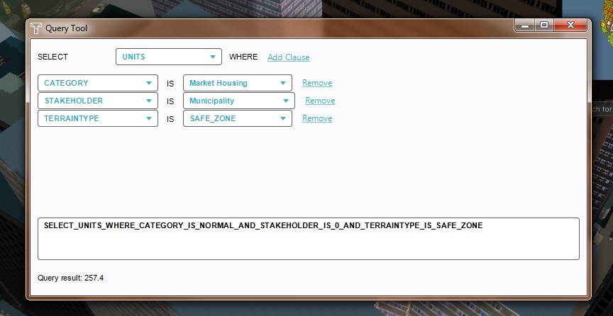
[[File:QueryToolPanel-Q3-2015.jpg|right|thumb|400px|Query Tool Panel]]
[[File:QueryToolPanel-Q3-2015.jpg|right|thumb|400px|Query Tool Panel]]


A project in the Tygron Engine can use multiple geospatial data sources. In the Netherlands the Tygron Engine uses for instance BAG and Top10NL data, while in New York the Tygron Engine uses the PLUTO data set from the NYC Municipality. Both regions use OpenStreetMaps for the placement of roads etc.
A project in the {{software}} can use multiple geospatial data sources. In the Netherlands the {{software}} uses for instance BAG and Top10NL data, while in New York the {{software}} uses the PLUTO data set from the NYC Municipality. Both regions use OpenStreetMaps for the placement of roads etc.


To retrieve all sorts of data that are present, but for which no dedicated data structure (predefined indicators) already exists, the TQL (Tygron Query Language) has been developed. By using queries with the below structure, dedicated data requests can be sent to the Tygron Engine, from which the results can then be calculated in, for instance, an Excel Indicator.
To retrieve all sorts of data that are present, but for which no dedicated data structure (predefined indicators) already exists, the TQL (Tygron Query Language) has been developed. By using queries with the below structure, dedicated data requests can be sent to the {{software}}, from which the results can then be calculated in, for instance, an Excel Indicator.


: <code>SELECT</code> [[TQL#Queries|Result Parameter]] <code>WHERE</code> [[TQL#Clauses|Clause]] <code>AND</code> [[TQL#Clauses|Clause]] <code>AND</code> [[TQL#Clauses|Clause]] <code>AND</code>... etc.
: <code>SELECT</code> [[TQL#Queries|Result Parameter]] <code>WHERE</code> [[Clause (TQL)|Clause]] <code>AND</code> [[Clause (TQL)|Clause]] <code>AND</code> [[Clause (TQL)|Clause]] <code>AND</code>... etc.


The Query Tool provides an interface in the Editor that allows for quick creation and verification of such TQL Queries.
<br clear=all>
<br clear=all>
==How to use the Query Tool in the Tygron Engine==
{{Editor ribbon|header=Tools|bar=Query Tool}}
The Query Tool can be found in the Tygron Engine Editor, under the ribbon header, in the [[Tools]] tab, by selecting the Query Tool Button. The Query Tool consists of three areas; the construction drop down menus, the actual query as a result from the construction selections and its result. It is theoretically possible to add an unlimited number of clauses. This being said, only a limited amount (of combinations) of options is available to do so.
{{Editor steps|title=use the Query Tool|Select Editor &#8594; Tools &#8594; Query Tool|Select the desired Result Parameter|Add clauses, as many as needed|Select the clause properties from the drop down menus|Notice the full query string appears in the Query field|Notice the actual Query result on the bottom of the panel}}
<gallery>
File:QueryToolRibbon-Q3-2015.jpg|1. Select Editor &#8594; Tools &#8594; Query Tool
File:QueryToolResultParameter-Q3-2015.jpg|2. Select Result parameter
File:QueryToolAddClause-Q3-2015.jpg|3. Add clauses
File:QueryToolSelectClauseProps-Q3-2015.jpg|4. Select the clause properties
File:QueryToolFullQuery-Q3-2015.jpg|5. Notice the full query string in the Query field
File:QueryToolQueryResult-Q3-2015.jpg|6. Actual Query result
</gallery>


==Uses of the Query Tool==
Line 39: Line 19:
:*The reverse is also possible, recreating a query in the tool from an Excel Indicator file, to verify if the query actually grabs data from the project area.


===Verifying available Data in a Project Area===
{{article end
: When a new project has been generated, the Query Tool can quickly check if the area contains data that can be retrieved by a Query. Doing so enables the user to quickly check the available data, without having to create a separate Excel Indicator spreadsheet with queries.
|howtos=
 
* [[How to use the Query Tool]]
: For instance, when a project area has been created with a safe zone terrain, by importing a relevant feature service from ArcGIS, the query tool can quickly verify if the safe zone data can be retrieved with a Query.
* [[How to use the Query Tool to test queries from an Excel Indicator spreadsheet]]
 
* [[How to configure a Query for an Excel Indicator]]
{{Editor steps|title=verify available data in a project area with an ArcGIS safe zone|Load or create a project with an ArcGIS safe zone|Select [[Editor]] &#8594; Tools &#8594; Query Tool|Select <code>FLOORSIZE</code> as Result Parameter|Add <code>TERRAINTYPE</code> IS <code>SAFE_ZONE</code> as clause|Verify that the Query result returns a value}}
* [[How to verify available data in a Project Area]]
<br>
|seealso=
: [[File:QueryToolVerifyData-Q3-2015.jpg|thumb|left|Verify data in project area]]
* [[TQL]]
<br clear=all>
* [[Select (TQL)]], [[Update (TQL)]] and [[Clause (TQL)]]
 
* [[Excel indicator]]s, [[Panel]]s and [[Global]]s
===Configuring a Query for an Excel Indicator===
}}
: When setting up an Excel Indicator, the Query Tool can be used to configure Queries, after which the full Query text string can be copied over to the Excel Indicator file.
 
: Looking at the above example, it is easy now to copy and paste the just created query <code>SELECT_FLOORSIZE_WHERE_TERAINTYPE_IS_SAFE_ZONE</code> into an appropriate [[Excel (Indicator)#Naming Cells|name field]] on an Excel Indicator spreadsheet.
 
{{Editor steps|title=configure a query for an Excel Indicator spreadsheet|Load or create a project with an ArcGIS safe zone|Select Editor &#8594; Tools &#8594; Query Tool|Select <code>FLOORSIZE</code> as Result Parameter|Add <code>TERRAINTYPE</code> IS <code>SAFE_ZONE</code> as clause|Copy the created Query text string, and paste this in the appropriate name field of the Excel Indicator spreadsheet}}
<br>
: [[File:QueryToolConigurefQuery-Q3-2015.jpg|thumb|left|Copy a query for pasting in an Excel Indicator spreadsheet]]
<br clear=all>
 
===Using the Query Tool to test queries from an Excel Indicator spreadsheet===
[[File:QueryErrorMessage-Q3-2015.jpg|thumb|300px|right|Query error message]]
: Another use is checking the validity of queries that were created outside the Tygron Engine. For example, consider the following query:
: <code>SELECT_FLOORSIZE_WHERE_CATEGORY_IS_OFFICES_AND_STAKEHOLDER_IS_MUNICIPALITY_AND_TERRAINTYPE_IS_SAFE_ZONE</code>


: This query seems to look good on paper, the string makes sense: Give the floor size of all municipal offices that are located in the safe zone. However, when uploading the query in a spread sheet for an Excel Indicator, the query will result in an error. If the user first attempts to recreate the query in the Tygron Engine Query Tool, he will notice that the clause <code>STAKEHOLDER_IS_MUNICIPALITY</code> is incorrect. The Tygron Engine assigns fixed numbers to stakeholders, in this case a '0'. The correct clause should read <code>STAKEHOLDER_IS_0</code>, and the full Query should be <code>SELECT_FLOORSIZE_WHERE_CATEGORY_IS_OFFICES_AND_STAKEHOLDER_IS_0_AND_TERRAINTYPE_IS_SAFE_ZONE</code>.
{{Editor_current_situation_nav}}
<br>
[[Category:TQL]]
{{Editor steps|title=use the Query Tool to test queries from an Excel Indicator spreadsheet|Create a query outside of the Tygron Engine (ex.on a spreadsheet)|Load or create a project with the project area in the Editor|Select Editor &#8594; Tools &#8594; Query Tool|Recreate the query from the spreadsheet in the Tygron Engine Query Tool|Observe if the Query from the tool matches the query created outside the Tygron Engine|Observe if the output result matches expectations}}

Latest revision as of 16:15, 1 February 2024

The Query Tool is a support tool in the Tygron Platform that aids the user by constructing data requests in the Tygron Query Language (TQL) and displaying the query output. By using this tool, the user can quickly verify if the data needed can be extracted from the project data with the available query elements. Also the tool allows for verification of the validity of the retrieved data. All this can be achieved without creating and uploading a dedicated Query Spread Sheet. See also: Excel (Indicator)

How does the Query Tool relate to the Tygron Platform

Query Tool Panel

A project in the Tygron Platform can use multiple geospatial data sources. In the Netherlands the Tygron Platform uses for instance BAG and Top10NL data, while in New York the Tygron Platform uses the PLUTO data set from the NYC Municipality. Both regions use OpenStreetMaps for the placement of roads etc.

To retrieve all sorts of data that are present, but for which no dedicated data structure (predefined indicators) already exists, the TQL (Tygron Query Language) has been developed. By using queries with the below structure, dedicated data requests can be sent to the Tygron Platform, from which the results can then be calculated in, for instance, an Excel Indicator.

SELECT Result Parameter WHERE Clause AND Clause AND Clause AND... etc.

The Query Tool provides an interface in the Editor that allows for quick creation and verification of such TQL Queries.

Uses of the Query Tool

There are a couple of main uses for the Tygron Query Tool:

  • The Query Tool can be used to verify if data is available for queries in the project area.
  • The tool can also be used to create queries, which can be copied and pasted in an Excel file to be uploaded as an Excel Indicator.
  • The reverse is also possible, recreating a query in the tool from an Excel Indicator file, to verify if the query actually grabs data from the project area.