|
|
| (103 intermediate revisions by 5 users not shown) |
| Line 1: |
Line 1: |
| [[File:zoning1.jpg|right|200px]] | | [[File:Api_current_situation_urban_subdiv.png|thumb|right|400px|[[Zone]]s in comparison to [[Area]]s, [[Neighborhood]]s and [[Plot]]s]] |
| {{learned|what zoning is in urban planning|how the concept of zoning relates to the Tygron Engine|how to add or remove zones from the 3D world|how to edit zoning already implemented in the 3D world}} | | Zones in the {{software}} are spatial areas that can restrict, and provide feedback on, [[action]]s performed by [[stakeholder]]s. Each zone is assigned to a stakeholder; that stakeholder is the ''permitter''. |
| <br clear=all>
| |
|
| |
|
| ==What is Zoning?==
| | Zones can be grouped together to form a hierarchical zoning plan, each with specific requirements to which a new action must conform. |
| : Zoning is a technique of land-use planning as a tool of urban planning used by local governments in most developed countries. The word is derived from the practice of designating mapped zones which regulate the use, form, design and compatibility of development. Legally, a zoning plan is usually enacted as a bye-law.
| |
|
| |
|
| : There are a great variety of zoning types, some of which focus on regulating building form and the relation of [[constructions]] to the street with mixed-uses, known as form-based, and others with separating land uses, known as use-based.<br />
| | If, during a [[session]], an action does not conform to the zoning plan, a [[popup|permission popup]] will appear, indicating a conflict with the zoning plan. In order to resolve the conflict with the zoning plan, either: |
| [[File:zoning2.jpg|left|thumb|On the Zoning Scheme of the General Spatial Plan for the City of Skopje, different urban zoning is represented by different colors.]]<br clear=all> | | * the action has to be adjusted. |
| | * the zoning plan is changed by the permitter. |
| | * the action has to be reverted. |
|
| |
|
| ==Zoning in relation to the Tygron Engine==
| | Zones can determine if an action create a conflict with the current zoning plan in two ways: |
| | * A set of allowed [[Function Category|Function Categories]], used to verify planned [[Building]]s. |
| | * An [[excel]] file. The excel file can request TQL statements to calculate a permittance score, determining whether a certain action can be permitted or not. Additionally, it can provide information on why that action was not permitted. |
|
| |
|
| : In the Tygron Engine, zoning is an important element that can be used to guide the decision making process of the [[stakeholders]]. The stakeholder municipality has the responsibility to ensure the zoning plan is adhered to; each time a construction is planned by any of the stakeholders, the municipality has to verify if the plan complies with the zoning plan, prior to approval of the planned construction. To facilitate negotiations and bottom up participation, the municipality also has the power to change zoning plans. With this power, the municipality can offer other stakeholders approval for permits as trade off for complying with non zoning related objectives, such as less urban heat stress or more water storage in an area.
| | The project can also be configured to disable the permission popup, which will result in the following: |
| [[File:zoning14.jpg|thumb|left|200px|Zoning implemented in the Tygron Engine ([[Bedrijventerrein]])]]<br clear=all> | | * Actions will not be restricted by the zoning plan. |
| | * Potential conflicts with the zoning plan(s) are no longer calculated and reported to the stakeholders. |
| | However, zones can still be used in other calculated if needed, with feedback shown in custom-made [[panel]]s. |
|
| |
|
| When a [[function]] has been added to a zone in the Tygron Engine, they are added to the so called 'Zoning Plan'. This means stakeholders are allowed to create this construction inside this zone. They will still need permission from the Municipality to create this construction! When a function has not been added to the 'Zoning Plan' this means stakeholders are not allowed to create this type of constructions inside this zone. The municipality can still make an exception when the permission has been requested.
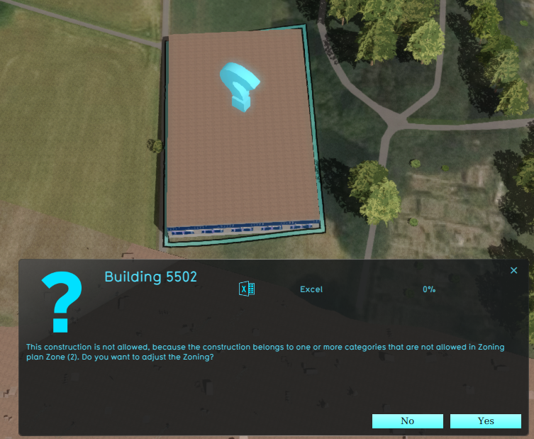
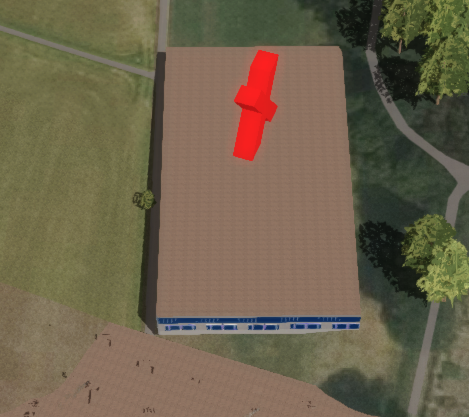
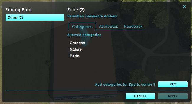
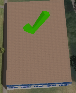
| | An example of a Stakeholder placing a new Sports Center in a Zone that does not allow it: |
| | | <gallery heights=300px widths=300px> |
| ==How to add and remove zones in the 3D world== | | File:zoning_conflict.png|A zone reports a conflict with the planned [[building]], because its [[Function Category]] is not allowed. |
| | | File:zoning_action_denied.png|Denying the action results in a message to revert the action. |
| : When a game's [[3D World]] is just created in the Tygron Engine's [[editor]], the whole selected game area is assigned as one default zone. When this game area is relatively small, this could work, however, it may be desired to divide the whole, or part of the game area up into multiple smaller zones.<br> | | File:zoning_adjust.png|The permitter decides to adjust the zoning plan, using the [[Zoning permit panel]]. |
| | | File:zoning_approves_action.png|The action now is in accordance with the zoning plan. |
| ===How to add zones to the 3D world===
| |
| {{Editor location|||3D World|Zoning}}
| |
| | |
| : To add new zones to the 3D world, open the Zoning panel in the editor. By right-clicking with the mouse on the field "Zones", on the left side of the Zoning panel, a context menu appears with the option "Add". Selecting this option creates a new entry in the "Zones" field, called "A New Item". Please note that this is still an "empty" zone, since no actual area is assigned yet. [[#How to change the implemented zoning|(See below:How to change the implemented zoning)]]
| |
| | |
| {{Editor steps|title=add zones to the 3D world|Open the Zoning panel|Right-click with mouse on the "Zones" field|Select "Add" from the context menu|A new (empty) zone is created in the list}}
| |
| | |
| <gallery mode="nolines">
| |
| Image:zoning3.jpg|Zoning Panel
| |
| Image:zoning4.jpg|Adding a zone
| |
| </gallery>
| |
| | |
| ===How to remove zones from the 3D world===
| |
| {{Editor location|||3D World|Zoning}}
| |
| | |
| : To remove a zone from the list, right-click on the zone that needs to be removed, and select "Delete" from the context menu. An extra message will appear for confirmation, to ensure nothing is deleted by accident.<br>
| |
| | |
| {{Editor steps|title=remove zones from the 3D world|Open the Zoning panel|Right-click with mouse on the zone to be removed|Select "Delete" from the context menu|Confirm the removal of the zone on the Confirmation Message}}
| |
| | |
| <gallery mode="nolines">
| |
| Image:zoning3.jpg|Zoning Panel
| |
| Image:zoning5.jpg|Deleting a zone
| |
| Image:zoning6.jpg|Confirmation message
| |
| </gallery>
| |
| | |
| ==How to change the implemented zoning==
| |
| {{Editor location|||3D World|Zoning}}
| |
| | |
| <gallery mode="nolines">
| |
| File:zoning3.jpg|Zoning Panel
| |
| </gallery>
| |
| | |
| : Editing a zone occurs on the Zoning panel. Here the following attributes can be changed to a zone:
| |
| | |
| ====Zone Name====
| |
| : ''The Zone name field is where the name of a zone can be changed. The "Name" of a zone is reflected in game on the zoning [[overlay]]. By entering a new name in the "Name" field, the zone can be given a more identifying name.''
| |
| <gallery mode="nolines">
| |
| File:zoning7.jpg|Naming a zone | |
| </gallery>
| |
| | |
| ====Zone ID Color====
| |
| :''The ID Color panel allows the Zone color to be editied. The Zone ID Color is reflected in the game on the zoning [[overlay]]. The Zone ID Color is used for assigning different colours to different zones, to help players to distinguish the defined zones. By pressing the right-mouse button above the "ID color" field, a new context menu opens, from where a new identification color for the highlighted zone can be selected. ''
| |
| <gallery mode="nolines">
| |
| File:zoning8.jpg|Assigning an ID color to a zone
| |
| </gallery> | | </gallery> |
|
| |
|
| ====Draw Area====
| |
| :''The Draw Area is used to assign an area in the 3D World to a specific zone. The assigned area is reflected in the selected Zone ID color game on the zoning [[overlay]]. To assign an area in the 3D world to a zone, select the "Draw Area" button. This will open the [[brush|brush panel]] to assign an area to the selected zone.''
| |
|
| |
|
| :''Please note that it is also possible to overdraw a previously assigned zone.''
| | {{article end |
| | |howtos= |
| | * [[How to add and remove a Zone]] |
| | * [[How to edit Zone properties]] |
| | |seealso= |
| | * [[Zoning permit panel]] |
| | }} |
|
| |
|
| <gallery mode="nolines">
| | {{Template:Editor current situation nav}} |
| File:zoning9a.jpg|Draw Area button
| |
| File:zoning9.jpg|Drawing the zone
| |
| </gallery>
| |
| | |
| ====Description====
| |
| :''The Description field is for describing the selected zone. Here a short text describing the zone can be entered. This field is currently still work in progress; for now this text can be used as reference when editing the zoning. In the near future this text is also to show up in game.''
| |
| <gallery mode="nolines">
| |
| File:zoning10.jpg|Description Field
| |
| </gallery>
| |
| | |
| ====Maximum amount of floors allowed in this zone====
| |
| : ''This field allows the maximum amount of floors to be set for the zone. This is commonly used to influence the skyline, population density and other urban planning issues. In a densely populated big city, having higher buildings helps creating living and working spaces for the inhabitants. In rural areas or outskirts, preservation of a more natural skyline might be desired.''
| |
| <gallery mode="nolines">
| |
| File:zoning11.jpg|Setting the allowed amount of floors
| |
| </gallery>
| |
| | |
| ====Allowed zoning function types====
| |
| =====Adding allowed types=====
| |
| : ''Adding an allowed function to a zone enables players to plan a construction type of this function inside the zone.''
| |
| | |
| : ''The bottom field on the Zoning panel is used to assign allowed functions to the selected zone. Zones can be assigned different functions, usually complementary to eachother; for example housing and shops, but not industry, in the same zone. To add an allowed function to a zone, right click on the field and select "Add" from the context menu. A new panel appears with categories available for selection. After confirmation of the selection, the category will show up in the list of allowed function/ construction types.''
| |
| | |
| {{Editor steps|title=add allowed function types to a zone|Open the Zoning Panel|Right-click on the bottom field|Select "Add" from the context menu|Select the desired function/ construction type from the newly opened panel|Confirm the selection?Notice the newly added item appears in the list}} | |
| | |
| <gallery mode="nolines">
| |
| File:zoning12a.jpg|Adding a zoning category
| |
| File:zoning12b.jpg|Selecting a zoning category
| |
| </gallery>
| |
| | |
| =====Removing allowed types=====
| |
| | |
| : ''To delete an assigned category, highlight it and right-click. Now select the option "Delete" from the context menu. Of course an extra confirmation panel will appear again, to avoid accidental deletion of categories.'' | |
| | |
| {{Editor steps|title=remove allowed function types from a zone|Open the Zoning Panel|Right-click on the item on the bottom field to be removed|Select "Delete" from the context menu|Confirm the removal on the next Confirmation Message|Notice the entry on the list has been removed}}
| |
| | |
| <gallery mode="nolines">
| |
| File:zoning13.jpg|Deleting a zoning category
| |
| File:zoning6.jpg|Confirmation message
| |
| </gallery>
| |
| <br clear=all>
| |