Flooding Overlay: Difference between revisions
Jump to navigation
Jump to search
No edit summary |
|||
| Line 1: | Line 1: | ||
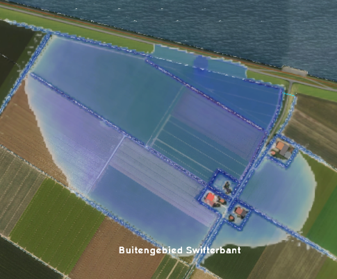
[[File:FloodingOverlay2.png|right|thumb|200px|Flooding overlay]] | [[File:FloodingOverlay2.png|right|thumb|200px|Flooding overlay]] | ||
The Flooding overlay uses the [[Water Module|water module]] in the Tygron Platform to calculate and visualize the movement of water over land in combination with a [[Breach|breach]] or other [[Inlet|inflow]] of water in the project [[Water area|water area(s)]]. | The Flooding overlay uses the [[Water Module|water module]] in the Tygron Platform to calculate and visualize the movement of water over land in combination with a [[Breach|breach]] or other [[Inlet|inflow]] of water in the project [[Water area|water area(s)]]. | ||
==Water module== | |||
For further information: [[Water Module]] | |||
==Flooding overlay results== | ==Flooding overlay results== | ||
[[Results (Water Overlay)|Flooding overlay results]]<br> | [[Results (Water Overlay)|Flooding overlay results]]<br> | ||
[[Result type (Water Overlay)#List of Result Types|List of Result Types]] | [[Result type (Water Overlay)#List of Result Types|List of Result Types]] | ||
{{Template:Overlay nav}} | {{Template:Overlay nav}} | ||
Revision as of 14:02, 9 April 2019
The Flooding overlay uses the water module in the Tygron Platform to calculate and visualize the movement of water over land in combination with a breach or other inflow of water in the project water area(s).
Water module
For further information: Water Module
Flooding overlay results
Flooding overlay results
List of Result Types
