Shoreline (Water Overlay): Difference between revisions
Jump to navigation
Jump to search
No edit summary |
No edit summary |
||
| (9 intermediate revisions by 3 users not shown) | |||
| Line 1: | Line 1: | ||
{{Overlay | {{Overlay attributes|<onlyinclude> | ||
{{Overlay attributes|type=row|overlay=Water | |||
|attribute=SHORELINE | |attribute=SHORELINE | ||
|unit=boolean | |unit=boolean | ||
|description=When a Waterway polygon is not correctly positioned in relation to the DEM this can result in filling up the nearby land with water at the start of the simulation. | |icon=Waterwizard_icon_shoreline.png | ||
|description=Whether to automatically fill cells near a water terrain when there is a mismatch between the extend of the water terrain and the DEM. | |||
|defaultvalue=True | |||
}}</onlyinclude>}} | |||
When a Waterway polygon is not correctly positioned in relation to the DEM this can result in filling up the nearby land with water at the start of the simulation. This will result in a lower water level then is expected from the water area value. To correct this, a "shoreline" is added at neighbouring cells. At the start of the simulation, these shoreline cells will also be filled with water up to the nearby water level to prevent the initial flush. | |||
<gallery mode=nolines> | |||
File:Wateroverlay_shoreline.png|Water Overlay with shoreline active. | |||
File:Wateroverlay_without_shoreline.png|Water Overlay without shoreline active. | |||
File:Wateroverlay_difference_waterlevel.png|Difference in [[Surface last value result type (Water Overlay)|water level]]. | |||
</gallery> | |||
{{article end | |||
|notes= | |||
* This option is active by default. | |||
* Shoreline currently only extends to one grid cell in each direction, as can be seen in the images above. | |||
|howtos= | |||
* [[How to add and remove an Attribute]] | |||
}} | }} | ||
{{WaterOverlay model attribute nav}} | |||
{{ | |||
Latest revision as of 10:29, 29 January 2024
| Icon | Attribute | Unit | Range | Description | Default value |
|---|---|---|---|---|---|
| |
SHORELINE | boolean | Whether to automatically fill cells near a water terrain when there is a mismatch between the extend of the water terrain and the DEM. | True |
When a Waterway polygon is not correctly positioned in relation to the DEM this can result in filling up the nearby land with water at the start of the simulation. This will result in a lower water level then is expected from the water area value. To correct this, a "shoreline" is added at neighbouring cells. At the start of the simulation, these shoreline cells will also be filled with water up to the nearby water level to prevent the initial flush.
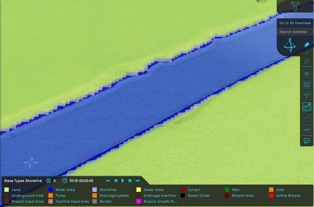
Water Overlay with shoreline active.
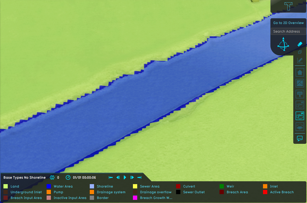
Water Overlay without shoreline active.
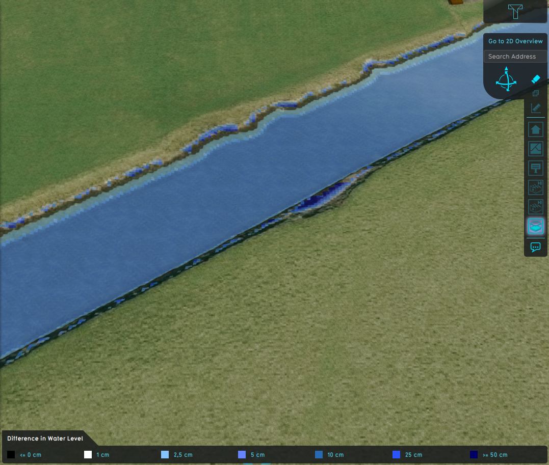
Difference in water level.


Notes
- This option is active by default.
- Shoreline currently only extends to one grid cell in each direction, as can be seen in the images above.
How-to's


- Group
- Model attributes
- Allowed water increase m • Avg shore width m • Avg terrain width m • Avg terrain storage m • Breach measurement distance m • Bridge elevation • Culvert dem threshold m • Design flood elevation m • Extended reconstruction • Ground bottom distance m • Ground bottom pressure m • Ground water • Ground water depth m • Ground watertable with surface • Impact flood threshold m • Impact range m • Increased resolution • Infiltration factor s
- Limit area • Limit rain • Max infiltration m • Max water bottom m • Microrelief storage fraction • Min max elevation • Object entry correction • Prequel surface level relative • Rise rate distance m • Sewer overflow threshold • Shoreline • Show duration flood level m • Stabilizer angle • Start date ms • Surface water • Surface water evaporation factor • Timeframe times • Timeframes • Unsaturated fraction • Weir dam multiplier • Weir move interval s • Weir move range m • Weir move step m
- Related