I3S: Difference between revisions
No edit summary |
No edit summary |
||
| Line 1: | Line 1: | ||
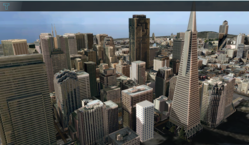
[[File:San_francisco.png|thumb|300px|right|Custom geometries of San Francisco from an I3S Service, visualized in the {{software}}]] | [[File:San_francisco.png|thumb|300px|right|Custom geometries of San Francisco from an I3S Service, visualized in the {{software}}]] | ||
Indexed 3D Scene Layer Specification (I3S) is a format for large 3D Geo datasets. The specification was mainly designed for streaming large 3D visualization data over the web. The specification was originally designed by Esri and was adopted as a Community Standard by the OGC (Open Geospatial Consortium) in 2017. In ArcGIS software, an I3S dataset can be visualized using a Scene Layer. | Indexed 3D Scene Layer Specification<ref>https://www.ogc.org/standard/i3s/</ref> (I3S) is a format for large 3D Geo datasets. The specification was mainly designed for streaming large 3D visualization data over the web. The specification was originally designed by Esri and was adopted as a Community Standard by the OGC (Open Geospatial Consortium) in 2017. In ArcGIS software, an I3S dataset can be visualized using a Scene Layer. | ||
In the {{software}} it is possible to add your own 3D models as [[Custom Geometries]]. A format for these models which the {{software}} supports is I3S, along with the other format [[CityGML]]. <br> | In the {{software}} it is possible to add your own 3D models as [[Custom Geometries]]. A format for these models which the {{software}} supports is I3S, along with the other format [[CityGML]]. <br> | ||
| Line 19: | Line 19: | ||
|seealso= | |seealso= | ||
* [[Custom Geometries]] | * [[Custom Geometries]] | ||
|references= | |||
}} | }} | ||
{{Template:GeoDataOverview}} | {{Template:GeoDataOverview}} | ||
Revision as of 12:57, 3 October 2023
Indexed 3D Scene Layer Specification[1] (I3S) is a format for large 3D Geo datasets. The specification was mainly designed for streaming large 3D visualization data over the web. The specification was originally designed by Esri and was adopted as a Community Standard by the OGC (Open Geospatial Consortium) in 2017. In ArcGIS software, an I3S dataset can be visualized using a Scene Layer.
In the Tygron Platform it is possible to add your own 3D models as Custom Geometries. A format for these models which the Tygron Platform supports is I3S, along with the other format CityGML.
Different other formats, such as BIM data or a SketchUp model, can be converted to the I3S format with a SLPK file. Read on to learn more about this.
I3S and SLPK
A Scene Layer Package (SLPK) is a file format for the storage/exchange of one or more I3S layers. SLPK's can be used to import both into your project once it has been created.
2D versus 3D
Generally, I3S Services and SLPK files are used to import Custom Geometries, that provide an alternative 3D visualization, for existing or new Buildings. I3S services and SLPK files can also be used to import 2D spatial data for items such as Areas and Terrains. However, the support for additional attributes is currently limited.
How-to's
See also
