For the 3-30-300 guidelines, the rule indicated by the "300" is residences must be within 300 meters (walking distance) of accessible and usable green at least 1 hectare in size. This can be computed in the Tygron Platform by creating a determination of what green qualifies as accessible and usable green, where at least 1 hectare of such green exists, what green is part of that 1 hectare structure, and what routes towards that structure exists.
Create a Grid Overlay (using a Combo Overlay is recommended) which highlights which locations are to be considered "public space", such that: Name: Public space Locations which are not publicly accessible have a value of 0. Locations which are publicly accessible have a value of 1.
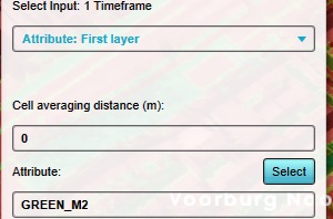
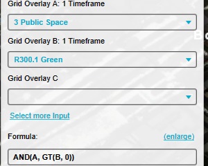
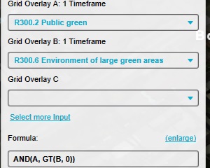
Add a Combo Overlay, configured so that: Name: Public green Input A: "Public space" Overlay. Input B:"Green" Overlay. Formula: AND(A, GT(B, 0))
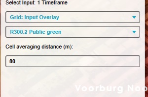
Add an Average Overlay, configured so that: Name: Fraction of green nearby Input is a Grid Input Overlay. Input: The "Public green" Overlay. Averaging distance is 80.
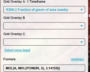
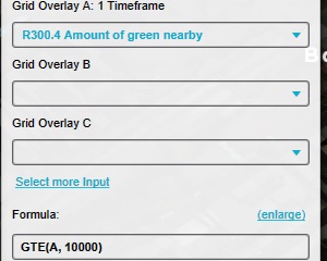
Add a Combo Overlay, configured so that: Name: Amount of green nearby Input A: The "Fraction of green nearby" Overlay. Formula: MUL(A, MUL(POW(80, 2), 3.14159))
Add a Combo Overlay, configured so that: Name: 1 hectare of green Input A: The "Amount of green nearby" Overlay. Formula: GTE(A, 10000)
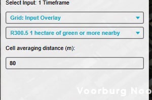
Add an Average Overlay configured so that: Name: Environment of large green areas Input is a Grid Input Overlay. Input: The "1 hectare of green" Overlay. Averaging distance is 80.
Add a Combo Overlay, configured so that: Name: Large green areas Input A: The "Public green" Overlay. Input B: The "Environment of large green areas" Overlay. Formula: AND(A, GT(B, 0))
Add a Travel Distance Overlay configured using the wizard such that: Destinations grid: based on grid overlay "Large green areas". Destination threshold: 1. Max travel distance: 290. Distance to road: 30.
Traffic Types: Pedestrians, Bicycles, and Cars.
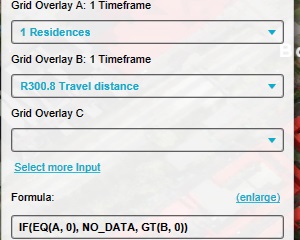
Add a Combo Overlay, configured so that: Name: Residences with green nearby Input A: The "Residences" Overlay. Input B: The Travel Distance Overlay. Formula: IF(EQ(A, 0), NO_DATA, GT(B, 0))
Configure the legend of the Combo Overlay to have a distinct entry for the value "0" and the value "1".
There is not yet a standardized way to define which locations do or do not qualify as a "Public space". A fair approximation would be to exclude the combined results of an Average Overlay directed at SOLID, and an Average Overlay directed at PRIVATE_YARD.