How to compute residences within walking distance of significant usable public green: Difference between revisions
Jump to navigation
Jump to search
mNo edit summary |
No edit summary |
||
| (4 intermediate revisions by 2 users not shown) | |||
| Line 8: | Line 8: | ||
| Create a [[Grid Overlay]] (using a [[Combo Overlay]] is recommended) which highlights which locations are to be considered "public space", such that: | Name: Public space | Locations which are not publicly accessible have a value of 0. | Locations which are publicly accessible have a value of 1. }} | | Create a [[Grid Overlay]] (using a [[Combo Overlay]] is recommended) which highlights which locations are to be considered "public space", such that: | Name: Public space | Locations which are not publicly accessible have a value of 0. | Locations which are publicly accessible have a value of 1. }} | ||
| {{ howtoblock | image=300-rule-howto-1-green.jpg | | {{ howtoblock | image=300-rule-howto-1-green.jpg | ||
| Add an [[Average Overlay]], configured so that: | Name: Green | Attribute to average is [[ | | Add an [[Average Overlay]], configured so that: | Name: Green | Attribute to average is [[vegetation fraction (Function Value)|VEGETATION_FRACTION]] | Averaging distance is 0. }} | ||
| {{ howtoblock | image=300-rule-howto-2-public-green.jpg | | {{ howtoblock | image=300-rule-howto-2-public-green.jpg | ||
| Add a [[Combo Overlay]], configured so that: | Name: Public green | Input A: "Public space" Overlay. | Input B:"Green" Overlay. | Formula: AND(A, GT(B, 0)) }} | | Add a [[Combo Overlay]], configured so that: | Name: Public green | Input A: "Public space" Overlay. | Input B:"Green" Overlay. | Formula: AND(A, GT(B, 0)) }} | ||
| Line 32: | Line 32: | ||
| notes= | | notes= | ||
* If the [[Travel Distance Overlay]] does not properly calculate travel routes across certain [[Function]]s, such as bicycle paths or pavements, it may be neccessary to change the [[Function Value]]s of those [[Function]]s, specifically the [[Bicycles per hour (Function Value)|NUM_BICYCLES]] and the [[Pedestrians per hour (Function Value)|NUM_PEDESTRIANS]]. | * If the [[Travel Distance Overlay]] does not properly calculate travel routes across certain [[Function]]s, such as bicycle paths or pavements, it may be neccessary to change the [[Function Value]]s of those [[Function]]s, specifically the [[Bicycles per hour (Function Value)|NUM_BICYCLES]] and the [[Pedestrians per hour (Function Value)|NUM_PEDESTRIANS]]. | ||
* There is not yet a standardized way to define which locations do or do not qualify as a "Public space". A fair approximation would excluding the combined results of an [[Average Overlay]] directed at [[Solid ( | * There is not yet a standardized way to define which locations do or do not qualify as a "Public space". A fair approximation would excluding the combined results of an [[Average Overlay]] directed at [[Solid (Function Value)|SOLID]], and an [[Average Overlay]] directed at [[Private yard (Building Attribute)|PRIVATE_YARD]]. | ||
|seealso= | |seealso= | ||
* [[Demo 3-30-300 Project]] | * [[Demo 3-30-300 Project]] | ||
}} | }} | ||
[[Category:How-to's]] | |||
Latest revision as of 13:31, 30 January 2024
For the 3-30-300 guidelines, the rule indicated by the "300" is residences must be within 300 meters (walking distance) of accessible and usable green at least 1 hectare in size. This can be computed in the Tygron Platform by creating a determination of what green qualifies as accessible and usable green, where at least 1 hectare of such green exists, what green is part of that 1 hectare structure, and what routes towards that structure exists.
How to compute residences within walking distance of significant usable public green:
- Create a Grid Overlay of residences.
- Create a Grid Overlay (using a Combo Overlay is recommended) which highlights which locations are to be considered "public space", such that:
Name: Public space
Locations which are not publicly accessible have a value of 0.
Locations which are publicly accessible have a value of 1. - Add an Average Overlay, configured so that:
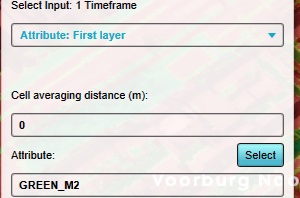
Name: Green
Attribute to average is VEGETATION_FRACTION
Averaging distance is 0. - Add a Combo Overlay, configured so that:
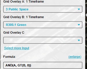
Name: Public green
Input A: "Public space" Overlay.
Input B:"Green" Overlay.
Formula: AND(A, GT(B, 0)) - Add an Average Overlay, configured so that:
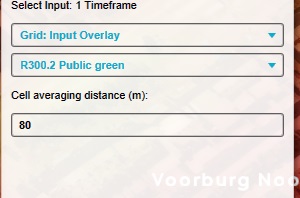
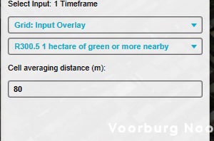
Name: Fraction of green nearby
Input is a Grid Input Overlay.
Input: The "Public green" Overlay.
Averaging distance is 80. - Add a Combo Overlay, configured so that:
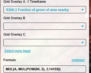
Name: Amount of green nearby
Input A: The "Fraction of green nearby" Overlay.
Formula: MUL(A, MUL(POW(80, 2), 3.14159)) - Add a Combo Overlay, configured so that:
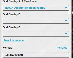
Name: 1 hectare of green
Input A: The "Amount of green nearby" Overlay.
Formula: GTE(A, 10000) - Add an Average Overlay configured so that:
Name: Environment of large green areas
Input is a Grid Input Overlay.
Input: The "1 hectare of green" Overlay.
Averaging distance is 80. - Add a Combo Overlay, configured so that:
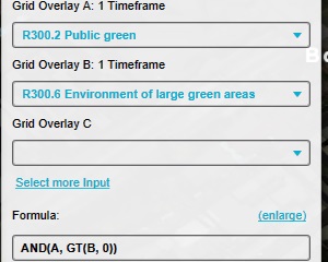
Name: Large green areas
Input A: The "Public green" Overlay.
Input B: The "Environment of large green areas" Overlay.
Formula: AND(A, GT(B, 0)) - Add a Travel Distance Overlay configured using the wizard such that:
Destinations grid: based on grid overlay "Large green areas".
Destination threshold: 1.
Max travel distance: 290.
Distance to road: 30. - Traffic Types: Pedestrians, Bicycles, and Cars.
- Add a Combo Overlay, configured so that:
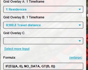
Name: Residences with green nearby
Input A: The "Residences" Overlay.
Input B: The Travel Distance Overlay.
Formula: IF(EQ(A, 0), NO_DATA, GT(B, 0)) - Configure the legend of the Combo Overlay to have a distinct entry for the value "0" and the value "1".


Notes
- If the Travel Distance Overlay does not properly calculate travel routes across certain Functions, such as bicycle paths or pavements, it may be neccessary to change the Function Values of those Functions, specifically the NUM_BICYCLES and the NUM_PEDESTRIANS.
- There is not yet a standardized way to define which locations do or do not qualify as a "Public space". A fair approximation would excluding the combined results of an Average Overlay directed at SOLID, and an Average Overlay directed at PRIVATE_YARD.