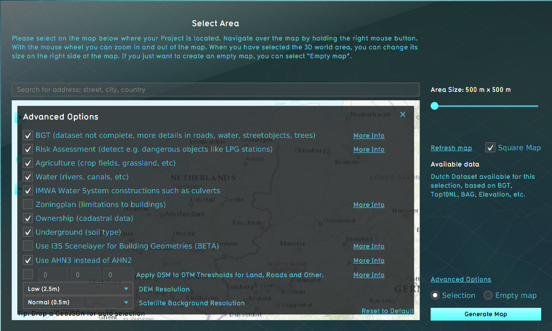
Advanced options (New Project Wizard)
What is the advanced options panel
The advanced options panel in the Wizard allows you to make a selection of data sources you want to use for creating your new project. It varies between the option to select or deselect a data source and change some settings like the resolution of data sources.
Where to find the advanced options
When choosing the location of the project area during the New project Wizard, in the second panel of the wizard, the default mode for data selection is Selection. When this option is checked, the Tygron Platform will acquire datasets from a variety of open datasets that are linked to the selected area. Find an overview on which data is used to create a new 3D model on the Project Sources page. The Advanced Options panel can be found above the selection option. When you open this panel the list of a few of the open datasets is displayed. You can choose to include or excluded specific data sources in your project creation.
Options
A number of options are available.
Datasources
- Main article: Project Sources
A number of Project Sources can be activated or deactivated. This leads entirely to some types of data being included or not, or downgraded to data from another data source.
| Datatype | Source | Fallback | Effect |
|---|---|---|---|
| Constructions and spatial features | BGT | BAG | The BGT has greater detail than the BAG. |
| Risk Assesment | Risicokaart | - | Constructions are added and enriched with safety zones when present in the Projects location. |
| Agriculture | BRP | - | Crop fields, grassland for livestock, and other agrarian fields are loaded in as Cosntructions. Deactivating it will leave most agrarian fields empty. |
| Waterschapshuis | IMWA | - | Water system Constructions such as Culverts are retrieved from IMWA. Deactivating it will omit Constructions relevant for water systems. |
| Zoningplan | Ruimtelijke plannen | - | Zoning plans are added to the Project, with restrictions on what kind of Constructions can be placed in what locations. Deactivating it will omit the zoning plan entirely. |
| Underground | BRO | - | The underground Terrain is based on data from the BRO. Deactivating it will leave the underground entirely unknown. |
| I3S Scenelayer | I3S Scenelayer | - | Using I3S allows 3D models to be visualized for existing constructions. Otherwise Tygron uses its internal polygon-based Construction visualization technique. |
| Elevation model | AHN3 | AHN2 | The AHN3 is newer and more accurate than the AHN2. Both serve as direct input for the elevation model. |
Enrichments
A number of options serve only as enrichments. The related data sources are not disabled entirely, but a specific type of data is not added to the Project.
| Datatype | Source | Effect |
|---|---|---|
| Water | BGT / BAG | When activated, the BGT or BAG are used to add water to the Project. If deactivated, no water is added to the Project. |
| Ownership | BRK | Constructions are assigned ownership based on cadastral information combined with default assumptions connected to types of Constructions, and empty land belonging to the local municipality. If deactivated, all land will belong to the local municipality. Note that this still means Projects on municipal borders will still have land owned by different municipal Stakeholders, and that Stakeholders are still generated for the Project based on the types of Constructions presents in the project area. |
Elevation model thresholds
If desired it's possible prefer using the DSM rather than the DTM when generating the elevation model for a new Project. This option can be useful when the data in the AHN is too much averaged and smoothed and more variation is desirable. When activated, the average DTM and DSM values within the polygons of certain features are compared. If the difference between the DTM and the DSM is small enough (i.e. smaller than the configured threshold), the value of the DSM is used. Otherwise, the value of the DTM is used.
It's possible to configure 3 thresholds in the following order:
| Feature | Default threshold | Difference less than threshold | Difference greater than threshold |
|---|---|---|---|
| Bare land | 1 m | The DSM value is used | The DTM value is used |
| Roads | 0.25 m | The DSM value is used | The DTM value is used |
| Crop fields/agriculture | 0.50 m | The DSM value is used | The DTM value is used |
Elevation model resolution
Depending on the Project's use-case, the elevation model may need to be very accurate. For example, the Water Overlay can take very small variations into account when calculation water flow. If a more accurate resolution is selected, more detailed versions of the DTM and DSM are used to create the elevation model with.
Satellite map detail
All Terrain in a Project is textured using a satellite map from World Imagery. The level of detail of the satellite map can be changed. A higher resolution looks better.
