Geo Data: Difference between revisions
No edit summary |
No edit summary |
||
| (217 intermediate revisions by 9 users not shown) | |||
| Line 1: | Line 1: | ||
Geographical data or geo data is data which have a location component. Almost all data is linked to a location or a place and are, therefore, geo data. Geo data can be, for example, a paper map, a digital web map or just a simple text file with coordinates. Geo datasets is either '''vector data''' (that is, features which are points, lines or polygons) or '''raster data''' (that is, data in grid cells). The features in vector data can have multiple attributes with values. Raster data mostly consist of a value and a color. | |||
{{ | ==How do Geo datasets relate to the {{software}}== | ||
[[File:Generate_3D_world_databases.png|Load data from databases|thumb|400px|left|Tygron Platform loading screen showing several of the data connections]] | |||
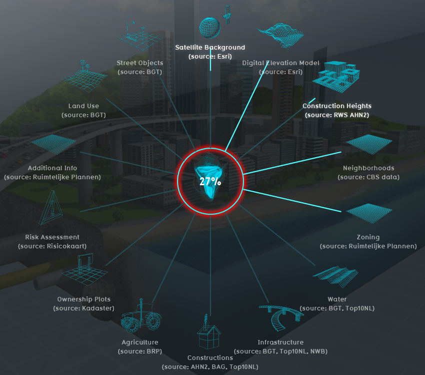
The {{software}} uses Geo data (vector and raster data) for building up a new [[project]]. For this, the {{software}} automatically connects to (Open) [[Project_Sources#Sources_connected_to_the_Tygron_Platform|Datasets]], based on the availability of the data for the chosen location of the project. For example the Base Registers in the Netherlands and Open Street Maps worldwide. | |||
A principle that generally applies: if your project lacks certain information, then it is not available in the used datasets. <br> For more information on which data is used for your generating your project, see the [[Project_Sources#Sources_connected_to_the_Tygron_Platform|project sources]] page. | |||
To add missing Geo data you can add additional Geo data manually (see below for options). | |||
<br clear=all> | |||
== | ==When to use your own data== | ||
* The project takes place in a location for which there are no data sources available to create the project | |||
* The default data sources are not accurate or up-to-date enough | |||
* The default datasets are not detailed enough | |||
* To do a more extended analysis in the {{software}} | |||
* To use in combination with an Excel Indicator or Panel | |||
* For creating more overview in your project, for example by highlighting areas | |||
In these situations, it might be useful to overwrite or import data. | |||
== | ==View Geo data== | ||
To show Geo data in other software, such as a GIS, options are: | |||
* the [[Overlay]]s can be obtained through a [[WMS]] URL. See the [[WMS]] page for more information and steps. | |||
* the [[Buildings]] can be obtained through a [[WFS]] URL. See the [[WFS]] page for more information and steps. | |||
==See also== | |||
* [[Import_Geo_data|Import Geo data]] | |||
* [[Export_Geo_data|Export Geo data]] | |||
{{Template:GeoDataOverview}} | |||
Latest revision as of 16:22, 27 January 2023
Geographical data or geo data is data which have a location component. Almost all data is linked to a location or a place and are, therefore, geo data. Geo data can be, for example, a paper map, a digital web map or just a simple text file with coordinates. Geo datasets is either vector data (that is, features which are points, lines or polygons) or raster data (that is, data in grid cells). The features in vector data can have multiple attributes with values. Raster data mostly consist of a value and a color.
How do Geo datasets relate to the Tygron Platform
The Tygron Platform uses Geo data (vector and raster data) for building up a new project. For this, the Tygron Platform automatically connects to (Open) Datasets, based on the availability of the data for the chosen location of the project. For example the Base Registers in the Netherlands and Open Street Maps worldwide.
A principle that generally applies: if your project lacks certain information, then it is not available in the used datasets.
For more information on which data is used for your generating your project, see the project sources page.
To add missing Geo data you can add additional Geo data manually (see below for options).
When to use your own data
- The project takes place in a location for which there are no data sources available to create the project
- The default data sources are not accurate or up-to-date enough
- The default datasets are not detailed enough
- To do a more extended analysis in the Tygron Platform
- To use in combination with an Excel Indicator or Panel
- For creating more overview in your project, for example by highlighting areas
In these situations, it might be useful to overwrite or import data.
View Geo data
To show Geo data in other software, such as a GIS, options are:
- the Overlays can be obtained through a WMS URL. See the WMS page for more information and steps.
- the Buildings can be obtained through a WFS URL. See the WFS page for more information and steps.
See also
