|
|
| (134 intermediate revisions by 7 users not shown) |
| Line 1: |
Line 1: |
| {{being_updated}}
| | Geographical data or geo data is data which have a location component. Almost all data is linked to a location or a place and are, therefore, geo data. Geo data can be, for example, a paper map, a digital web map or just a simple text file with coordinates. Geo datasets is either '''vector data''' (that is, features which are points, lines or polygons) or '''raster data''' (that is, data in grid cells). The features in vector data can have multiple attributes with values. Raster data mostly consist of a value and a color. |
|
| |
|
| {{learned|what Geo Data is|how Geo Data relates to the Tygron Engine|what Geo Data sources are used|when to use Geo Data}} | | ==How do Geo datasets relate to the {{software}}== |
| | [[File:Generate_3D_world_databases.png|Load data from databases|thumb|400px|left|Tygron Platform loading screen showing several of the data connections]] |
| | The {{software}} uses Geo data (vector and raster data) for building up a new [[project]]. For this, the {{software}} automatically connects to (Open) [[Project_Sources#Sources_connected_to_the_Tygron_Platform|Datasets]], based on the availability of the data for the chosen location of the project. For example the Base Registers in the Netherlands and Open Street Maps worldwide. |
| | A principle that generally applies: if your project lacks certain information, then it is not available in the used datasets. <br> For more information on which data is used for your generating your project, see the [[Project_Sources#Sources_connected_to_the_Tygron_Platform|project sources]] page. |
| | To add missing Geo data you can add additional Geo data manually (see below for options). |
| | <br clear=all> |
|
| |
|
| ==What is Geo data== | | ==When to use your own data== |
| Geographical data or geo data is data which has a location component. Almost all data is linked to a location or a place and is therefore geo data. Geo data is for example a paper map, a digital web map but also just a simple text file with coordinates. Geo datasets are either vector (features which are points, lines or polygons) or raster data (data in grid cells). The features in vector data can have multiple attributes with values. Raster data mostly has a value and a color.
| | * The project takes place in a location for which there are no data sources available to create the project |
| | * The default data sources are not accurate or up-to-date enough |
| | * The default datasets are not detailed enough |
| | * To do a more extended analysis in the {{software}} |
| | * To use in combination with an Excel Indicator or Panel |
| | * For creating more overview in your project, for example by highlighting areas |
| | In these situations, it might be useful to overwrite or import data. |
|
| |
|
| ==How does Geo data relate to the Tygron Engine== | | ==View Geo data== |
| The Tygron Engine uses geo data (vector and raster) for creating the [[3D World|3D model world]]. For this, the engine automatically connects to Dutch Open Datasets, such as the base registers. For this process the following general principle applies: if your 3D World lacks certain information, it is not available in the used dataset. To add missing Geo data you can either update the information in the database and regenerate the 3D world, or you can add additional Geo data manually. More information about importing data is provided on the [[Geo Data Wizard#How_to_import_Geo_Data|Geo Data Wizard]] page.
| | To show Geo data in other software, such as a GIS, options are: |
| | * the [[Overlay]]s can be obtained through a [[WMS]] URL. See the [[WMS]] page for more information and steps. |
| | * the [[Buildings]] can be obtained through a [[WFS]] URL. See the [[WFS]] page for more information and steps. |
|
| |
|
| ==Which Geo datasets are used?== | | ==See also== |
| [[File:Generate_3D_world_databases.png|Load data from databases|400px|right]] | | * [[Import_Geo_data|Import Geo data]] |
| The following table contains the data sources that are automatically used when selecting a location in The Netherlands and creating a new project. When selecting a location outside The Netherlands some geo data has to be provided manually. The table below shows the datasets which are used for creating a project in the Netherlands.
| | * [[Export_Geo_data|Export Geo data]] |
|
| |
|
| {| class="wikitable" | | {{Template:GeoDataOverview}} |
| |-
| |
| ! Name
| |
| ! Description
| |
| ! Data format
| |
| ! Coverage
| |
| ! Source
| |
| ! More information
| |
| |-
| |
| | BGT
| |
| | Basisregistratie Grootschalige Topografie: Base register containining information regarding the topography. The dataset is very detailled and contains for instance roads, parks, trees, water surfaces and street objects.
| |
| | GML-File
| |
| | PDOK
| |
| | Netherlands
| |
| |
| |
| |-
| |
| | BAG
| |
| | Basisregistraties Adressen en Gebouwen: Base register containing data about buildings and addresses such as function, construction year and size and the geometry of the buildings.
| |
| | Netherlands
| |
| | OGC-service
| |
| | PDOK
| |
| |-
| |
| | Aerial View
| |
| | ESRI service
| |
| | ESRI / CycloMedia
| |
| | Satellite/aerial photos used to define the basic texture of landscapes and rooftop colors.
| |
| |-
| |
| | DEM
| |
| | ESRI service
| |
| | ESRI
| |
| | Digital Elevation Model: the terrain height (excluding buildings).
| |
| |-
| |
| | AHN 2/3
| |
| | ESRI service
| |
| | ESRI
| |
| | Actueel Hoogtebestand Nederland: Contains detailed elevation information (specifically for the Netherlands).
| |
| |-
| |
| | Neighborhoods
| |
| | OGC service
| |
| | PDOK / CBS
| |
| | Area information: Used to determine relevant communities/municipalities and neighborhoods and their specific characteristics.(specifically for the Netherlands).
| |
| | |
| |-
| |
| | Zoning information
| |
| | GML service
| |
| | Ruimtelijke Plannen
| |
| | Land-use/Zoning plans: Containins information about authorized dimensions and -functions of buildings. Also contains additional feature attributes such as Monumental status.(specifically for the Netherlands).
| |
| | |
| |-
| |
| | Top10NL
| |
| | OGC service
| |
| | Tygron / PDOK
| |
| | Contains geographical information. Used for location where BGT information is not available. (specifically for the Netherlands).
| |
| | |
| |-
| |
| | NWB
| |
| | OGC service
| |
| | PDOK
| |
| | Nationaal Wegen Bestand: Contains detailed information about the road infrastructure. For instance number of lanes and road type. Also contains a road ID used in conjunction with INWEVA (see below). (specifically for the Netherlands).
| |
| | |
| |-
| |
| | INWEVA
| |
| | Excel
| |
| | Rijkswaterstaat
| |
| | Inschatting Wegvakintensiteit: Contains general traffic information for all major roads in the Netherlands (information is based on a traffic model which is yearly updated).
| |
| |-
| |
| | BRP
| |
| | OGC service
| |
| | PDOK
| |
| | Basis Registratie Percelen: Used to determine information about agricultural land use (specifically for the Netherlands).
| |
| |-
| |
| | Cadastral map
| |
| | OGC service
| |
| | PDOK
| |
| | Information about parcel boundaries (specifically for the Netherlands).
| |
| |-
| |
| | CycloMedia
| |
| | CycloMedia
| |
| | CycloMedia
| |
| | Detailed building information about locations of windows, floors, wall color of buildings. (specifically for the Netherlands).
| |
| | |
| |-
| |
| | Risk map
| |
| | GML service
| |
| | Risicokaart.nl
| |
| | Information on hazardous- and / or nuisance buildings (for example LPG station). Also contains additional information on vulnerable buildings (hotels, pension, etc.).(specifically for the Netherlands).
| |
| | |
| |-
| |
| | Natura 2000
| |
| | OGC service
| |
| | PDOK
| |
| | Information about areas that are designated as a Natura2000 location (an EU wide project linking nature areas to one network).(specifically for the Netherlands).
| |
| |-
| |
| |}
| |
| | |
| ==When to use your own GEO Data?==
| |
| When a project takes place outside The Netherlands only ESRI data is (automatically) used to configure a 3D world. Besides landtype (i.e. water of land) and elevation, this does not contain any information about constructions and/or environmental characteristics. Therefore it is advised to make use of additional GEO data to complement your 3D world instead of creating the 3D world from scratch. Adding additional data can be done in different ways. First of all you can add [[GeoJSON]] files. In [[Case_3:_Creating_a_3D_Environment_Manually_Using_GIS_Data|use case 3]] an example is given of the Geo Data needed to built up a 3D environment. It is also possible to implement your own additional Geo data by using the inter-grade function of [[ Legacy_Terrains#How_to_import_ArcGIS_terrains|ArcGis]]. For this function you need to have an ArcGis account or make use of available open data.
| |
Geographical data or geo data is data which have a location component. Almost all data is linked to a location or a place and are, therefore, geo data. Geo data can be, for example, a paper map, a digital web map or just a simple text file with coordinates. Geo datasets is either vector data (that is, features which are points, lines or polygons) or raster data (that is, data in grid cells). The features in vector data can have multiple attributes with values. Raster data mostly consist of a value and a color.
How do Geo datasets relate to the Tygron Platform
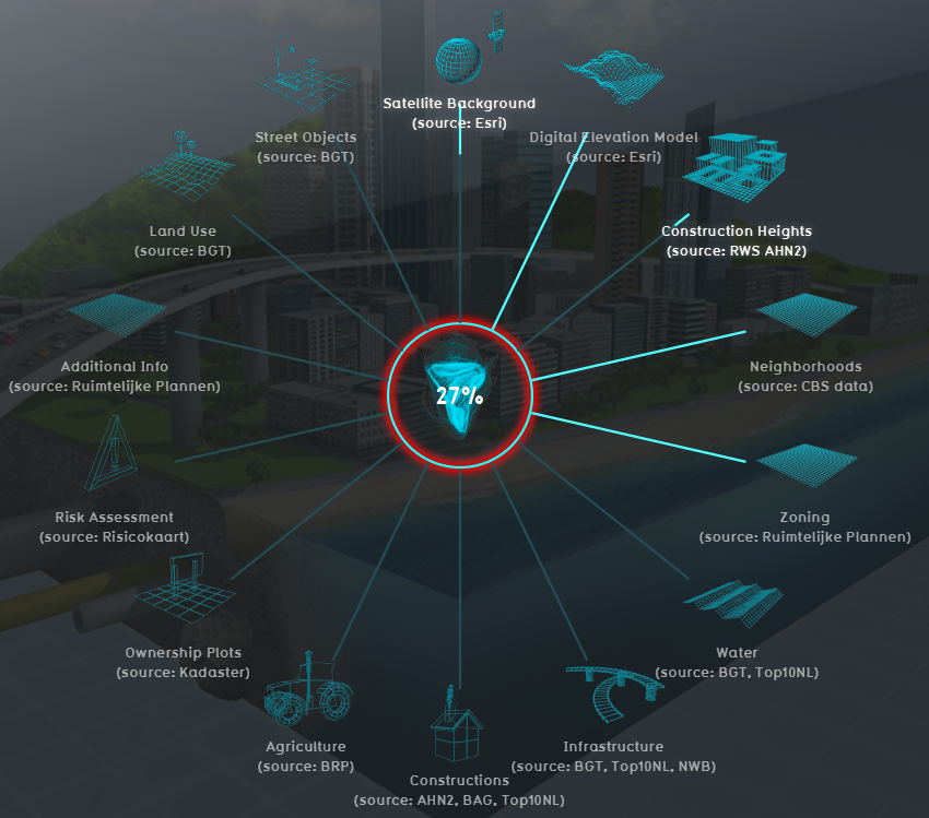
Tygron Platform loading screen showing several of the data connections
The Tygron Platform uses Geo data (vector and raster data) for building up a new project. For this, the Tygron Platform automatically connects to (Open) Datasets, based on the availability of the data for the chosen location of the project. For example the Base Registers in the Netherlands and Open Street Maps worldwide.
A principle that generally applies: if your project lacks certain information, then it is not available in the used datasets.
For more information on which data is used for your generating your project, see the project sources page.
To add missing Geo data you can add additional Geo data manually (see below for options).
When to use your own data
- The project takes place in a location for which there are no data sources available to create the project
- The default data sources are not accurate or up-to-date enough
- The default datasets are not detailed enough
- To do a more extended analysis in the Tygron Platform
- To use in combination with an Excel Indicator or Panel
- For creating more overview in your project, for example by highlighting areas
In these situations, it might be useful to overwrite or import data.
View Geo data
To show Geo data in other software, such as a GIS, options are:
- the Overlays can be obtained through a WMS URL. See the WMS page for more information and steps.
- the Buildings can be obtained through a WFS URL. See the WFS page for more information and steps.
See also
