Search results
Jump to navigation
Jump to search
Page title matches
- |name=Building elevation * The building elevation is interpreted as datum heights.646 bytes (91 words) - 14:11, 25 January 2024
- ...eightmap forms the base height information for the project in general, the elevation result type shows the way the [[terrain height (Water Overlay)|terrain heig * [[Elevation model (Water Overlay)|Elevation model]]1 KB (147 words) - 06:52, 30 October 2020
- ...e height of [[Building]]s below the normal [[terrain height]], a [[Terrain elevation prequel (Water Overlay)|prequel]] should be used instead.778 bytes (112 words) - 16:04, 17 January 2023

File:Waterwizard icon design flood elevation m.png (100 × 100 (6 KB)) - 11:35, 27 October 2022- #REDIRECT [[Design flood elevation m (Water Overlay)]]54 bytes (7 words) - 09:12, 9 May 2019
- ...[[Current Situation]] tab, hover over the Terrain button and click Select Elevation GeoTIFF ...sion Control|new version]] if you ever want to revert back to the original elevation model.2 KB (271 words) - 14:51, 1 February 2024
- ...when switching between [[Water (Terrain Attribute)|land and water]], the [[elevation model]] is altered automatically based on the [[Terrain Type]]'s [[Attribut ...ing [[Attribute]]s can be used to prepare a GeoJSON file, with which the [[elevation model]] can be altered. Each [[Attribute]] is effectively optional.4 KB (689 words) - 15:19, 30 January 2024
- ...lts of the [[Grid Overlay]]'s calculation can be directly applied to the [[elevation model]]. {{editor location|elevation grid overlay}}1 KB (196 words) - 16:20, 30 January 2024
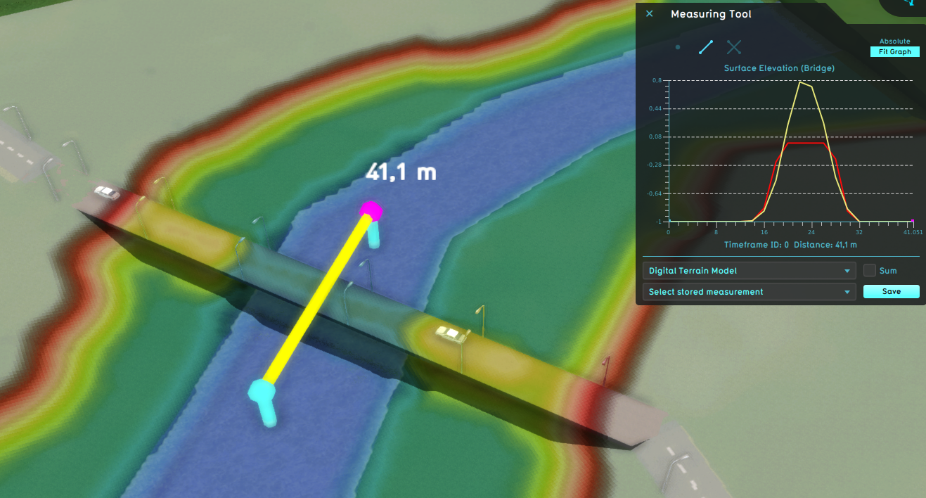
File:Bridge surface elevation bridge water.png (1,317 × 708 (949 KB)) - 10:52, 28 February 2024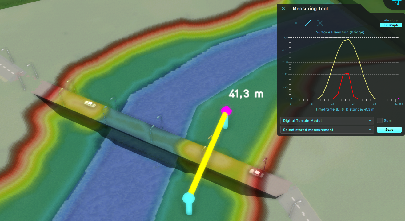
File:Bridge surface elevation bridge land.png (1,316 × 720 (958 KB)) - 10:52, 28 February 2024


Page text matches
- ...e)|water]] [[Terrain Type]], relative to the surrounding [[elevation model|elevation]].627 bytes (80 words) - 17:16, 27 February 2024
- |description=Load the [[Elevation model (Water Overlay)|DEM]] at twice the resolution. ...n interpolation step, so the interpreted [[Elevation model (Water Overlay)|elevation model]] becomes more accurate. This improves flow throughput in very small990 bytes (140 words) - 12:19, 27 October 2022
- | Terrain elevation {{nav-group| postappend= (Water Overlay) | Elevation1 KB (114 words) - 17:08, 30 January 2024
- ...[[Current Situation]] tab, hover over the Terrain button and click Select Elevation GeoTIFF ...sion Control|new version]] if you ever want to revert back to the original elevation model.2 KB (271 words) - 14:51, 1 February 2024
- | Elevation model | Elevation GeoTIFF1 KB (115 words) - 09:13, 9 March 2023
- #REDIRECT [[How to import a GeoTIFF to change the elevation model]]67 bytes (11 words) - 12:10, 26 June 2020
- #REDIRECT [[How to import a GeoJSON to change the elevation model]]67 bytes (11 words) - 06:48, 19 June 2020
- |functionvalue=Align Elevation ...rmines whether a [[Building]] is aligned relative to the [[Elevation_model|elevation model]] (in case of an uneven surface), flat on the ground, or floating.1 KB (149 words) - 14:32, 26 January 2024
- |name=Building elevation * The building elevation is interpreted as datum heights.646 bytes (91 words) - 14:11, 25 January 2024
- |name=Terrain elevation * The terrain elevation is interpreted as datum heights.643 bytes (91 words) - 14:11, 25 January 2024
- ...ation model, by taking the data of the indicated Overlay and adjusting the elevation model accordingly. | Go to Current Situation → Terrain → Select Elevation Grid Overlay3 KB (418 words) - 14:38, 1 February 2024
- ...d as you draw them, where you draw them. Applying the modifications to the elevation data is a separate, confirming step. {{Editor location|Terrain elevation}}2 KB (266 words) - 16:26, 30 January 2024
- ...ou can follow the generic steps on [[how to import a GeoJSON to change the elevation model]], selecting the appropriate type of water to import your features as {{:how to import a GeoJSON to change the elevation model1 KB (209 words) - 14:35, 29 February 2024
- ...rlay)|elevation]] or a [[Terrain elevation prequel (Water Overlay)|Terrain elevation prequel]].2 KB (247 words) - 15:18, 26 January 2024
- ...low up to the height defined by the overlay model attribute [[Design flood elevation m (Water Overlay)|DESIGN_FLOOD_ELEVATION_M]]. * [[Design flood elevation m (Water Overlay)]]792 bytes (107 words) - 16:08, 15 December 2023
- ...sh is a specific variation on the regular [[brush]], optimized for drawing elevation model modifications. It allows for two drawing modes: selection drawing, wh [[File:elevation-bottom.jpg|framed|left|The terrain height brush panel.]]4 KB (576 words) - 12:18, 1 February 2024
- | {{linkappend|post= (Water Overlay)|Elevation}} | [[Elevation model]]1 KB (184 words) - 16:53, 24 January 2024
- ...ng height. Taller buildings have their height capped at the [[Design flood elevation m model attribute (Water Overlay)|DESIGN_FLOOD_ELEVATION_M]] attribute's va * [[Elevation model (Water Overlay)]]1 KB (216 words) - 12:19, 27 February 2023
- {{:Bridge elevation (Water Overlay)}} {{:Design flood elevation m (Water Overlay)}}2 KB (262 words) - 09:23, 24 January 2024
- | Bridge elevation | Design flood elevation m2 KB (202 words) - 17:07, 30 January 2024