How to export AI Training Data: Difference between revisions
Jump to navigation
Jump to search
No edit summary |
No edit summary |
||
| Line 1: | Line 1: | ||
<youtube>Zue3st3zdUY</youtube> | <youtube>Zue3st3zdUY</youtube> | ||
This how-to explains how to generate | This how-to explains how to generate AI training data using the {{software}}. This data can be used to train your [[How to train your own AI model for an Inference Overlay|own AI model]]. | ||
{{editor steps|title= | {{editor steps|title= | ||
| Open a project in editor mode using the {{software client}} | | Open a project in editor mode using the {{software client}} | ||
| Optionally add a [[Satellite Overlay]]. This overlay will be used to export train images for the dataset. | | Optionally add a [[Satellite Overlay]]. This overlay will be used to export train images for the dataset. | ||
| Determine | | Determine which [item] type will be used to export the dataset. For example Foliage [[area]]s drawn on top of the satellite overlay. | ||
| Select the ''Export Geo Data'' option in the Ribbon bar popup of the selected item type. For example: Hover over Areas and select ''Export Geo Data'' | | Select the ''Export Geo Data'' option in the Ribbon bar popup of the selected item type. For example: Hover over Areas and select ''Export Geo Data'' | ||
| Under ''Format'', select the option '''AI Training Data PNG''' | | Under ''Format'', select the option '''AI Training Data PNG''' | ||
| Line 12: | Line 12: | ||
| Optionally select a prepared Intersection Area, for example a '''TRAIN_LIMIT_AREA'''. | | Optionally select a prepared Intersection Area, for example a '''TRAIN_LIMIT_AREA'''. | ||
| For the Overlay, select the preferred Overlay, for example the [[Satellite Overlay]]. | | For the Overlay, select the preferred Overlay, for example the [[Satellite Overlay]]. | ||
| The image size can increased, as long as the amount of expected features within the image does not exceed the maximum amount of 250. | | The image size can be increased, as long as the amount of expected features within the image does not exceed the maximum amount of 250. | ||
| The stride can be kept at 50% | | The stride can be kept at 50% | ||
| Click on the ''Export Files'' button | | Click on the ''Export Files'' button | ||
| Line 20: | Line 20: | ||
<gallery> | <gallery> | ||
File:export_ai_training_data_export_config.png|Configuration of the Export AI Training Data as | File:export_ai_training_data_export_config.png|Configuration of the Export AI Training Data as PNGs for Foliage [[Areas]] on a [[Satellite Overlay]], with an intersecting area. | ||
</gallery> | </gallery> | ||
| Line 29: | Line 29: | ||
* In case the feature sizes are small compared to the image size, the stride can be increased. | * In case the feature sizes are small compared to the image size, the stride can be increased. | ||
* A dataset can also be generated as '''AI Training Data CSV''', which allows users to directly train on float matrices instead of color images. | * A dataset can also be generated as '''AI Training Data CSV''', which allows users to directly train on float matrices instead of color images. | ||
* When the intended background image is not the satellite image provided by default but some other image or set of data, it is also possible to select a [[WMS Overlay]] referencing an external map service, or a [[Combo Overlay]], | * When the intended background image is not the satellite image provided by default but some other image or set of data, it is also possible to select a [[WMS Overlay]] referencing an external map service, or a [[Combo Overlay]], using its <code>COLOR</code> function to compute a custom image. | ||
|howtos= | |howtos= | ||
* [[How to train your own AI model for an Inference Overlay]] | * [[How to train your own AI model for an Inference Overlay]] | ||
Latest revision as of 14:30, 14 July 2026
This how-to explains how to generate AI training data using the Tygron Platform. This data can be used to train your own AI model.
How to export AI Training Data:
- Open a project in editor mode using the Tygron Client
- Optionally add a Satellite Overlay. This overlay will be used to export train images for the dataset.
- Determine which [item] type will be used to export the dataset. For example Foliage areas drawn on top of the satellite overlay.
- Select the Export Geo Data option in the Ribbon bar popup of the selected item type. For example: Hover over Areas and select Export Geo Data
- Under Format, select the option AI Training Data PNG
- Filter items with an attribute, such as FOLIAGE
- Optionally select a prepared Intersection Area, for example a TRAIN_LIMIT_AREA.
- For the Overlay, select the preferred Overlay, for example the Satellite Overlay.
- The image size can be increased, as long as the amount of expected features within the image does not exceed the maximum amount of 250.
- The stride can be kept at 50%
- Click on the Export Files button
- Select a suitable folder for the generated dataset.
- Wait until the dataset is fully generated.
-
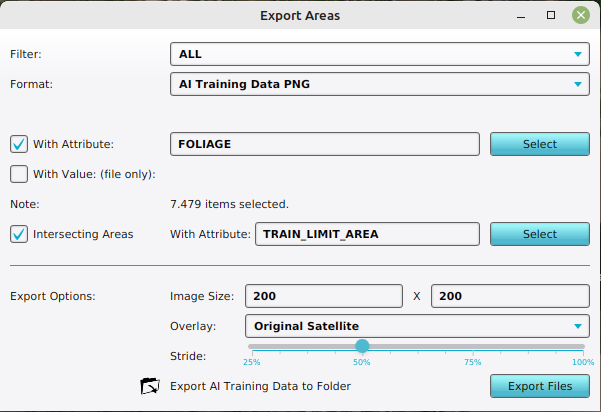 Configuration of the Export AI Training Data as PNGs for Foliage Areas on a Satellite Overlay, with an intersecting area.

Notes
- In case the export folder is not empty, a confirmation popup will appear on overriding the existing image, label, mask and bounding box files.
- In case a region intersects the limit area, but does not contain any features, it is still exported as a dataset-entry (image-, label-, mask- and bbox-file) but without labels, mask pixels or bounding box entries.
- In case the feature density is low, the image size can be increased.
- In case the feature sizes are small compared to the image size, the stride can be increased.
- A dataset can also be generated as AI Training Data CSV, which allows users to directly train on float matrices instead of color images.
- When the intended background image is not the satellite image provided by default but some other image or set of data, it is also possible to select a WMS Overlay referencing an external map service, or a Combo Overlay, using its
COLORfunction to compute a custom image.