Surface model (Water Overlay)
The Water Module's primary function is the simulation of the 2-dimensional flow of water on the surface. In order to simulate flowing water, the project area is discretized into x by y cells, based on the configured grid cell size.
Secondly a model is required which describes the rules that need to be followed. For this we use the two-dimensional Saint-Venant system, which reads:
In the Tygron Platform this model is implemented using the Well balanced, positivity preserving central-upwind scheme described in [1].
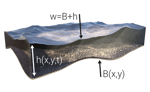
This method rewrite the h from the original Saint-Venant system to w = h + z. See the following image:
| Symbol | |
|---|---|
| B | surface elevation of grid cell |
| h | water height of grid cell |
| w | water level of grid cell |
For more information about the model's implementation, see Surface flow formula.
Surface water level initialization
The surface water level is initialized based on hydrological features present in the project. For all water terrains, water is placed on the surface of the world. The amount of water placed is such that the resulting water level in that location is equal to the WATER_LEVEL attribute of the Water level area in that location. If there is no water level area in that location, the water level is assumed to be so low that no water is created. Besides the water level areas, Inundation is added to the model. Water is placed in all locations where inundation is defined (regardless of the terrain type in that location, in contrast to the water level areas), such that the resulting height of the water inundating the land is equal to the inundation area's INUNDATION_LEVEL attribute.
After the surface is initialized with water, all water on the surface will flow in accordance with the same rules. It does not matter whether the water was created when the model was initialized, and whether that water was due to a water terrain or due to inundation, or whether the water came in from another source.
On the surface, water can flow from one cell to an adjacent cell based on the relative heights of the water, the slope of the terrain, and the manning value of the terrain or construction in that location.
In addition to water flowing between geographically adjacent cells, water can also flow through hydrological constructions. When a line-based hydrological construction exists in the project area, the 2 cells indicated by the endpoints of the line are considered adjacent as well. Flow between those cells is not dictated by the same parameters as the regular surface flow. Instead, water can flow between the 2 indicated cells based on the construction's underlying formula.
Water can also be added to or removed from the water model by point-based hydrological constructions. Based on the construction's underlying formula water can be added or removed to the cell indicated by the construction. Only that single cell will receive or lose the calculated amount of water.
Water can also be removed from the surface by other properties of constructions, based on the construction's polygons (either moving it to another part of the hydrological model, or removing it completely from the hydorlogical model). When water is removed from the surface via a polygon-based construction, the removal of water is calculated per individual cell.
- ↑ Cite error: Invalid
<ref>tag; no text was provided for refs namedref-reference

