|
|
| (73 intermediate revisions by 12 users not shown) |
| Line 1: |
Line 1: |
| After reading this page
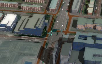
| | [[File:3DWorld2.jpg|right|thumb|{{software|client}}'s 3D Visualization with a textured height map, 3D building model and furniture, traffic and a skybox]] |
| * you've learned what the 3D World is
| | When using the [[{{software|client}}]], a three dimensional (3D) visualization of the selected [[project]] is rendered as a scene. |
| * you've learned how the 3D world relates to the Tygron Engine
| |
| * you've learned out of which elements the 3D world is created
| |
| * you've learned how to create a 3D world
| |
| * you've learned how to edit the 3D world
| |
| <br />
| |
| [[File:3dworld1.jpg|left]]<br clear=all> | |
|
| |
|
| === What is a 3D World? ===
| | The view into this 3D visualization is determined by the selected [[Camera]] mode, which also determine the way you can navigate using the mouse and keyboard controls. |
| : The 3D World is a visual representation in three dimensions of (a part of) the real world or a virtual area.
| |
|
| |
|
| === What is the function of the 3D World in the Tygron Engine? ===
| | The scene consists of: |
| | * A textured height map, based on the [[DTM]], [[Terrain]]s and [[Building]]s on top of it. |
| | * Construction and furniture models of [[Building]]s. |
| | * [[Traffic Model|Traffic vehicles]], either driving or stationary. |
| | * A sky box providing the background of the visualization. |
| | * Abstract visualizations, such as [[Network]] and [[System_visualization_(Water_Overlay)|Water System visualization]], based on the selected [[Water Overlay]]. |
| | * Labels indicator [[Neighborhood]]s and street names. |
| | * Informational [[popup]]s on locations of interest. |
| | * Shaders that enhance the visualization, such as water and shadows and the cursor location. |
| | * [[Flooding Overlay|Flooding]] and [[weather]] effects. |
| | * Special effects placed in the projects, spawning particles such as smoke. |
| | * Visualize [[Overlay]]s. These overlays can also be inspected by interacting with the scene to show hover information of clicked locations. |
|
| |
|
| : When playing a game in the Tygron Engine, a three dimensional (3D) visualization of the game area is rendered. In this 3D world the players can together navigate and perform their stakeholders' actions. The effects of their actions are also instantly visualized, delivering direct visual feedback. When for example a stakeholder's action negatively affects water storage in the game area, floods will occur and be displayed during heavy rain fall. | | ==Cursor highlight== |
| [[File:3DWorld2.jpg|left|thumb|Tygron Engine 3D World]]<br clear=all>
| | [[File:cursor_highlight_3D_visualization.jpg|thumb|right|The cursor highlight in the 3D Visualization.]] |
| | The Cursor highlight indicates the location of interaction with the 3D Visualization. For example when inspecting the data by left clicking, a hover menu will open with data at the location of the highlighted cursor. There can be a slight delay between the location of the cursor of your operating system, and the cursor in the 3D visualization. |
|
| |
|
| === Elements of the 3D world ===
| |
| : The 3D world consists of certain elements. These elements will be shortly explained below, however, for more details, please follow the links for the specific pages of these elements.
| |
|
| |
|
| ==== Constructions ==== | | ==Actions and Selection== |
| : ''Constructions are all the objects that can be build/ placed in the 3D world. They are split in three main groups:''
| | Users can draw and perform actions on both the [[Current Situation]] and [[Future Design]]. The effects of these actions will be visualized either directly or after calculation of the projects [[Overlay]]s, [[Panel]]s and [[Indicator]]s. It is possible to continuously switch between the current and future situation and see differences made. Furthermore, certain actions and events can be fired to activate special visual effects, such as a flood calculated by a Flooding overlay, visualized using a water shader. |
| [[File:3dworld3.jpg|left|thumb|200px|Constructions panel in editor]] | |
| # '''Standard buildings:'''
| |
| #: ''These constructions are divided in sub groups, such as offices, housing, industry, agriculture, etc.''
| |
| # '''Landmarks:'''
| |
| #: ''To improve player immersion and recognition, some objects are moddelled from real life landmarks. Examples are renowned constructions such as huge Dutch Delta works, university faculty buildings in Delft, the freedom towers in New York and other large spatial objects.''
| |
| # '''Roads:'''
| |
| #: ''This group contains all different types of road surfaces, from African dirt roads to high tech Vietnamese Rapid Transit train tracks.''
| |
|
| |
|
| : ''For more detail, please see [[Constructions]].''
| | ==Interface== |
| | On top of the 3D visualization, depending on the type of [[session]], a [[Viewer ]]interface and optionally an [[Editor ]]interface is rendered. This interface can be used to interact with the project or start actions in the 3D visualization. |
|
| |
|
| ==== Zoning ==== | | {{article end |
| : ''The 3D world can be divided in different zones. Each zone can have it's dedicated zoning plan, describing which types of constructions are allowed. The municipality usually has the task to approve building permits according to what is allowed in these zoning plans.''
| | |seealso= |
| | * [[Viewer]] |
| | * [[Editor]] |
| | * [[Camera]] |
| | * [[List of Keyboard Shortcuts]] |
| | * [[Virtual Reality]] |
|
| |
|
| : ''For more detail, please see [[Zoning]].''
| | }} |
| | |
| ==== Ownership ====
| |
| : ''Another important element of the 3D world is ownership of property. Actions can normally only be performed on property that is owned by the acting stakeholder. To accomodate this, stakeholders can buy and sell land from and to each other, opening all new ways to approach the objectives. It is one of the mechanics that can force players to communicate and cooperate directly with each other.''
| |
| | |
| : ''For more detail, please see [[Ownership]].''
| |
| | |
| ==== Behavior ====
| |
| : ''Behavior refers to the type of surface that is used in the 3D world. This includes grass land, sandy dunes, urban concrete and open water. This behavior can also be adjusted by players through their actions. A player can construct open water, or decide to fill an area with concrete. Behavior affects indicators; open water has an impact on [[Water Storage (Indicator)|water storage]] and concrete on urban [[heat stress]].''
| |
| | |
| : ''For more detail, please select [[Behavior]].''
| |
| | |
| ==== Ground Price ====
| |
| : ''To facilitate [[land transactions]] between players, a ground price is set per surface unit. This price can be adjusted, as negotiations take place. When a player has a substantial advantage if another player buys land from him for a certain action, he can entice the other player to purchase the land by lowering the price.''
| |
| | |
| : ''For more detail, please select [[Ground Price]].''
| |
| | |
| ==== Terrain Height ====
| |
| : ''For some games terrain height is an important factor; high ground is much less likely to flood then lower ground. Changing the terrain's height map has therefore a huge impact on the 3D world.''
| |
| | |
| : ''For more detail, please select [[Terrain Height]].
| |
| | |
| === How to create a 3D World in the Tygron Engine ===
| |
| : The 3D world can be created through the [[Wizard|wizard]]. In this part of the [[editor]], the user can select the game area, decide to base the game on real data, use custom shape files or start with an empty 3D world after selecting the size of the game area. <!--Also at least one stakeholder must be selected; more if more users will edit the game at the same time. At least one indicator needs to be selected too, however, these are not set in stone and stakeholders and indicators can be adjusted later too. The only selection that is permanent from start on, is the game area and the data type it is based on. It is not possible to change a game to be based on real data, after the game is rendered as an empty world first; or to add custom shape files after generating the 3D world is completed.
| |
| | |
| : When basing the game on real data, the Tygron Engine uses data provided by Open Street maps and, if available, data from municipal land registries etc. Since Open Street Map data is not everywhere in the world as consistent, the Tygron Engine also offers the option to combining this data with custom shape files. These files are a standard format (.shf) used in spatial planning and management and the game can even be based on these files solely. It is also possible to create an empty 3D world, which can be manually filled with constructions and behavior in the Tygron Engine Editor.-->
| |
| | |
| : For more detail, please refer to the [[Wizard]].
| |
| | |
| === How to adjust an already existing 3D World in the Editor ===
| |
| : Upon creation of a game, it is possible to adjust the game's 3D world afterwards too: by loading the game back into the editor. It is then possible to replace any of the constructions by any other construction in the engine, or to address any of the other elements of the 3D world; zoning, ownership, behavior and ground price.
| |
| | |
| : Please refer to the [[Editor]] for more detail.
| |

Tygron Client's 3D Visualization with a textured height map, 3D building model and furniture, traffic and a skybox
When using the Tygron Client, a three dimensional (3D) visualization of the selected project is rendered as a scene.
The view into this 3D visualization is determined by the selected Camera mode, which also determine the way you can navigate using the mouse and keyboard controls.
The scene consists of:
- A textured height map, based on the DTM, Terrains and Buildings on top of it.
- Construction and furniture models of Buildings.
- Traffic vehicles, either driving or stationary.
- A sky box providing the background of the visualization.
- Abstract visualizations, such as Network and Water System visualization, based on the selected Water Overlay.
- Labels indicator Neighborhoods and street names.
- Informational popups on locations of interest.
- Shaders that enhance the visualization, such as water and shadows and the cursor location.
- Flooding and weather effects.
- Special effects placed in the projects, spawning particles such as smoke.
- Visualize Overlays. These overlays can also be inspected by interacting with the scene to show hover information of clicked locations.
Cursor highlight
The cursor highlight in the 3D Visualization.
The Cursor highlight indicates the location of interaction with the 3D Visualization. For example when inspecting the data by left clicking, a hover menu will open with data at the location of the highlighted cursor. There can be a slight delay between the location of the cursor of your operating system, and the cursor in the 3D visualization.
Actions and Selection
Users can draw and perform actions on both the Current Situation and Future Design. The effects of these actions will be visualized either directly or after calculation of the projects Overlays, Panels and Indicators. It is possible to continuously switch between the current and future situation and see differences made. Furthermore, certain actions and events can be fired to activate special visual effects, such as a flood calculated by a Flooding overlay, visualized using a water shader.
Interface
On top of the 3D visualization, depending on the type of session, a Viewer interface and optionally an Editor interface is rendered. This interface can be used to interact with the project or start actions in the 3D visualization.

