How to export a Grid Overlay as ASCII: Difference between revisions
Jump to navigation
Jump to search
(Created page with "{{Editor steps|title=|Select any grid overlay in the editor.|On the right panel, select "Export Grid File".|Choose the desired overlay to export, the ASCII format, if appl...") |
No edit summary |
||
| Line 9: | Line 9: | ||
===Notes=== | ===Notes=== | ||
* | * There are three ASCII export formats: | ||
** ASCII with CRS based DX/DY (accurate) - identical to GeoTIFF export. Instead of the cellsize parameter (which translates to square pixels), the dx/dy parameters are added. | |||
** ASCII with square CELLSIZE in Meters (accurate) - the cellsize parameter of the ASCII file is the same as the [[Grid_Overlay#Grid_size|set grid cell size]]. | |||
** ASCII with square CRS CELLSIZE (approximation) - the raster data is rescaled and filled with NO_DATA values. This can cause a small deviation. | |||
*When exporting [[Grid Overlay]]s, take note of the [[grid cell size]]. The smaller the grid size, the more accurate the exported data is. | *When exporting [[Grid Overlay]]s, take note of the [[grid cell size]]. The smaller the grid size, the more accurate the exported data is. | ||
* If in a [[Test_Run|test run]] the option ''Difference (current - maquette)'' is selected, the difference in results between the maquette state and the current state will be exported. If you checked this option outside of the test run, or did not do any [[Action|Actions]] yet, the exported dataset will consist no difference. | * If in a [[Test_Run|test run]] the option ''Difference (current - maquette)'' is selected, the difference in results between the maquette state and the current state will be exported. If you checked this option outside of the test run, or did not do any [[Action|Actions]] yet, the exported dataset will consist no difference. | ||
* For [[grid overlay]]s which produce multiple [[Timeframes_(Water_Overlay)|timeframes]] as results, it is possible to export a dataset at a certain [[Timeframes_(Water_Overlay)|timeframe]], by selecting the index of the timeframe. It is also possible to export all timeframes at once by checking the All frames box. | * For [[grid overlay]]s which produce multiple [[Timeframes_(Water_Overlay)|timeframes]] as results, it is possible to export a dataset at a certain [[Timeframes_(Water_Overlay)|timeframe]], by selecting the index of the timeframe. It is also possible to export all timeframes at once by checking the All frames box. | ||
Revision as of 14:21, 14 September 2020
How to export a Grid Overlay as ASCII:
- Select any grid overlay in the editor.
- On the right panel, select "Export Grid File".
- Choose the desired overlay to export, the ASCII format, if applicable the difference overlay and/or timeframe and click on the Export button.
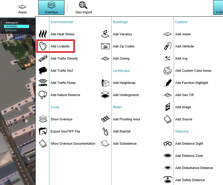
Select a grid overlay
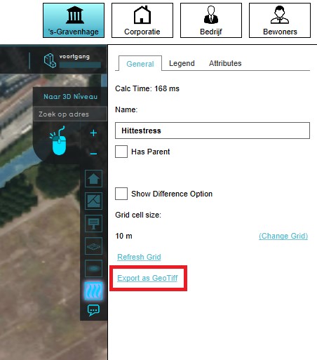
Select "Export Grid File"
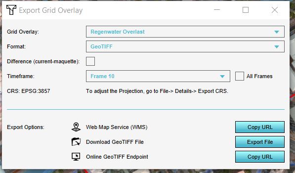
Choose the desired overlay to export, the ASCII format, if applicable the difference overlay and/or timeframe.


Notes
- There are three ASCII export formats:
- ASCII with CRS based DX/DY (accurate) - identical to GeoTIFF export. Instead of the cellsize parameter (which translates to square pixels), the dx/dy parameters are added.
- ASCII with square CELLSIZE in Meters (accurate) - the cellsize parameter of the ASCII file is the same as the set grid cell size.
- ASCII with square CRS CELLSIZE (approximation) - the raster data is rescaled and filled with NO_DATA values. This can cause a small deviation.
- When exporting Grid Overlays, take note of the grid cell size. The smaller the grid size, the more accurate the exported data is.
- If in a test run the option Difference (current - maquette) is selected, the difference in results between the maquette state and the current state will be exported. If you checked this option outside of the test run, or did not do any Actions yet, the exported dataset will consist no difference.
- For grid overlays which produce multiple timeframes as results, it is possible to export a dataset at a certain timeframe, by selecting the index of the timeframe. It is also possible to export all timeframes at once by checking the All frames box.