Advanced options (New Project Wizard): Difference between revisions
No edit summary |
|||
| Line 2: | Line 2: | ||
==What are advanced options== | ==What are advanced options== | ||
The advanced options allow you to make a selection which data sources you want to use for your project. | The advanced options allow you to make a selection which data sources you want to use for your project. It varies between the option to select or deselect a data source and change some settings like the resolution of data sources. | ||
==Where to find the advanced options== | ==Where to find the advanced options== | ||
| Line 8: | Line 8: | ||
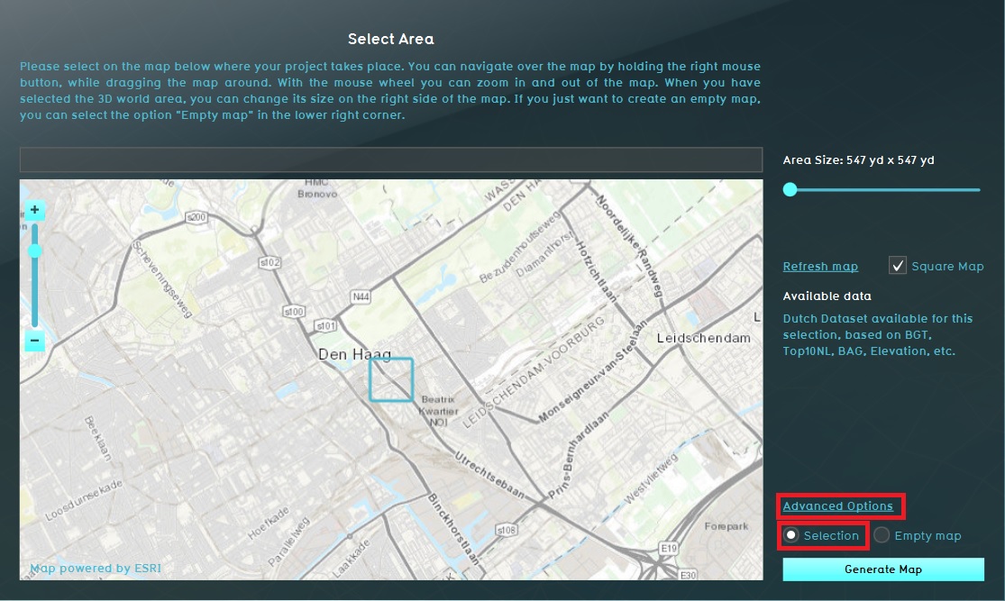
When choosing the location of the project area during the New project Wizard, in the second [[Panel | panel]] of the wizard, the default mode for data selection is ''Selection''. When this option is checked, the {{software}} will acquire datasets from a variety of public sources that are linked to the selected area. Roads and [[constructions]] will be placed according to the available data. Find an overview on which data is loaded into the {{software}} on the [[Project Sources]] page. On the [[GEO Data]] page an explanation is given on the different kinds of Geo Data and how to work with your own data sources. | When choosing the location of the project area during the New project Wizard, in the second [[Panel | panel]] of the wizard, the default mode for data selection is ''Selection''. When this option is checked, the {{software}} will acquire datasets from a variety of public sources that are linked to the selected area. Roads and [[constructions]] will be placed according to the available data. Find an overview on which data is loaded into the {{software}} on the [[Project Sources]] page. On the [[GEO Data]] page an explanation is given on the different kinds of Geo Data and how to work with your own data sources. | ||
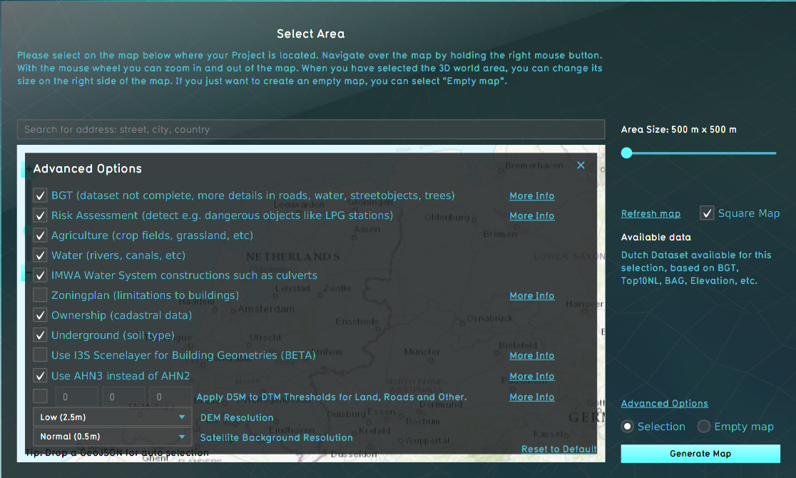
It is also possible to use the Advanced Options in this selection location step. When you open this option the list of data sources is displayed. You can choose to include or excluded specific data sources in your location selection. For example, you can choose to [[How to import i3s scene layer in new project|import I3S data]] in your project. Or change the satellite background resolution. | It is also possible to use the Advanced Options in this selection location step. When you open this option the list of data sources is displayed. You can choose to include or excluded specific data sources in your location selection. For example, you can choose to [[How to import i3s scene layer in new project|import I3S data]] in your project. Or change the satellite background resolution. | ||
==Examples of advanced options== | ==Examples of advanced options== | ||
[[File:Advanced_options_panel.jpg|right|400px|Area properties based on public data pertaining the selection (default)]] | |||
* The terrain height is one of the advanced options you can set. More informatio on how to do that is given on the [[Terrain_height#DTM_for_projects_in_The_Netherlands|Terrain Height page]] | * The terrain height is one of the advanced options you can set. More informatio on how to do that is given on the [[Terrain_height#DTM_for_projects_in_The_Netherlands|Terrain Height page]] | ||
* Also the option to use i3s is an advanced option. Read more on [[How_to_import_i3s_scene_layer_in_new_project|how to make use of i3s here]]. | * Also the option to use i3s is an advanced option. Read more on [[How_to_import_i3s_scene_layer_in_new_project|how to make use of i3s here]]. | ||
* An overview of all advanced data source options is given on the [[Project_Sources#Sources_connected_to_the_Tygron_Platform|project source page]]. | * An overview of all advanced data source options is given on the [[Project_Sources#Sources_connected_to_the_Tygron_Platform|project source page]]. | ||
Revision as of 15:29, 24 February 2020
What are advanced options
The advanced options allow you to make a selection which data sources you want to use for your project. It varies between the option to select or deselect a data source and change some settings like the resolution of data sources.
Where to find the advanced options
When choosing the location of the project area during the New project Wizard, in the second panel of the wizard, the default mode for data selection is Selection. When this option is checked, the Tygron Platform will acquire datasets from a variety of public sources that are linked to the selected area. Roads and constructions will be placed according to the available data. Find an overview on which data is loaded into the Tygron Platform on the Project Sources page. On the GEO Data page an explanation is given on the different kinds of Geo Data and how to work with your own data sources. It is also possible to use the Advanced Options in this selection location step. When you open this option the list of data sources is displayed. You can choose to include or excluded specific data sources in your location selection. For example, you can choose to import I3S data in your project. Or change the satellite background resolution.
Examples of advanced options
- The terrain height is one of the advanced options you can set. More informatio on how to do that is given on the Terrain Height page
- Also the option to use i3s is an advanced option. Read more on how to make use of i3s here.
- An overview of all advanced data source options is given on the project source page.

