Water Model Limits: Difference between revisions
No edit summary |
|||
| Line 2: | Line 2: | ||
The way this is calculated also has impact on practical use-cases. Below are 6 basics rules that need to be adhered to get a proper result. | The way this is calculated also has impact on practical use-cases. Below are 6 basics rules that need to be adhered to get a proper result. | ||
=Surface | =Surface Waterways= | ||
[[File:Raster_badflow.png|thumb|Grid cell to big for proper flow in channel]] | [[File:Raster_badflow.png|thumb|Grid cell to big for proper flow in channel]] | ||
Waterways are also calculated as 2D surface flow (not a 1D-line). This has several advantages, like interaction with the shoreline and creating detailed bathymetries. However is also requires a proper setup of the grid raster to get flow through waterway channel. | Waterways are also calculated as 2D surface flow (not a 1D-line). This has several advantages, like interaction with the shoreline and creating detailed bathymetries. However is also requires a proper setup of the grid raster to get flow through waterway channel. | ||
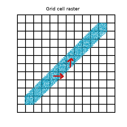
===1 The smallest waterway channel needs to be at least | ===1 The smallest waterway channel needs to be at least 8 cells wide=== | ||
* This is because water must be able to flow from cell to cell especially also when the watery runs in a diagonal angle to the square grid cells. | * This is because water must be able to flow from cell to cell especially also when the watery runs in a diagonal angle to the square grid cells. | ||
* So for example a | * So for example a 4m wide waterway channel (shoreline exclusive) needs to have 4/8 = ~0,5m grid cells. | ||
* When this rule is not adhered the [[Surface_model_(Water_Overlay)|surface theory]] leads to invalid water flow, causing no flow at all or a lower throughput (m3/s). | * When this rule is not adhered the [[Surface_model_(Water_Overlay)|surface theory]] leads to invalid water flow, causing no flow at all or a lower throughput (m3/s). | ||
* It may also result in a double shoreline effect where the bathymetry creates a small (partly underwater) levee in the channel with two adjacent opposing shorelines. The [[Surface_model_(Water_Overlay)|surface theory]] only supports one shoreline (partly flooded cell) direction per cell, this increases the height on the other side resulting in a small impulse that leads to water buildup over time (dutch "scheeftrekker" effect). | * It may also result in a double shoreline effect where the bathymetry creates a small (partly underwater) levee in the channel with two adjacent opposing shorelines. The [[Surface_model_(Water_Overlay)|surface theory]] only supports one shoreline (partly flooded cell) direction per cell, this increases the height on the other side resulting in a small impulse that leads to water buildup over time (dutch "scheeftrekker" effect). | ||
* See the [[Grid Overlay]] page on how to change the grid cell size. <br style="clear:both"> | * Note: to flow water between buildings in dense urban areas the same rules apply. | ||
* See the [[Grid Overlay]] page on how to change the grid cell size. When you have reached the smallest grid value (0,25m) you can also activate [[Increased_resolution_(Water_Overlay)]] under Advanced options, when activated only 4 cells are needed.<br style="clear:both"> | |||
===2 The elevation model (DEM) needs to be at least the same resolution === | ===2 The elevation model (DEM) needs to be at least the same resolution === | ||
| Line 20: | Line 21: | ||
= Impulse & Depth = | = Impulse & Depth = | ||
The calculation model is based on typical use cases and is therefor limited to the min/max values variables may take. Allow even larger min/max values is possible but has a drastic impact on performance and memory usage. | The calculation model is based on typical use cases and is therefor limited to the min/max values variables may take. Allow even larger min/max values is possible but has a drastic impact on performance and memory usage. When you do have a use-case that required different limits please let us know. | ||
===3 Water Depth=== | ===3 Water Depth=== | ||
| Line 27: | Line 28: | ||
===4 Water Speed=== | ===4 Water Speed=== | ||
* Water speed (m/s) is also limited to a maximum of 10m/s or 36kmph which is faster then a | * Water speed (m/s) is also limited to a maximum of 10m/s or 36kmph which is faster then a fast flowing river in mountainous terrain. | ||
= Breaches & Hydraulic structures = | = Breaches & Hydraulic structures = | ||
Revision as of 09:34, 28 May 2022
The water model is based on this theory. The way this is calculated also has impact on practical use-cases. Below are 6 basics rules that need to be adhered to get a proper result.
Surface Waterways
Waterways are also calculated as 2D surface flow (not a 1D-line). This has several advantages, like interaction with the shoreline and creating detailed bathymetries. However is also requires a proper setup of the grid raster to get flow through waterway channel.
1 The smallest waterway channel needs to be at least 8 cells wide
- This is because water must be able to flow from cell to cell especially also when the watery runs in a diagonal angle to the square grid cells.
- So for example a 4m wide waterway channel (shoreline exclusive) needs to have 4/8 = ~0,5m grid cells.
- When this rule is not adhered the surface theory leads to invalid water flow, causing no flow at all or a lower throughput (m3/s).
- It may also result in a double shoreline effect where the bathymetry creates a small (partly underwater) levee in the channel with two adjacent opposing shorelines. The surface theory only supports one shoreline (partly flooded cell) direction per cell, this increases the height on the other side resulting in a small impulse that leads to water buildup over time (dutch "scheeftrekker" effect).
- Note: to flow water between buildings in dense urban areas the same rules apply.
- See the Grid Overlay page on how to change the grid cell size. When you have reached the smallest grid value (0,25m) you can also activate Increased_resolution_(Water_Overlay) under Advanced options, when activated only 4 cells are needed.
2 The elevation model (DEM) needs to be at least the same resolution
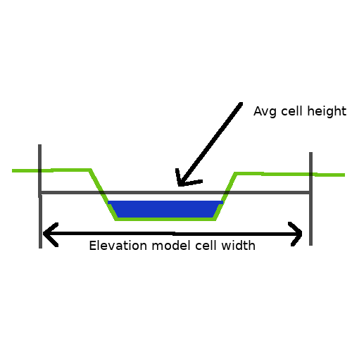
- For example when you have a 3m wide waterway channel and 0,5m grid cell, but the elevation model uses 10m cell accuracy all grid cells have the same (or interpolated height). Small elevation changes (like a waterway bathymetry) are lost in the average cell value.
- When this rule is not adhered the bathymetry becomes to shallow and water cannot flow properly. It can also result in overflow around shorelines because small levees are ignored.
- See the Advanced_options_(New_Project_Wizard) page on how to change the project DEM resolution when creating a new project and optionally uploading your own bathymetry DEM using the Geo_Data_tutorial.
Impulse & Depth
The calculation model is based on typical use cases and is therefor limited to the min/max values variables may take. Allow even larger min/max values is possible but has a drastic impact on performance and memory usage. When you do have a use-case that required different limits please let us know.
3 Water Depth
- Water depth (distance between bathymetry and water datum) is limited to max 100m. The water depth (h) is an important variable in the surface theory and having larger values increases the UV vector out of its accuracy and making the simulation unstable.
- Water depth also has a minimal value of 0,5 millimeter, a water depth less then 0,5 millimeter is ignored for the surface flow but is still counted in the overall water balance.
4 Water Speed
- Water speed (m/s) is also limited to a maximum of 10m/s or 36kmph which is faster then a fast flowing river in mountainous terrain.
Breaches & Hydraulic structures
Breaches and hydraulic structures are 1D objects that connect to the 2D grid.
5 Breach growth
- A breach that grows over time to 100m width also needs a breach area of at least 100m width. As the breach grows more 2D cells are used to flush the water from the 1D object onto the 2D grid. For proper flow the grid cells also need to be small enough, e.g. a breach of 20m width on a 100m grid cell cannot create stable breach growth. Typically at least 10 cells are needed for a breach thus 100m width needs at least 10m cell width.
- This may result in less flow through the weir or shock-waves as the breach increases in large steps.
6 Weir width
- Same as the breach a Weir or inlet can also flush the water on multiple cells, thus rule 1 must be adhered too. Furthermore a 100m wide Weir must also be in a waterway channel of at least 100m wide.
- Creating a Weir that is 100m wide on a 3m wide channel may cause water to flow over the shorelines or no flow at all due to DEM averaging (shoreline + bathymetry).

