Watershed Module overview: Difference between revisions
Jump to navigation
Jump to search
No edit summary |
(→Input) |
||
| Line 10: | Line 10: | ||
**[[Terrain Height|Digital terrain model (DTM)]]. | **[[Terrain Height|Digital terrain model (DTM)]]. | ||
* [[Culvert_(Water Overlay)|Culverts]] (Optional) | * [[Culvert_(Water Overlay)|Culverts]] (Optional) | ||
==Options== | |||
* Label remaining: Create additional discharge areas for water bodies that are not connected by culverts to discharge areas. | |||
* Fill distance: unmatched cells are assigned to nearest found discharge area when within the provided distance. | |||
==Result Types== | ==Result Types== | ||
Revision as of 14:56, 25 May 2020
Overview
Input
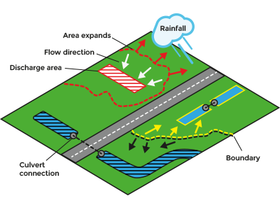
- Water terrains
- Discharge areas (Advised)
- Either:
- Water Overlay's surface flow direction result type;
- Digital terrain model (DTM).
- Culverts (Optional)
Options
- Label remaining: Create additional discharge areas for water bodies that are not connected by culverts to discharge areas.
- Fill distance: unmatched cells are assigned to nearest found discharge area when within the provided distance.


