Tygron for Scientific Research: Difference between revisions
| Line 75: | Line 75: | ||
#*Feedback regarding the game itself. | #*Feedback regarding the game itself. | ||
#Other researchers and stakeholders who were involved in the discussions and the sessions throughout the process. | #Other researchers and stakeholders who were involved in the discussions and the sessions throughout the process. | ||
<gallery mode="packed-overlay" heights=250px> | |||
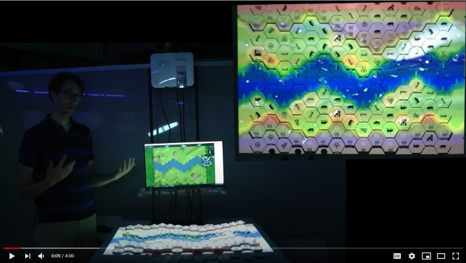
File:virtualriver1.png|The physical game board of the Virtual River game as a representation of a Dutch river segment | |||
File:virtualriver2.png|Virtual River game interface in the Tygron Geodesign platform | |||
</gallery> | |||
====Learning and using Tygron==== | ====Learning and using Tygron==== | ||
Revision as of 13:18, 25 March 2021
Use-case 4: “the Virtual River Game”
This page of the manual is still under development. The final version will be launched on April 8th 2021 during the EDU event 2021.
A PhD candidate at the University of Twente was assigned to create a serious gaming environment for river interventions as a tool that facilitates stakeholder engagement. The research was one among 15 projects as part of the RiverCare research program. The researcher is a human-centered interface designer, and is not an expert in river interventions. After developing and testing several prototypes, the researcher created the the virtual river game, a unique board-game that is digitally connected to the Tygron platform. To simulate river interventions, players can move the pieces on the board, and immediately see the changes on the Tygron screen including the new map, as well as numerical calculations and graphs corresponding to the board changes.

Content of the Research
General information
- The PhD Position:"A serious gaming environment for river interventions"
- Main Researcher:"Robert-Jan den Haan"
- Research Programme: RiverCare
- Department: Department of Design, Production & Management
- Educational Institute: Faculty of Engineering Technology of the University of Twente
- Involved Organisations: Rijkswaterstaat, Deltares, Witteveen+Bos, Arcadis, HKV, T-Xchange, TWO & Tygron Geodesign Platform
Background of the researcher
- Prior to this PhD, the researcher had a Masters in Industrial Design Engineering from the University of Twente.
- He had experience in design methods.
- The researcher did not have any prior experience in GIS, geo-design or coding.
- He had some limited programming base and he was pursuing a coding course along with his research.
- On the practical side, the researcher had tools and skills such as laser cutting and CAD drawing, which played a role while making the board.
Objectives and desired outcome
The main objective of this research was to create a virtual game that allows players to interact with an imaginary river section.
The game would allow different stakeholder groups to:
- learn about each others' perspectives regarding river management
- take better decisions of river interventions
- reflect upon the potential effects of those interventions
To do that, the researcher was expected to:
- develop and test a serious virtual game where players experience how river systems function.
- draft and publish a dissertation paper.
Research process
Research phases and time distribution
- The research meant to take a 4 years to be completed.
- Because the researcher was employed by the university 1 day/week, it took him 5 years to complete the research on a 4-days a week basis.
- That being said, the research started at the end of 2014 and ended at the end of 2019.
The research was developed based on a need-driven approach, therefore it consisted of:
- An initial research phase:
- this phase was very time-intensive, taking up to 3 years.
- it included intermediate prototypes.
- The development phase, taking up to 2 years:
- the researcher prototyped different games
- the researcher tested the prototypes with stakeholders.
- three prototypes were formally tested.
- A final testing phase at the end of the research:
- during this phase, 5 sessions were organized.
- all these sessions took place within 6 weeks.
- Although more sessions were to take place, they had to be cancelled due to the Covid-lockdown.
Resources & guidance
As mentioned earlier, the researcher did not have any prior knowledge in rivers, coding or the Tygron platform.
That is why, it is important to mention those who have helped the researcher create the river game:
- The supervisors of the research: professor in Human-centered Design and professor in Hydraulic Engineering
- Fedor Baart (one of the co-authors) from Deltares, contributed with his coding and modelling expertise.
- The Tygron team, who assisted the researcher in the following:
- Learning of Tygron.
- The connection of the board to the Tygron interface (API).
- Feedback regarding the game itself.
- Other researchers and stakeholders who were involved in the discussions and the sessions throughout the process.

The physical game board of the Virtual River game as a representation of a Dutch river segment

Virtual River game interface in the Tygron Geodesign platform


Learning and using Tygron
- The researcher has looked at several tookkits for game design, however he has chosen Tygron as it seemed the most applicable for his vision.
- Therefore, he had to learn how to use Tygron.
- The researcher also involved the Tygron team from the start.
- To do that, he visited the Tygron office for 2 full days in the very beginning so that he could:
- receive training on how to use the platform
- discuss with the team about what can and cannot be done using Tygron
- The researcher heavily relied on the web-based form of the API (Application Programmers Interface) as well as the support wiki.
- After that, he went back to Tygron to discuss the linkage between Tygron and the board game.
- To create the game, the researcher used the following data sources:
- Delft3D Flexible Mesh hydrodynamic model
- the BIOSAFE biodiversity model
- a self-developed "cost model" based on price estimation from research.


Making the Board Game
Coding - a lot of coding with Python as well as GIS Researcher relied on others for help with coding. Interviews with stakeholders in river management. Used solidworks to develop the physical board and the icons. Used the university laptop to create it, but dedicated the mini computer that could be carried. During that time, Tygron was developing the water module, so the researcher instead used a water model (Delft3D model) from Deltares which was CPU intensive. For Tygron, the laptop was okay, but the water model from Deltares was heavier A student assistant was hired to help with the creation of the board Colleagues and fellow researchers were also involved in the design and the evaluation phase (testing) Other 7 were involved in the research.
Budget was dedicated for mostly the dedicated computer, materials for the board, touch screen monitor, projector, webcam, wood material, etc.. as well as hiring the student assistant.
Outcome of the research
. As a concept idea we started to make a physical game board that represents a fictional and abstract part of the Dutch river. The game board is a spatial area divided into equal hexagonal locations. Each location is filled by two modular types of game stones: height and land use. For example, there are low stones to form the main channel of the river. Slightly higher stones, together with different land use, form stones as agricultural use, natural grassland and forest the floodplains. Even higher stones form the dikes.
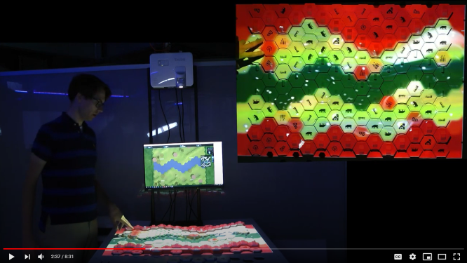
We have developed a game table and software around the game board that makes the physical game board digital. Through additional operations, we make the digital board suitable for the Delft3D Flexible Mesh hydrodynamic model, the BIOSAFE biodiversity model and a self-developed cost model. The digital board is also used to control the Tygron Platform. For example, players see the game board as a virtual world on the platform. Where the land use is agricultural on the board, players see cows grazing in the virtual world. Where the land use is forest on the board, the players see trees.
The outcome was already envisioned from the beginning- the game is not only the game but also where you play it. (digital + analogue) It was not necessarily the vision of the research consortium. They had a more scientific background and their vision was focused on getting a very realistic and complicated game, as close to reality as possible, however the researcher's vision was to make something based on the need, something that is useful.
The initial prototypes, the researcher translated real location into a board(east of nijmegen) For the final game, they took the characteristic of a dutch river and used it as a representation of a typical dutch river. (width, slope, depth, dykes'heights, etc.) So it is not a real location.
You can find the full research paper here: The Virtual River Game: Gaming using models to collaboratively explore river management complexity
You can find the summary poster of the project here: File:Summary poster - virtual river game.pdf
Feedback and recommendations
-The researcher recommends 3rd parties to create added value (what is actually needed) - Also involving 3rd parties is important for practical expertise and knowledge
Difficulties: the connection was a technical challenge - trial and error Expectation of the project partner of a very complicated looking game was a barrier Develop prototypes early on, even if it is only 2/10, then you can discuss on a baseline instead of something conceptual Once the prototype was playable, a baseline was created and discussions started.
Expectation management. Spend more time on thinking what should be developed, what could be done, what should not be done, what is possible, etc.
Some of the things were new for Tygron especially the connection
Contact
For more information about this PhD research, you can contact us at: info@Tygron.com
You can also contact Robert-Jan den Haan, researcher at the University of Twente at: r.j.denhaan@utwente.nl
| <<Previous page | Next page>> |