How to improve the estimated foliage overlay: Difference between revisions
Jump to navigation
Jump to search
No edit summary |
No edit summary |
||
| (7 intermediate revisions by the same user not shown) | |||
| Line 1: | Line 1: | ||
This how-to assumes you have followed the previous [[How to use a Infrared WMS to estimate foliage height|how-to]] on how to estimate foliage height using an Infrared WMS overlay. | This how-to assumes you have followed the previous [[How to use a Infrared WMS to estimate foliage height|how-to]] on how to estimate foliage height using an Infrared [[WMS Overlay]]. | ||
The how-to ends with a combo overlay that estimates the foliage height based on infra red images, a color filtering overlay and the subtraction of the surface and terrain height overlays. | |||
The resulting overlay provided a reasonable height for the tree trunks, but less for the branches of the trees. This how-to tries to improve the estimated foliage. | |||
<youtube>qk_5Qy1QkeM</youtube> | <youtube>qk_5Qy1QkeM</youtube> | ||
{{editor location|overlays|}} | {{editor location|overlays|}} | ||
{{editor steps|title= | {{editor steps|title= improve the estimated foliage overlay | ||
| | | Hover over Overlays in the ribbon bar, and under Grid Calculation select '''Average and Interpolation'''. | ||
| | | In the Average Overlay's detail panel, click on the ''Configuration Wizard'' button. | ||
| | | In the ''Operator'' step of the wizard, select the ''MAX'' option. | ||
| | | In the ''Type'' step select ''Input based on an other [[Grid Overlay]]''. | ||
| | | In the ''Overlay'' step select the Custom Foliage Height overlay that we created using the previous [[How to use a Infrared WMS to estimate foliage height|how-to]]. | ||
| | | Select finish to close the wizard. | ||
| | | In the Average Overlay's detail panel, select the Cell averaging distance field and provide the value '12'. | ||
| | | Click on the update now button to calculate the Average Overlay. | ||
| Hover over Overlays in the ribbon bar, and under Grid Calculation, select '''Combo'''. | |||
| | | In the combo Overlay's detail panel, select the name field and name it ''Improved Foliage Height''. | ||
| | | Select the combo box for ''Grid Input A'' and select the ''Custom Foliage Height'' Overlay. | ||
| | | Select the combo box for ''Grid Input B'' and select the ''Average Value'' Overlay. | ||
| Select the formula field and type the following formula: <code>IF(GT (A, 0) , B , 0)</code>. | |||
| Select the update now link to calculate the ''Improved Foliage Height''. | |||
}} | |||
{{gallery | |||
|how_to_custom_foliage_height.jpg|Estimated foliage height. | |||
|how_to_improved_foliage_height.jpg|Improved estimated foliage height. | |||
}} | }} | ||
{{article end | {{article end | ||
|notes= | |||
* The average distance of 12 meters is not set in stone, alternative average distances can be used. | |||
|howtos= | |howtos= | ||
*[[How to use a Infrared WMS to estimate foliage height]] | *[[How to use a Infrared WMS to estimate foliage height]] | ||
| Line 27: | Line 37: | ||
* [[Heat Overlay]] | * [[Heat Overlay]] | ||
}} | }} | ||
[[Category:How-to's]] | |||
Latest revision as of 15:30, 30 January 2024
This how-to assumes you have followed the previous how-to on how to estimate foliage height using an Infrared WMS Overlay. The how-to ends with a combo overlay that estimates the foliage height based on infra red images, a color filtering overlay and the subtraction of the surface and terrain height overlays. The resulting overlay provided a reasonable height for the tree trunks, but less for the branches of the trees. This how-to tries to improve the estimated foliage.
How to improve the estimated foliage overlay:
- Hover over Overlays in the ribbon bar, and under Grid Calculation select Average and Interpolation.
- In the Average Overlay's detail panel, click on the Configuration Wizard button.
- In the Operator step of the wizard, select the MAX option.
- In the Type step select Input based on an other Grid Overlay.
- In the Overlay step select the Custom Foliage Height overlay that we created using the previous how-to.
- Select finish to close the wizard.
- In the Average Overlay's detail panel, select the Cell averaging distance field and provide the value '12'.
- Click on the update now button to calculate the Average Overlay.
- Hover over Overlays in the ribbon bar, and under Grid Calculation, select Combo.
- In the combo Overlay's detail panel, select the name field and name it Improved Foliage Height.
- Select the combo box for Grid Input A and select the Custom Foliage Height Overlay.
- Select the combo box for Grid Input B and select the Average Value Overlay.
- Select the formula field and type the following formula:
IF(GT (A, 0) , B , 0). - Select the update now link to calculate the Improved Foliage Height.
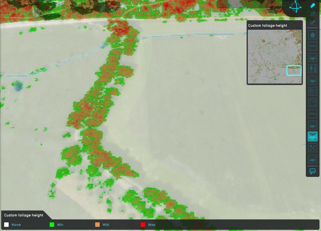
Estimated foliage height.
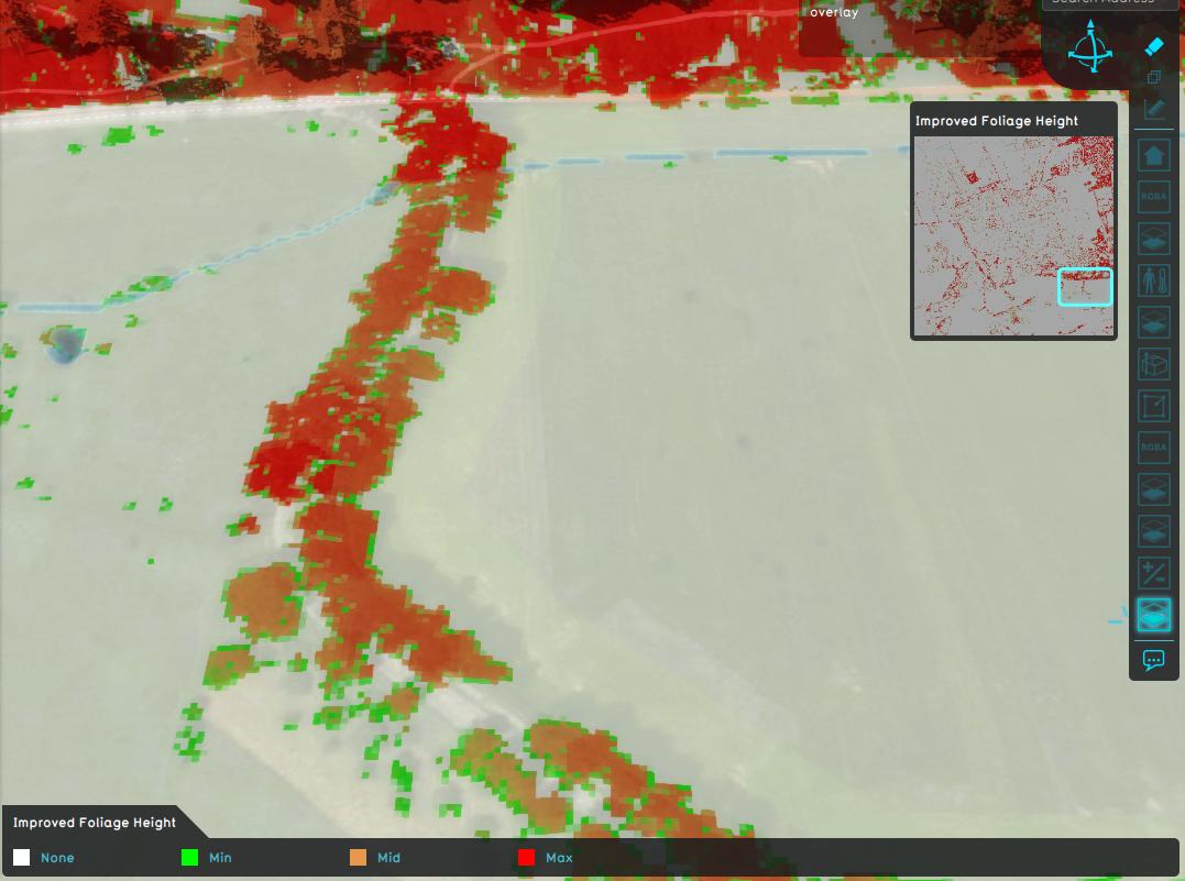
Improved estimated foliage height.


Notes
- The average distance of 12 meters is not set in stone, alternative average distances can be used.