Heat risk (Indicator): Difference between revisions
No edit summary |
No edit summary |
||
| Line 7: | Line 7: | ||
* heat stress and the effct on citizens is measured | * heat stress and the effct on citizens is measured | ||
* livability is an important goal | * livability is an important goal | ||
===Indicator panel=== | |||
[[File:Heat_risk_panel.JPG|400px|right]] | |||
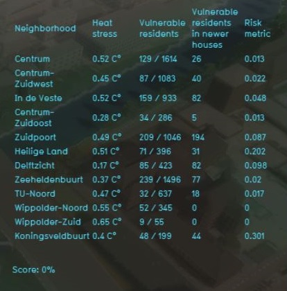
The indicator panel (see the image on the right) shows in a table per [[Neighborhoods|neighborhood]]: | |||
* the neighborhood name | |||
* the average heat stress | |||
* the amount of elderly people (65 years and older) and the total amount of people living in this neighborhood | |||
* the amount of elderly people that are living in new build houses | |||
* the risk assigned to this neighborhood. The highter the number, the higher the heat risk is. | |||
===Calculation=== | ===Calculation=== | ||
First the heat stress in an area is calculated | First the heat stress in an area is calculated. Then the amount of 65 year and older people are counted for each neighborhood. The amount of [[Units|houses]] after 2012 are counted as new build houses. The risk is then calculated as: | ||
risk = Percentage elderly people x the heat stress in degrees. | risk = Percentage elderly people x the heat stress in degrees. | ||
====Score==== | ====Score==== | ||
The score is represented in a progress bar, with a scale from 0 to 100%. | The score is represented in a progress bar, with a scale from 0 to 100%. | ||
==Additional configurations== | ==Additional configurations== | ||
For this indicator to function, only the [[Heat_(Overlay)|heat stress overlay]] has to be added to the project, see below for the steps. However, due to the reliance on [[GEO_Data|CBS data]] which is a dataset for the Netherlands, the indicator will only function on projects located in the Netherlands. | For this indicator to function, only the [[Heat_(Overlay)|heat stress overlay]] has to be added to the project, see below for the steps. However, due to the reliance on [[GEO_Data|CBS data]] which is a dataset for the Netherlands, the indicator will only function on projects located in the Netherlands. | ||
=== | ===add the [[Heat_(Overlay|Heat stress overlay]]=== | ||
When the indicator is added to the project, an error message is given. To solve this, the heat stress overlay has to be added. | When the indicator is added to the project, an error message is given. To solve this, the heat stress overlay has to be added. | ||
{{Editor steps|title=add the Heat stress Overlay|Select ''Geo data'' and then ''Overlays'' in the ribbon header|Select the Heat stress Overlay from the hover panel.}} | {{Editor steps|title=add the Heat stress Overlay|Select ''Geo data'' and then ''Overlays'' in the ribbon header|Select the Heat stress Overlay from the hover panel.}} | ||
Revision as of 10:54, 27 February 2019
General
What is the heat risk indicator?
The heat risk indicator calculates a metric for the risk to vulnerable citizens due to heat stress. Heat stress is .. It correlates information on residents over 65 years old from CBS data, the Heatstress Overlay and the amount of new build houses. In this indicator it is assumed that new build houses have better isolation and therefore facilitates better heat retention. This indicator is for example useful for projects in where:
- heat stress and the effct on citizens is measured
- livability is an important goal
Indicator panel
The indicator panel (see the image on the right) shows in a table per neighborhood:
- the neighborhood name
- the average heat stress
- the amount of elderly people (65 years and older) and the total amount of people living in this neighborhood
- the amount of elderly people that are living in new build houses
- the risk assigned to this neighborhood. The highter the number, the higher the heat risk is.
Calculation
First the heat stress in an area is calculated. Then the amount of 65 year and older people are counted for each neighborhood. The amount of houses after 2012 are counted as new build houses. The risk is then calculated as: risk = Percentage elderly people x the heat stress in degrees.
Score
The score is represented in a progress bar, with a scale from 0 to 100%.
Additional configurations
For this indicator to function, only the heat stress overlay has to be added to the project, see below for the steps. However, due to the reliance on CBS data which is a dataset for the Netherlands, the indicator will only function on projects located in the Netherlands.
add the Heat stress overlay
When the indicator is added to the project, an error message is given. To solve this, the heat stress overlay has to be added.
- Select Geo data and then Overlays in the ribbon header
- Select the Heat stress Overlay from the hover panel.
