Foliage height calculation model (Heat Overlay): Difference between revisions
| Line 17: | Line 17: | ||
# For each grid cell i, each surrounding cell j within a search range of 100 meters is checked for a foliage height. | # For each grid cell i, each surrounding cell j within a search range of 100 meters is checked for a foliage height. | ||
# In case the foliage height > 0, and the grid cell i is within range of the foliage diameter of cell j, the calculated foliage height for cell i is based on the distance from the center of the tree and a linear declining foliage height. The linear decline is 1:1 and currently cannot be set to a different decline. See the image below. | # In case the foliage height > 0, and the grid cell i is within range of the foliage diameter of cell j, the calculated foliage height for cell i is based on the distance from the center of the tree and a linear declining foliage height. The linear decline is 1:1 and currently cannot be set to a different decline. See the image below. | ||
# The maximum foliage height is eventually stored as the foliage height of that cell. | |||
[[File:Foliage_crown_factor.png|400px]][[File:Foliage_top.png|400px]] | [[File:Foliage_crown_factor.png|400px]][[File:Foliage_top.png|400px]] | ||
==Notes== | ==Notes== | ||
* Since the decline of the foliage height cannot be changed, it will always be linear. There are options to expand and improve this in the future. | * Since the decline of the foliage height cannot be changed, it will always be linear. There are options to expand and improve this in the future. | ||
Revision as of 09:17, 20 September 2019
Knowing where the foliage is present and at what height it is situated for each grid cell of a Heat Overlay is an important factor for the Shade and Skyview calculation models.
The Foliage Height for each grid cell can be determined in three ways:
- By supplying the areas which each hold the height of foliage for the whole polygon of a particular area.
- By supplying a geotiff which holds the foliage heights as a grid.
- By using the foliage functions and their height and foliage crown factor function value.
The mentioned options are currently exclusive; Only one option will determine the foliage height and they currently cannot be combined.
It depends on the available data and the use case which option you will choose as a user. When developing future scenario's in which other users can add foliage to unknown location, it is advised to use the Foliage crown factor option.
Rasterization
The foliage height is rasterized using the grid rasterization algorithm when the foliage height is obtained from areas or geotiffs. In case the foliage height is determined using the foliage crown factor, it works as followed:
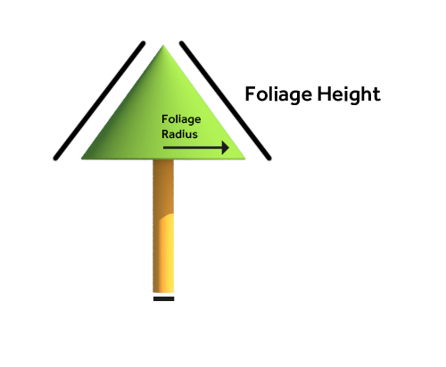
- For each grid cell, the foliage diameter is calculated by multiplying the foliage height with the foliage crown factor.
- This diameter and foliage height is stored for each grid cell.
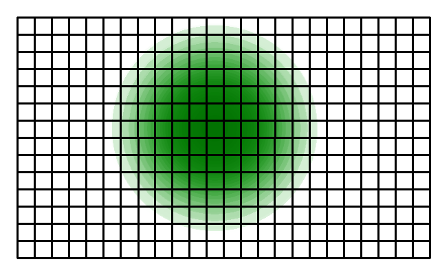
- For each grid cell i, each surrounding cell j within a search range of 100 meters is checked for a foliage height.
- In case the foliage height > 0, and the grid cell i is within range of the foliage diameter of cell j, the calculated foliage height for cell i is based on the distance from the center of the tree and a linear declining foliage height. The linear decline is 1:1 and currently cannot be set to a different decline. See the image below.
- The maximum foliage height is eventually stored as the foliage height of that cell.
Notes
- Since the decline of the foliage height cannot be changed, it will always be linear. There are options to expand and improve this in the future.

