Project area: Difference between revisions
No edit summary |
|||
| (13 intermediate revisions by the same user not shown) | |||
| Line 1: | Line 1: | ||
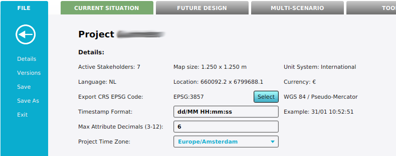
[[File:Project_details.png|thumb|500px|The project details showing the Map size and the Location (World reference Point) of a [[project]]]] | |||
The project area is the rectangular data space of your project. It is defined by a width and a height. Its location is defined by a world reference point, which is a coordinate relative to the [https://epsg.io/3857|EPSG:3857 WGS 84 / Pseudo-Mercator] coordinate system. | The project area is the rectangular data space of your project. It is defined by a width and a height. Its location is defined by a world reference point, which is a coordinate relative to the [https://epsg.io/3857|EPSG:3857 WGS 84 / Pseudo-Mercator] coordinate system. | ||
| Line 4: | Line 5: | ||
The world reference point is stored in the WORLD_REFERENCE_POINT Setting item as an array of two Doubles, representing X and Y. | The world reference point is stored in the WORLD_REFERENCE_POINT Setting item as an array of two Doubles, representing X and Y. | ||
When a project is generated, or new features are imported or drawn in a session, they are required to intersect with the project area. Only its intersection with this project area is imported. This holds for practically all [[item]]s, with the exception of [[Height Sector]]s and [[Terrain]]s.<br clear=both> | |||
When a project is generated, or new features are imported or drawn in a session, they are required to intersect with the project area. Only its intersection with this project area is imported. This holds for practically all [[item]]s, with the exception of [[Height Sector]]s and [[Terrain]]s. | |||
==Surrounding Map Bounds== | ==Surrounding Map Bounds== | ||
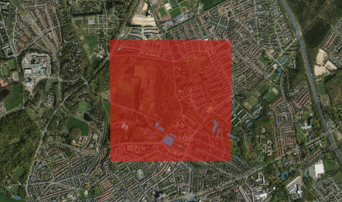
[[File:Project_surrounding_map.png|thumb|500px|The project area (red) and its surrounding map (satellite). Notice the satellite images and its corresponding [[height sector]]s and severally water bodies as [[terrain]]s.]] | |||
When zooming out to view the [[project area]], you 'll notice that there is a region surrounding the project area that is covered with satellite images, Height sector information and terrain data. These provide some extra sense of orientation and lead to a more pleasantly looking boundary of your project. | When zooming out to view the [[project area]], you 'll notice that there is a region surrounding the project area that is covered with satellite images, Height sector information and terrain data. These provide some extra sense of orientation and lead to a more pleasantly looking boundary of your project. | ||
The surrounding map extend is stored as a setting, SURROUNDING_MAP_EXTEND_M, which defines the extra boundary distances around the project area. Its total dimensions are calculated as: | The surrounding map extend is stored as a setting, SURROUNDING_MAP_EXTEND_M, which defines the extra boundary distances around the project area. Its total dimensions are calculated as: | ||
<math> x_s = d_x \cdot 2 + x_m \\ | <math>\begin{align} | ||
y_s = d_y \cdot 2 + y_m</math> | x_s & = d_x \cdot 2 + x_m \\ | ||
y_s & = d_y \cdot 2 + y_m | |||
\end{align}</math> | |||
where: | where: | ||
<math>x_s \text{and} y_s</math> are the dimensions of the surrounding map extends | :<math>x_s \text{ and } y_s</math> are the dimensions of the surrounding map extends. | ||
<math>d_x \text{and} d_y</math> are the configured distances around the project area, stored in the setting SURROUNDING_MAP_EXTEND_M. | :<math>d_x \text{ and } d_y</math> are the configured distances around the project area, stored in the setting SURROUNDING_MAP_EXTEND_M. | ||
<math>x_m \text{and} y_m</math> are the project area dimensions, stored in the setting MAP_SIZE_M. | :<math>x_m \text{ and } y_m</math> are the project area dimensions, stored in the setting MAP_SIZE_M. | ||
Latest revision as of 10:17, 31 January 2023

The project area is the rectangular data space of your project. It is defined by a width and a height. Its location is defined by a world reference point, which is a coordinate relative to the WGS 84 / Pseudo-Mercator coordinate system.
The width and height are stored in the MAP_SIZE_M Setting item as an array of two Integers, representing the width and height. The world reference point is stored in the WORLD_REFERENCE_POINT Setting item as an array of two Doubles, representing X and Y.
When a project is generated, or new features are imported or drawn in a session, they are required to intersect with the project area. Only its intersection with this project area is imported. This holds for practically all items, with the exception of Height Sectors and Terrains.
Surrounding Map Bounds

When zooming out to view the project area, you 'll notice that there is a region surrounding the project area that is covered with satellite images, Height sector information and terrain data. These provide some extra sense of orientation and lead to a more pleasantly looking boundary of your project.
The surrounding map extend is stored as a setting, SURROUNDING_MAP_EXTEND_M, which defines the extra boundary distances around the project area. Its total dimensions are calculated as:
where:
- are the dimensions of the surrounding map extends.
- are the configured distances around the project area, stored in the setting SURROUNDING_MAP_EXTEND_M.
- are the project area dimensions, stored in the setting MAP_SIZE_M.


