Aerius Module: Difference between revisions

From Tygron Support wiki
Jump to navigation Jump to search
No edit summary
No edit summary
 
(30 intermediate revisions by 6 users not shown)
Line 1: Line 1:
{{Template:Aerius Module buttons}}
{{unavailable}}
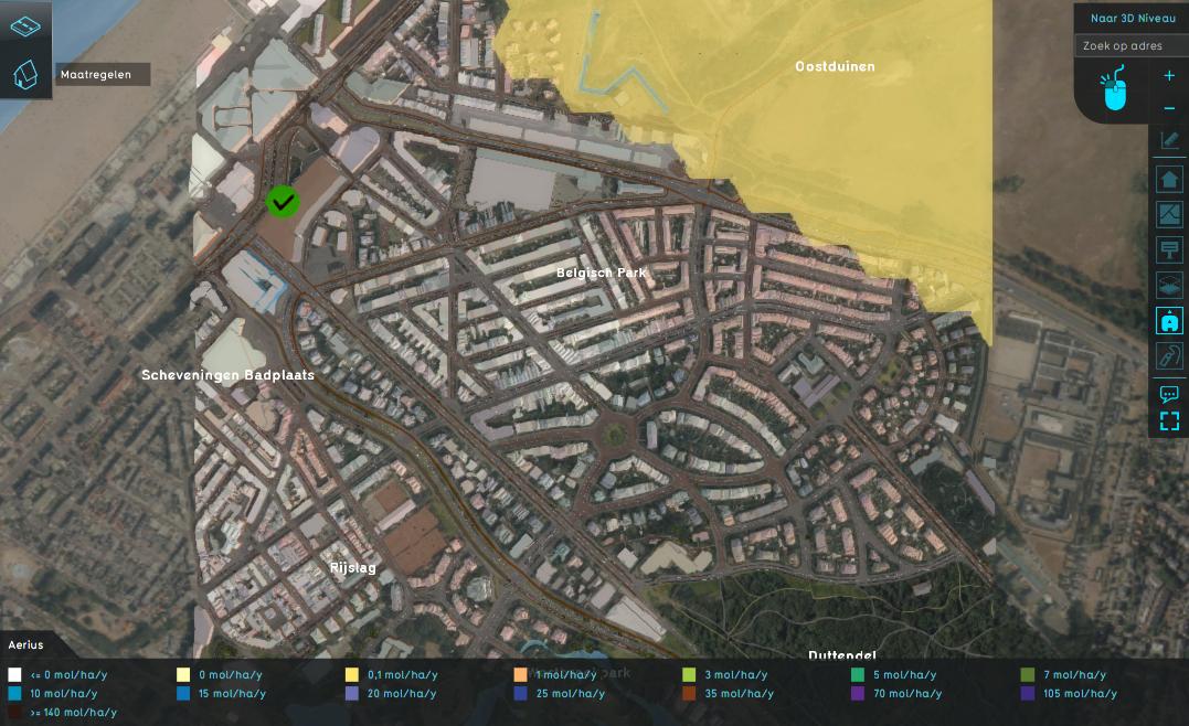
[[File:nox_result_type.jpeg|thumb|420px|right|Example of the Aerius Overlay NOX result type]]__NOTOC__
{{Aerius Module buttons}}
The Aerius module identifies NOX- and NH3-emitting features and sends these to the [https://connect.aerius.nl/api/doc/ AERIUS Connect Api] to calculate its emissions and NOX and NH3 pollution on Natura 2000 areas.
[[File:nox_result_type.jpeg|thumb|420px|right|link=https://youtu.be/2ib4KZ_ji6k|Video of the [[Aerius Overlay]] (Dutch only)]]
The Aerius module calculates NOX and NH3 deposition on Natura 2000 areas (in the Netherlands) by using the [https://connect.aerius.nl/api/doc/ AERIUS Connect Api], version 2020. Via this API, calculations can be executed directly on the calculation heart of the [https://calculator.aerius.nl/calculator/ Aerius Calculator].
The Aerius module can for example be used for the following scenarios:
* Calculate the emissions and nitrogen deposition on Natura 2000 areas for a new building, based on the type, size and way of heating of/in the building.
* Calculate emissions and nitrogen deposition on Natura 2000 areas for the construction and usage of new roads, based on the increase of traffic per traffic category and type of road
* Calculate and visualize the emissions and nitrogen deposition for the different phases (construction phase and usage phase) of a new building plan.


==Aerius applications==
The Aerius module can be used for the following:
* Calculate emissions for roads based on the type of road and the number of vehicles per category.
* Calculate the emissions for planned constructions, based on the construction machines and material used and the created appartments, houses and office space.
* Calculate the pollution of NOX and NH3 on nearby Natura 2000 areas.


==Considerations==
{{article end
* Only buildings are processed for specific attributes such as number of light traffic, create surface office and shop space, used fuel per year for construction and direct emissions of NOX and NH3.
|seealso=
* Per sector these attributes are converted to individual Aerius features. These features are encoded using the GML-format, which is the primary data format the AERIUS Connect Api accepts.
* [[Aerius Overlay]]
* A single building can therefore be send as multiple features, one for each sector. For some types of feature, the Aerius Connect Api calculates NOX- and NH3-emission values, which are written back into the building
}}
* Only the sum of NOX emissions is stored per building, not per sector. NH3 emissions likewise.
* NOX and NH3 pollution is returned by the Aerius Connect Api as hexagon features, which are stored in the Aerius overlay's grid. Only when Natura 2000 areas are inside the project bounds, these hexagons can be seen. The array of individual emission values are also stored in the Aerius overlay under the NOX and NH3 attribute respectively.
* Depending on the amount of features send to the Aerius Connect Api, the calculation jobs can take considerable time. The Aerius module stops waiting for a job after 5 minutes.
 
==Concept==
# Existing or to be constructed buildings create NOX and NH3 emissions. These emissions also possibly pollute Natura 2000 areas.
# The emissions are categorized by Aerius into sectors and sub types within these sectors.
# Each sector has its own feature description, for which Aerius can calculate the corresponding emissions.
# A {{software}} session represents a single situation in an Aerius calculation. This means that the Natura 2000 pollution is calculated for the current state of the project session, not per individual feature.
 
==Calculation==
# Buildings are converted into one or more GML features identifiable by the Aerius Connect Api.
# These features are represented as a line for roads or a center-point otherwise.
# These features are combined into a collection and put in a situation feature.
# This situation is send to the Aerius Connect Api and a calculation job is started
# This job is polled until completed.
# When completed, the calculation results are retrieved and processed.
# Emissions for the various features (roads, construction plans, construction machines) related to a building are summed up and stored under the [[NOX_(Aerius_Overlay)|NOX]] and [[NOX_(Aerius_Overlay)|NH3]] [[keys]] for that building.
# Natura 2000 Hexagon polygons are converted to grid cells with their respective NOX and NH3 mol/ha/year values.
# Natura 2000 Hexagon polygons values are also stored as an array in the Aerius Overlay under the NOX and NH3 keys.
 
==See Also==
* [[Aerius (Overlay)|Aerius Overlay]]

Latest revision as of 13:55, 3 November 2023

This functionality is currently unavailable or non-functional.


Video of the Aerius Overlay (Dutch only)

The Aerius module calculates NOX and NH3 deposition on Natura 2000 areas (in the Netherlands) by using the AERIUS Connect Api, version 2020. Via this API, calculations can be executed directly on the calculation heart of the Aerius Calculator. The Aerius module can for example be used for the following scenarios:

  • Calculate the emissions and nitrogen deposition on Natura 2000 areas for a new building, based on the type, size and way of heating of/in the building.
  • Calculate emissions and nitrogen deposition on Natura 2000 areas for the construction and usage of new roads, based on the increase of traffic per traffic category and type of road
  • Calculate and visualize the emissions and nitrogen deposition for the different phases (construction phase and usage phase) of a new building plan.


See also