How to open the Project Sources table: Difference between revisions
Jump to navigation
Jump to search
No edit summary |
(→Note) |
||
| (2 intermediate revisions by the same user not shown) | |||
| Line 1: | Line 1: | ||
[[File:Building_source_hyperlink.png|right | [[File:Building_source_hyperlink.png|right]] | ||
[[File:Project_sources_table.JPG|right|400px]] | [[File:Project_sources_table.JPG|right|400px]] | ||
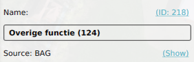
{{Editor steps|title=show the project sources table|Select a type of spatial [[Item]], such as a [[Building]] in the editor Current situation| Click on the 'Show' hyperlink next to its [[Source]]'}} | {{Editor steps|title=show the project sources table|Select a type of spatial [[Item]], such as a [[Building]] in the editor Current situation| Click on the 'Show' hyperlink next to its [[Source]]'}} | ||
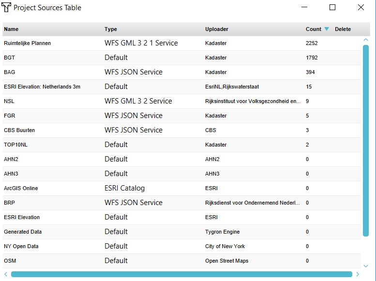
The project sources table shows the used [[GEO_Data|Geo data]] sets in the | The project sources table shows the used [[GEO_Data|Geo data]] sets in the project and the by a user imported data. | ||
The table shows: | The table shows: | ||
*the name of the dataset | *the name of the dataset | ||
| Line 10: | Line 10: | ||
*the publisher of the dataset | *the publisher of the dataset | ||
*the number of features in the 3D model (count). | *the number of features in the 3D model (count). | ||
{{article end | |||
If the count is 0, this means the | |notes= | ||
If the count is 0, this means the items in your project do not reference the source. If the data is a raster dataset, which technically does not contain features, but cells with a value, the value will be 1. | |||
|seealso= | |||
* [[Source]]s | |||
}} | |||
[[Category:Source]][[Category:How-to's]] | |||
Latest revision as of 15:52, 30 January 2024


How to show the project sources table:
The project sources table shows the used Geo data sets in the project and the by a user imported data. The table shows:
- the name of the dataset
- the type
- the publisher of the dataset
- the number of features in the 3D model (count).
Notes
If the count is 0, this means the items in your project do not reference the source. If the data is a raster dataset, which technically does not contain features, but cells with a value, the value will be 1.