Ground water depth formula (Subsidence Overlay): Difference between revisions
| Line 23: | Line 23: | ||
====Ground water level managed by water level areas==== | ====Ground water level managed by water level areas==== | ||
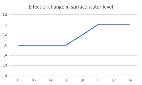
[[File:ground-water-graph.jpg|400px|thumb|right|The effect of changes of managed surface water levels (by water level areas) on the ground water level. The x-axis indicates the relative depth of the managed surface water level. The y-axis indicates the meters of change to the ground water level, per meter change in surface water level. The smaller the relative depth is, the less the ground water level equalizes with changes in the managed surface water level.]] | [[File:ground-water-graph.jpg|400px|thumb|right|The effect of changes of managed surface water levels (by water level areas) on the ground water level. The x-axis indicates the relative depth of the managed surface water level. The y-axis indicates the meters of change to the ground water level, per meter change in surface water level. The smaller the relative depth is, the less the ground water level equalizes with changes in the managed surface water level.]] | ||
The ground water level | The ground water level can also be managed by water level areas, which control the surface water levels. The ground water level increments can be calculated based on the indexation on the managed water level of surface water and the calculated subsidence of the previous year. This increment in ground water level is rarely exactly the adjustment of the managed surface water level and is often less, depending on the relative depth of the surface water level. The following formulas have been developed to estimate the increase of the ground water level. | ||
<math>\Delta{d_{a,s,y}} = \Delta{d_{low}}+\Delta{d_{mid}}+\Delta{d_{high}}</math> | <math>\Delta{d_{a,s,y}} = \Delta{d_{low}}+\Delta{d_{mid}}+\Delta{d_{high}}</math> | ||
Revision as of 13:23, 9 February 2021
At the start of a simulation, the ground water depth is initialized with the ground water depth geotiff (if provided) and is optionally overwritten by (managed) water level areas' water level. Furthermore, the ground water level can be managed with drainages (provided as underground buildings), either actively or passively.
Additionally the terrain height can change due to subsidence that occurred in previous years and due to actions taken that raised the terrain. Managed water level areas can react to these changes when indexation is configured. For indexation, see indexation formula.
Ground water level managed by drainages
where
- is the calculated ground water depth of a grid cell at year y.
- is the ground water depth actively maintained by a drainage
- is the ground water depth of the managed water level area.
- is the area water level adjustment for year y.
- is the ground water level passively maintained by drainages.
- is the ground water level increase calculated based on the are water level adjustment due to indexation and the subsidence in the previous year.
Ground water level managed by water level areas

The ground water level can also be managed by water level areas, which control the surface water levels. The ground water level increments can be calculated based on the indexation on the managed water level of surface water and the calculated subsidence of the previous year. This increment in ground water level is rarely exactly the adjustment of the managed surface water level and is often less, depending on the relative depth of the surface water level. The following formulas have been developed to estimate the increase of the ground water level.


