GeoShare: Difference between revisions
No edit summary |
|||
| (36 intermediate revisions by 5 users not shown) | |||
| Line 1: | Line 1: | ||
The {{geoshare}} is a shared central repository for files and (geographical) data, hosted on the {{software}}. It is linked to an individual [[Domain]], but exists separate from active [[Session]]s. This allows for the sharing of data, either input data or results from calculations, without the overhead of a full [[Project]]'s data or a running [[Session]]. In addition to geographical data, the | The {{geoshare}} is a shared central repository for files and (geographical) data, hosted on the {{software|server}}. It is linked to an individual [[Domain]], but exists separate from active [[Session]]s. This allows for the sharing of data, either input data or results from calculations, without the overhead of a full [[Project]]'s data or a running [[Session]]. In addition to geographical data, the {{geoshare}} can also host other files which can be used as [[asset]]s in a [[Project]]. | ||
The | The {{geoshare}} supports uploading, downloading, renaming and deleting files, as well as setting up a file structure to organize them. | ||
The | The {{geoshare}} can be accessed directly from the [[main menu]]. All users with [[Editor (User Account Type)|Editor rights]] can access and update all files on the {{geoshare}}. | ||
==Access== | ==Access== | ||
Files uploaded to the | Files uploaded to the {{geoshare}} can be accessed via a url. The url allows anyone to access the file at any time. The url can be used in a webbrowser to initiate a download of the file (or provide an in-browser overview of the contents of a directory). | ||
On a per-file and per-directory basis, it is possible to set a required access token. Although to access a file or directory a url must be known in the first place, requiring an access token provides an additional secret which must be known in order to access the data. | On a per-file and per-directory basis, it is possible to set a required access token. Although to access a file or directory a url must be known in the first place, requiring an access token provides an additional secret which must be known in order to access the data. | ||
When a directory is accessed in a web browser, all direct contents of the directory are displayed, including those which actually also require an access token. However, only contents which do ''not'' require an access token can be directly accessed from that overview. | When a directory is accessed in a web browser, all direct contents of the directory are displayed, including those which actually also require an access token. However, only contents which do ''not'' require an access token can be directly accessed from that overview. | ||
==Public Share== | |||
There is also a public section on the {{geoshare}} that is accessible for all users in all domains. The public {{geoshare}} can for example be used to share publicly available default Indicators or example files. Please contact Tygron support to submit proposals for new content on the public {{geoshare}}. | |||
The public {{geoshare}} can be accessed via the toggle button in the upper right corner of the {{geoshare}} panel. | |||
<gallery> | |||
File:PublicShareToggleButton1.jpg|Toggle button to access Public Share. | |||
File:Share_public_indicators.png|Indicators section on the {{Public Share}} | |||
</gallery> | |||
==Files== | ==Files== | ||
The | The {{geoshare}} is primarily intended to host geographical data, either for the purpose of standardized input for the creation of [[Project]]s, or to host the results of performed calculations in an easily accessible way without the need to keep a [[Session]] active or even a complete [[Project]]. However, other files can be hosted on the {{geoshare}} as well, with a focus on files which can be used as [[asset]]s in a [[Project]] such as [[Excel]]s. | ||
The | The {{geoshare}} supports the following filetypes: | ||
{|class=wikitable | {|class=wikitable | ||
! Filetype | ! Filetype | ||
! Name | |||
! Type of data | ! Type of data | ||
! Input | ! Input | ||
| Line 23: | Line 33: | ||
|- | |- | ||
| .cityjson | | .cityjson | ||
| 3D | | [[GeoJSON]] | ||
| Import as [[ | | 3D visualization data | ||
| Import as [[Custom Geometries]] for [[Building]]s | |||
| | | | ||
|- | |- | ||
| .csv | | .csv | ||
| [[CSV]] | |||
| Text-based list of values | | Text-based list of values | ||
| | | | ||
| Line 33: | Line 45: | ||
|- | |- | ||
| .docx | | .docx | ||
| | |||
| Document | | Document | ||
| | | | ||
| | |||
|- | |||
| .dxf | |||
| [[DXF]] | |||
| AutoCAD exchange format | |||
| Import as [[Building]]s, [[Area]]s, etc | |||
| | | | ||
|- | |- | ||
| .geojson | | .geojson | ||
| [[GeoJSON]] | |||
| 2D Vector data | | 2D Vector data | ||
| Import as [[ | | Import as [[Building]]s, [[Area]]s, etc | ||
| Export of Vector data | | Export of Vector data | ||
|- | |- | ||
| .gif | | .gif | ||
| | |||
| Animated image | | Animated image | ||
| | | | ||
| Line 48: | Line 69: | ||
|- | |- | ||
| .gml | | .gml | ||
| | |||
| XML data | | XML data | ||
| | | | ||
| Line 53: | Line 75: | ||
|- | |- | ||
| .jpeg | | .jpeg | ||
| | |||
| Image | | Image | ||
| | | | ||
| Line 58: | Line 81: | ||
|- | |- | ||
| .jpg | | .jpg | ||
| | |||
| Image | | Image | ||
| | | | ||
| Line 63: | Line 87: | ||
|- | |- | ||
| .json | | .json | ||
| 2D Vector data | | [[GeoJSON]] | ||
| Import as [[ | | 2D and 3D Vector data | ||
| Import as [[Building]]s, [[Area]]s, etc | |||
| | | | ||
|- | |- | ||
| .pdf | | .pdf | ||
| | |||
| Document | | Document | ||
| | | | ||
| Line 73: | Line 99: | ||
|- | |- | ||
| .png | | .png | ||
| | |||
| Image | | Image | ||
| | | | ||
| Line 78: | Line 105: | ||
|- | |- | ||
| .slpk | | .slpk | ||
| 3D | | [[SLPK]] | ||
| Import as [[ | | 3D visualization data | ||
| Import as [[Custom Geometries]] for [[Building]]s | |||
| | | | ||
|- | |- | ||
| .tif | | .tif | ||
| [[GeoTIFF]] | |||
| Grid data | | Grid data | ||
| [[GeoTIFF Overlay]], [[Elevation model]], other grid data | | [[GeoTIFF Overlay]], [[Elevation model]], other grid data | ||
| Line 88: | Line 117: | ||
|- | |- | ||
| .tiff | | .tiff | ||
| [[GeoTIFF]] | |||
| Grid data | | Grid data | ||
| [[GeoTIFF Overlay]], [[Elevation model]], other grid data | | [[GeoTIFF Overlay]], [[Elevation model]], other grid data | ||
| Line 93: | Line 123: | ||
|- | |- | ||
| .txt | | .txt | ||
| | |||
| Text | | Text | ||
| | | | ||
| Line 98: | Line 129: | ||
|- | |- | ||
| .xlsx | | .xlsx | ||
| [[Excel]] | |||
| [[Excel]] | | [[Excel]] | ||
| Assets for [[Indicator]]s, [[Panel]]s, etc | | Assets for [[Indicator]]s, [[Panel]]s, etc | ||
| Line 103: | Line 135: | ||
|- | |- | ||
| .xml | | .xml | ||
| | |||
| XML data | | XML data | ||
| | | | ||
| Line 110: | Line 143: | ||
==Viewers== | ==Viewers== | ||
{{main|GeoShare Viewer}} | {{main|GeoShare Viewer}} | ||
Besides the ability to serve "raw" files, it is possible to create a "viewer" on the | Besides the ability to serve "raw" files, it is possible to create a "viewer" on the {{geoshare}}. Viewers allow for a user-friendly way to share geographical data such as [[GeoJSON]]s and [[GeoTIFFs]]. They form a type of asset distinctly separate from conventional files and directories. Accessing a viewer in the browser shows a simple web-based interface in which the data of the viewer is visualized. The extent of the viewer is based on the extent of the data which is part of it. | ||
{{article end | {{article end | ||
| Line 121: | Line 151: | ||
* To reset the access token for any file, disable and re-enable the token for the file. A new token will be generated. | * To reset the access token for any file, disable and re-enable the token for the file. A new token will be generated. | ||
|seealso= | |seealso= | ||
* [[Geo Plugin]] | * [[Geo Plugin]]: Files with geographical data can be imported directly into a [[Project]] automatically via Geo Plugins. | ||
* [[Indicator]]s on the Public Share | |||
* [[Panel]]s on the Public Share | |||
|howtos= | |howtos= | ||
* [[How to create a Geo Plugin to import Areas from the Geo Share]] | * [[How to create a Geo Plugin to import Areas from the Geo Share at Project creation]] | ||
* [[How to load in GeoTIFFs from the GeoShare automatically]] | |||
* [[How to create a WFS for data on the GeoShare]] | |||
|videos= | |videos= | ||
{{video|link=https://www.youtube.com/watch?v=IhnEk7mp5hE|description=Integrating data using the | {{video|link=https://www.youtube.com/watch?v=IhnEk7mp5hE|description=Integrating data using the {{geoshare}} and Geo Plugins.|language=dutch}} | ||
{{video|link=https://www.youtube.com/watch?v=MG8pi7rgxuU&list=PLqkv7u9AhhfwrmXQSwDkEvBbzfK900yg3&index=9|language=dutch|description=Webinar {{software}} LTS release 2023: Public GeoShare and more.}} | |||
}} | }} | ||
{{ | |||
{{GeoDataOverview}} | |||
{{Editor current situation nav}} | |||
{{User rights nav}} | |||
[[Category:Oldvideos]] | |||
Latest revision as of 12:13, 1 February 2024
The GeoShare is a shared central repository for files and (geographical) data, hosted on the Tygron Engine. It is linked to an individual Domain, but exists separate from active Sessions. This allows for the sharing of data, either input data or results from calculations, without the overhead of a full Project's data or a running Session. In addition to geographical data, the GeoShare can also host other files which can be used as assets in a Project.
The GeoShare supports uploading, downloading, renaming and deleting files, as well as setting up a file structure to organize them.
The GeoShare can be accessed directly from the main menu. All users with Editor rights can access and update all files on the GeoShare.
Access
Files uploaded to the GeoShare can be accessed via a url. The url allows anyone to access the file at any time. The url can be used in a webbrowser to initiate a download of the file (or provide an in-browser overview of the contents of a directory).
On a per-file and per-directory basis, it is possible to set a required access token. Although to access a file or directory a url must be known in the first place, requiring an access token provides an additional secret which must be known in order to access the data.
When a directory is accessed in a web browser, all direct contents of the directory are displayed, including those which actually also require an access token. However, only contents which do not require an access token can be directly accessed from that overview.
There is also a public section on the GeoShare that is accessible for all users in all domains. The public GeoShare can for example be used to share publicly available default Indicators or example files. Please contact Tygron support to submit proposals for new content on the public GeoShare.
The public GeoShare can be accessed via the toggle button in the upper right corner of the GeoShare panel.
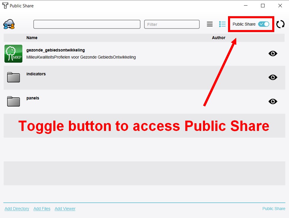
Toggle button to access Public Share.
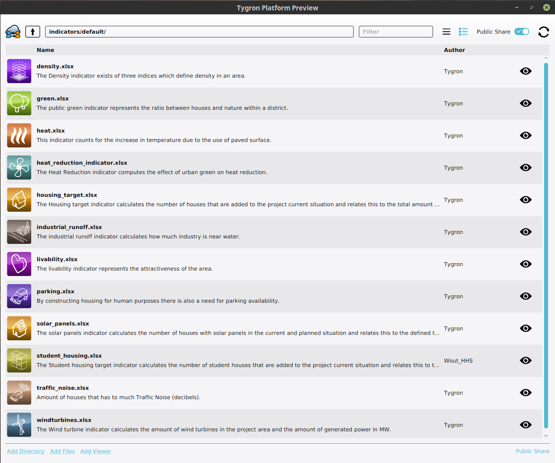
Indicators section on the Public Share


Files
The GeoShare is primarily intended to host geographical data, either for the purpose of standardized input for the creation of Projects, or to host the results of performed calculations in an easily accessible way without the need to keep a Session active or even a complete Project. However, other files can be hosted on the GeoShare as well, with a focus on files which can be used as assets in a Project such as Excels.
The GeoShare supports the following filetypes:
| Filetype | Name | Type of data | Input | Output |
|---|---|---|---|---|
| .cityjson | GeoJSON | 3D visualization data | Import as Custom Geometries for Buildings | |
| .csv | CSV | Text-based list of values | ||
| .docx | Document | |||
| .dxf | DXF | AutoCAD exchange format | Import as Buildings, Areas, etc | |
| .geojson | GeoJSON | 2D Vector data | Import as Buildings, Areas, etc | Export of Vector data |
| .gif | Animated image | Recorded GIF animation | ||
| .gml | XML data | |||
| .jpeg | Image | |||
| .jpg | Image | |||
| .json | GeoJSON | 2D and 3D Vector data | Import as Buildings, Areas, etc | |
| Document | ||||
| .png | Image | Screenshot | ||
| .slpk | SLPK | 3D visualization data | Import as Custom Geometries for Buildings | |
| .tif | GeoTIFF | Grid data | GeoTIFF Overlay, Elevation model, other grid data | |
| .tiff | GeoTIFF | Grid data | GeoTIFF Overlay, Elevation model, other grid data | Export of Grid Overlay |
| .txt | Text | |||
| .xlsx | Excel | Excel | Assets for Indicators, Panels, etc | |
| .xml | XML data |
Viewers
- Main article: GeoShare Viewer
Besides the ability to serve "raw" files, it is possible to create a "viewer" on the GeoShare. Viewers allow for a user-friendly way to share geographical data such as GeoJSONs and GeoTIFFs. They form a type of asset distinctly separate from conventional files and directories. Accessing a viewer in the browser shows a simple web-based interface in which the data of the viewer is visualized. The extent of the viewer is based on the extent of the data which is part of it.
Notes
- The url for any file, directory, or viewer, contains the name of the file and the name of the domain in which the original file was uploaded.
- To reset the access token for any file, disable and re-enable the token for the file. A new token will be generated.
How-to's
- How to create a Geo Plugin to import Areas from the Geo Share at Project creation
- How to load in GeoTIFFs from the GeoShare automatically
- How to create a WFS for data on the GeoShare
Videos

See also
- Geo Plugin: Files with geographical data can be imported directly into a Project automatically via Geo Plugins.
- Indicators on the Public Share
- Panels on the Public Share
- Buildings • Terrains • Administrative • Areas • Networks • Overlays • Indicators • Panels • Globals • Queries • Geo Import
- Buildings
- Function • Function Override • Traffic Units
- Terrain
- Height sector • Elevation model • Elevation GeoTIFF • Elevation Grid Overlay • Ground Price • Terrain Type • Terrain Type Override
- Administrative
- Net Cluster • Net Function • Net Line • Net Load • Net Node • Net Setting
- Editor