Falen keringen template: Difference between revisions
| Line 38: | Line 38: | ||
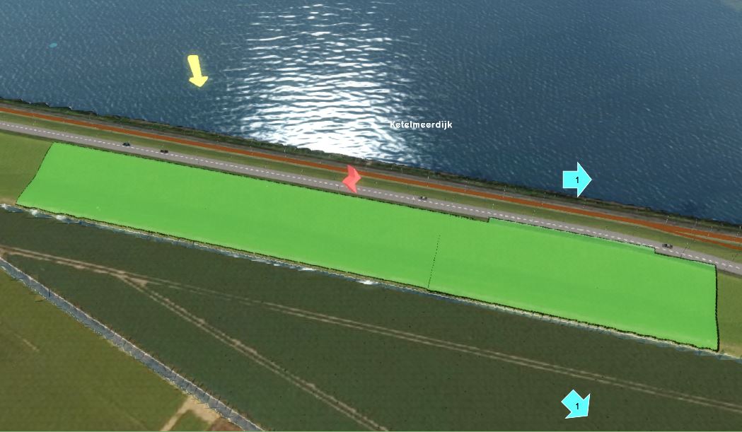
===Bres definiëren=== | ===Bres definiëren=== | ||
{{Editor steps|title= | |||
|[[How to add and remove an Area|Add a new Area]] to the project. This will be the breach area. | |||
|[[How to draw a feature|Draw]] the breach area in the [[3D world]], in the location where the water from the breach should emerge (see tips below in gallery). | |||
|[[How to add and remove an Attribute|Add an Attribute]] to the created [[Area]], with the [[Breach height (Water Overlay)|breach height]] attribute name and a height value. | |||
}} | |||
<gallery mode=nolines> | |||
File:Breach.JPG|It is best to draw the breach area not too close to the water body. Also, the breach area does not have to cover the whole levee, but only the slope of the levee on the side of the area that is going to inundate. | |||
</gallery> | |||
Choose as attribute name for the breach height: Breslocatie_1. | Choose as attribute name for the breach height: Breslocatie_1. | ||
Revision as of 15:53, 9 January 2020
Het falen van keringen is een van de toepassingen van het Tygron Platform. Hiervoor is een template project genaamd Falen keringen template gemaakt. Om dit template effectief in te kunnen zetten is deze handleiding gemaakt. Daarin wordt de te volgen werkwijze beschreven en worden aandachtspunten beschreven.
Vereiste data
- AHN100x100.geojson
- Peilgebieden.geojson
- Duikers_WVS_041219.geojson
- Peilen hoofdsysteem Noord 121219.geojson
Stappen
Hieronder worden de stappen beschrijven om het template project toe te passen op een nieuw gebied tot het exporteren van de resultaten voor verdere analyse.
Template toepassen op nieuw gebied
- Log in op het Tygron Platform; de LTS
- Bekijk de headlines om te zien of er geen storingen, bijvoorbeeld bij het inladen van een bepaalde dataset
- Klik op New Project
- Typ de naam in van het nieuwe project en klik op Use Falen keringen template
- In de volgende stap zoom je naar het gebied waar je een nieuw project van wilt maken op de kaart. Pas desgewenst de grootte van het vierkant/ de rechthoek aan om de grootte van het project aan te passen. Het gedeelte in het vierkant/rechthoek wordt het 3D-model. Klik op de knop Generate map.
- Het nieuwe project wordt nu gegenereerd vanuit de verschillende data bronnen.
Peilgebieden inladen
- Open the Geo_Data_wizard
- Click on next and choose for Areas
- In the next step choose for Import a GeoJSON file and select the file Peilen hoofdsysteem Noord 121219.geojson in the next step
- In step 2, set the slider on 20m to create polygons from the point data.
Peilen hoofdsysteem Noord 121219.geojson als areas. Buffer ze met 20 meter. Maak er een overlay van (tbv peil in external area, zie step 2.1)
Bres definiëren
- Add a new Area to the project. This will be the breach area.
- Draw the breach area in the 3D world, in the location where the water from the breach should emerge (see tips below in gallery).
- Add an Attribute to the created Area, with the breach height attribute name and a height value.
It is best to draw the breach area not too close to the water body. Also, the breach area does not have to cover the whole levee, but only the slope of the levee on the side of the area that is going to inundate.

Choose as attribute name for the breach height: Breslocatie_1.