DXF requirements: Difference between revisions
mNo edit summary |
mNo edit summary |
||
| Line 1: | Line 1: | ||
DX Fis a file format to exchange CAD data from Autodesk. It is the "open" variant of the "closed" DWG format, which is a proprietary binary format. AutoCAD can convert these formats to one another generally without loss of data. This file format can be used to import [[ | DX Fis a file format to exchange CAD data from Autodesk. It is the "open" variant of the "closed" DWG format, which is a proprietary binary format. AutoCAD can convert these formats to one another generally without loss of data. This file format can be used to import 2D [[spatial plan]]s. | ||
==AutoCAD drawing guidelines for importing DXF files into the | ==AutoCAD drawing guidelines for importing DXF files into the {{software}}== | ||
*'''Files should preferably consist of hatches.''' | *'''Files should preferably consist of hatches.''' | ||
| Line 7: | Line 7: | ||
*'''Features in files must be geographic data.''' | *'''Features in files must be geographic data.''' | ||
It is common to add additional information in AutoCAD files for legends, cross-sections, compass roses, etc. These should be left out of the files, or drawn on separate layers that can be ignored/excluded when importing the files, or so far outside the relevant plan area, these are cut off from the imported data. Otherwise, a situation arises where the | It is common to add additional information in AutoCAD files for legends, cross-sections, compass roses, etc. These should be left out of the files, or drawn on separate layers that can be ignored/excluded when importing the files, or so far outside the relevant plan area, these are cut off from the imported data. Otherwise, a situation arises where the {{software}} may process these non-geographical information as if they were geographic objects. | ||
*'''Features in the drawing must have the correct draw order.''' | *'''Features in the drawing must have the correct draw order.''' | ||
The different features must be logically drawn on top of each other. In this case, what you see is what you get. For example, a tree that has been drawn over a garden and can actually be seen in AutoCAD as a tree in the garden will be properly read by the | The different features must be logically drawn on top of each other. In this case, what you see is what you get. For example, a tree that has been drawn over a garden and can actually be seen in AutoCAD as a tree in the garden will be properly read by the {{software}} as one after the other. | ||
This is the draw order determined in AutoCAD. This means that features can certainly overlap provided they come logically one after the other in the drawing. | This is the draw order determined in AutoCAD. This means that features can certainly overlap provided they come logically one after the other in the drawing. | ||
| Line 17: | Line 17: | ||
In short, elements that are on the same level and that may overlap are loaded based on the draw order in AutoCAD. | In short, elements that are on the same level and that may overlap are loaded based on the draw order in AutoCAD. | ||
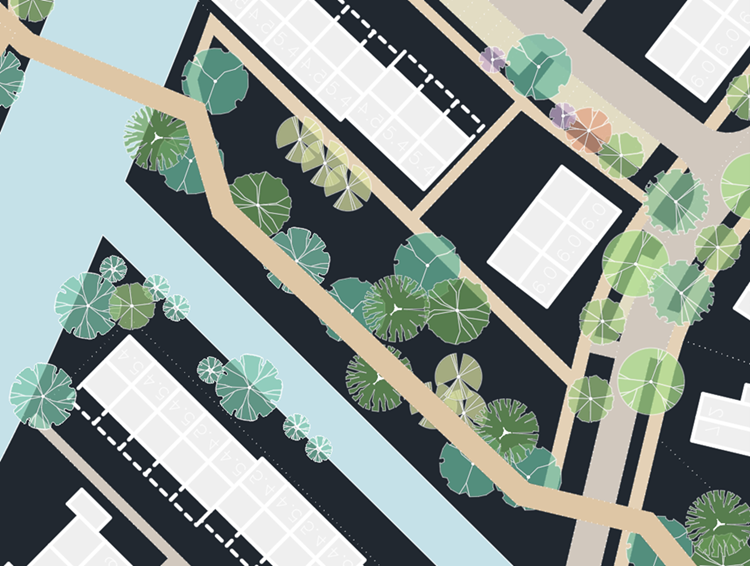
In the drawing below you see an example of a wrong draw order. The road can be seen above the trees. | In the drawing below you see an example of a wrong draw order. The road can be seen above the trees. The {{software}} will load this road after loading the trees, which can cause trees to fall away. A simple solution is to sort the path backwards in AutoCAD. | ||
[[File:CAD Draw Order.png|left|thumb|Example of wrong drawing order]] | [[File:CAD Draw Order.png|left|thumb|Example of wrong drawing order]] | ||
Revision as of 14:09, 8 February 2024
DX Fis a file format to exchange CAD data from Autodesk. It is the "open" variant of the "closed" DWG format, which is a proprietary binary format. AutoCAD can convert these formats to one another generally without loss of data. This file format can be used to import 2D spatial plans.
AutoCAD drawing guidelines for importing DXF files into the Tygron Platform
- Files should preferably consist of hatches.
- Features in files must be geographic data.
It is common to add additional information in AutoCAD files for legends, cross-sections, compass roses, etc. These should be left out of the files, or drawn on separate layers that can be ignored/excluded when importing the files, or so far outside the relevant plan area, these are cut off from the imported data. Otherwise, a situation arises where the Tygron Platform may process these non-geographical information as if they were geographic objects.
- Features in the drawing must have the correct draw order.
The different features must be logically drawn on top of each other. In this case, what you see is what you get. For example, a tree that has been drawn over a garden and can actually be seen in AutoCAD as a tree in the garden will be properly read by the Tygron Platform as one after the other.
This is the draw order determined in AutoCAD. This means that features can certainly overlap provided they come logically one after the other in the drawing.
In short, elements that are on the same level and that may overlap are loaded based on the draw order in AutoCAD.
In the drawing below you see an example of a wrong draw order. The road can be seen above the trees. The Tygron Platform will load this road after loading the trees, which can cause trees to fall away. A simple solution is to sort the path backwards in AutoCAD.
