Density indicators
General
What are the Density indicators?
The Density indicators exists of three indices which define density in an area. These are:
- FSI - Floor Space Index; which gives information about the intensity of the buildings in relation to the open space. The higher the index is, the more buildings and/or floors there are.
- GSI - Ground Space Index; which gives information about the relation between built and open space. The lower the index is, the more open space there is in the area.
- OSR - Open Space Ration; which gives information about the spaciousness and pressure on the open space. An high FSI ensures a low OSR. The higher the OSR is, the more open space there is.
This indicator is useful for projects where for example:
- Density analysis is an important aspect of the project
- a new neighborhood is designed
Indicator panel
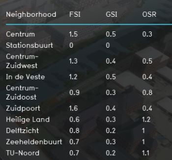
The indicator panel shows per neighborhood:
- the neighborhood name
- FSI score
- GSI score
- OSR score
Calculation
Score
For this indicator no score is being calculated. The progress bar shows always 100% (fixed number).
Additional configurations
For this indicator to function, an extra attribute has to be added to the Neighborhood in where the houses will be build and a new Global has to be defined to set the total housing target. Read below for the steps.
