How to use buffers (TQL): Difference between revisions
No edit summary |
No edit summary |
||
| Line 1: | Line 1: | ||
__NOTOC__ | __NOTOC__ | ||
With the [[TQL | With the [[Buffer (TQL Param)]] clause of [[TQL]], it is possible to retrieve data not just within a specified contour, but in the vicinity of this contour (specified with a distance) as well. | ||
==How buffers are applied== | ==How buffers are applied== | ||
Revision as of 10:31, 28 February 2023
With the Buffer (TQL Param) clause of TQL, it is possible to retrieve data not just within a specified contour, but in the vicinity of this contour (specified with a distance) as well.
How buffers are applied
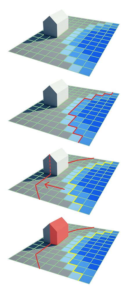
The BUFFER clause affects the polygon selection of the TQL query. When a query makes a selection for, for example, LOTSIZE, the clauses indicate in which selection polygon you want to find the lotsize. The selection polygon is computed by the overlap of clauses such as AREA and MINGRIDVALUE. After this selection polygon is computed, it is queried to find all the relevant lotsizes within.
The buffer is applied after computing the selection polygon, but before finding the lotsize inside the selection polygon. The selection polygon is buffered with the indicated amount to create a larger selection polygon, in which more lotsize may be found.
How to use buffers to retrieve data
Consider a use-case where the amount of green near a neighborhood should be retrieved.
To find the amount of green, the following statement can be created:
SELECT_LOTSIZE_WHERE_FUNCTIONMULT_IS_GREEN_M2
To find the amount of green only in neighborhood 1:
SELECT_LOTSIZE_WHERE_FUNCTIONMULT_IS_GREEN_M2_AND_NEIGHBORHOOD_IS_1
To find the amount of green in neighborhood 1 and in an area of 50 meters around neighborhood 1:
SELECT_LOTSIZE_WHERE_FUNCTIONMULT_IS_GREEN_M2_AND_NEIGHBORHOOD_IS_1_AND_BUFFER_IS_50
How to use buffers to write data
Buffers can also be used in combination with grids to conditionally write data to buildings. For example, consider a use-case where buildings with water nearby should be marked as "threatened".
To find buildings with water on them:
SELECT_LOTSIZE_WHERE_GRID_IS_4_AND_MINGRIDVALUE_IS_0.1*
(*Assuming grid 4 is a Water Overlay's SURFACE_LAST_VALUE result type, and the relevant amount of water is 10cm)
How to write an attribute (THREATENED) to buildings with water on them:
UPDATE_BUILDING_THREATENED_WHERE_GRID_IS_4_AND_MINGRIDVALUE_IS_0.1
How to update buildings with water not just on them, but also within 1 meter of the water:
UPDATE_BUILDING_THREATENED_WHERE_GRID_IS_4_AND_MINGRIDVALUE_IS_0.1_AND_BUFFER_IS_1
Notes
When using buffers, take the following into consideration:
- Buffers only apply to selection polygons. This includes specific polygons, attribute polygons, and grids, but not individual buildings.
- When a buffer clause is used to extend a selection polygon, the new selection polygon includes both the original selection polygon as well as the buffer around it.
- When buffering based on grids, take into account the grid size in respect to the buffer size. If the buffer size is not greater than the grid cell size some vector-based data such as buildings may be less likely to be in range of the grid-based data.
- Buffers cannot be negative. It is not possible to shrink a selection polygon.
- When using a BUFFER clause to create a selection polygon, it is not possible to automatically create an inverse selection. I.e. for a query looking for grid values higher than a certain value and a query looking for grid values lower than that same value, the selection polygons are effective complementary. However, when the queries are buffered, the two selection polygons will overlap.
- By using the LOTPOLYGONS clause in combination with the buffer clause, it is is possible to see the created buffer selection polygon.
