Tygron for Urban Analysis: Difference between revisions
No edit summary |
|||
| (31 intermediate revisions by one other user not shown) | |||
| Line 1: | Line 1: | ||
=Use-case 1: ''“Urban Water Course”'' = | =Use-case 1: ''“Urban Water Course”'' = | ||
For the second year now, [https://www.hvhl.nl/ Van Hall Larenstein] has successfully implemented Tygron in its Water Management specialization, as part of the "Urban Water" HBO course. This university of applied science has collaborated with the [https://www.lelystad.nl/ Municipality of Lelystad] as part of a long-term agreement for maintaining selected | For the second year now, [https://www.hvhl.nl/ Van Hall Larenstein] has successfully implemented the Tygron platform in its Water Management specialization, as part of the "Urban Water" HBO course. This university of applied science has collaborated with the [https://www.lelystad.nl/ Municipality of Lelystad] as part of a long-term agreement for maintaining selected neighbourhoods. For this course, students work in groups to suggest solutions for improving the neighbourhoods livability, climate and water systems. They do that by modelling the neighbourhoods using the Tygron platform and running different stress tests. The working groups should also consider [https://www.avecodebondt.nl/ Aveco de Bondt] and the water board [https://www.zuiderzeeland.nl/ Zuiderzeeland] as clients, in addition to the municipality. Last year (2020) the second part of the course was conducted online, of course with many challenges due to the sudden shift to online learning. However, this year (2021), the students attended the entire course from home. | ||
==Content of the course== | ==Content of the course== | ||
| Line 11: | Line 11: | ||
*'''Study Programme''': [https://www.hvhl.nl/studeren/opleidingen/bachelor/Land+en+watermanagement/studieprogramma.html Land and Water Management] | *'''Study Programme''': [https://www.hvhl.nl/studeren/opleidingen/bachelor/Land+en+watermanagement/studieprogramma.html Land and Water Management] | ||
*'''Educational Institute''': Van Hall Larenstein University of Applied Sciences | *'''Educational Institute''': [https://www.hvhl.nl/ Van Hall Larenstein University of Applied Sciences] | ||
===Target students=== | ===Target students=== | ||
*The students taking this course are at an HBO level (Bachelor level). | *The students taking this course are at an HBO level (Bachelor level). | ||
*The students are expected to have prior knowledge of GIS, CAD, Hydrodynamic | *The students are expected to have prior knowledge of GIS, CAD, Hydrodynamic Modelling, and SOBEK 2 & 3. | ||
*The students do not have any prior knowledge of Tygron. | *The students do not have any prior knowledge of Tygron. | ||
===Objectives and desired outcome=== | ===Objectives and desired outcome=== | ||
This course focuses on the sustainable design of an urban area using vulnerability assessment, | This course focuses on the sustainable design of an urban area using vulnerability assessment, modelling and solution recommendation. | ||
The main learning objectives are to: | The main learning objectives are to: | ||
| Line 32: | Line 32: | ||
#An individual 'reference study' to provide insight into sustainable solutions for climate issues, focusing on urban water management. | #An individual 'reference study' to provide insight into sustainable solutions for climate issues, focusing on urban water management. | ||
#A 'model using Tygron', showing the current situation of the selected area, as well as potential sustainability solutions. | #A 'model using Tygron', showing the current situation of the selected area, as well as potential sustainability solutions. | ||
#An individual ' | #An individual 'StoryMap' showcasing the challenges of the area, the vulnerabilities as well as the proposed solutions and their effects. | ||
==Design of the Course== | ==Design of the Course== | ||
===Syllabus and time distribution=== | ===Syllabus and time distribution=== | ||
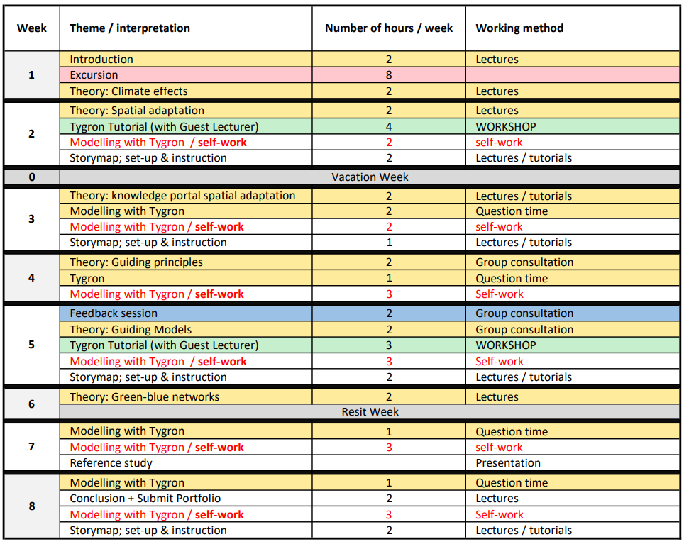
The course is delivered in Dutch and is spread over | [[File:Schedule urban water.png|thumb|250px|right|Schedule of the urban water course.]] | ||
The course is delivered in Dutch and is spread over 8 weeks, with an average of 5-7 hours per week, with an additional exam week (week 9). | |||
The following steps explain how the course goes: | The following steps explain how the course goes: | ||
#The assignment is briefly introduced. | #The assignment is briefly introduced. | ||
#An excursion to the municipality is organized. During the | #An excursion to the municipality is organized. During the COVID-19 lock-down, students went on a digital virtual excursion. | ||
#Then students choose a topic for the reference-study (individually). For example, it could be a specific technology / measure / instrument, a special approach / process or a specific exemplary street or | #Then students choose a topic for the reference-study (individually). For example, it could be a specific technology / measure / instrument, a special approach / process or a specific exemplary street or neighbourhood in the country. | ||
#Instructors deliver an average of 2 hours/week of theory lectures about:''Climate effects / Spatial adaptation / National Adaptation Strategy / Guide principle and guide models / Green-blue networks climate effects'' | #Instructors deliver an average of 2 hours/week of theory lectures about:''Climate effects / Spatial adaptation / National Adaptation Strategy / Guide principle and guide models / Green-blue networks climate effects'' | ||
#A guest lecturer provides 2 hands-on workshops about | #A guest lecturer provides 2 hands-on workshops about Modelling with the Tygron platform. These tutorials take place in weeks 2 and 5. | ||
#Students also learn how to create StoryMaps with tutorials (around 1 hour per week) | #Students also learn how to create StoryMaps with tutorials (around 1 hour per week) | ||
#While learning Tygron, students form themselves into groups of 3 (6 groups) to model their selected area. For that they have to: | #While learning Tygron, students form themselves into groups of 3 (6 groups) to model their selected area. For that they have to: | ||
| Line 52: | Line 52: | ||
#*Calculate the effectiveness of measures. | #*Calculate the effectiveness of measures. | ||
#*Reflect critically on model assumptions. | #*Reflect critically on model assumptions. | ||
#The students present their reference-study through a 10-minute-digital presentation in week 7. | |||
#Students are given around 2 -3 hours per week for self-study | #Students are given around 2 -3 hours per week for self-study | ||
#Students are also given continuous support using question-sessions, online consultation and feedback sessions. | #Students are also given continuous support using question-sessions, online consultation and feedback sessions. | ||
#At the end of the course, students have to individually showcase | #At the end of the course, students have to individually showcase the stress tests and proposed solutions using StoryMaps. | ||
===Guidance and | <u>You can find the complete course handbook here:[[File: Course_Handbook_Urban_Water.pdf]]</u> | ||
===Guidance and resources=== | |||
====Lectures and assignments==== | |||
*There are two instructors who guide the students through this course by providing lectures, counselling and feedback. | |||
*Throughout the course, students work in groups of 3 or 4 on a ''case study'' in Lelystad. | |||
*Each group is assigned a neighbourhood with an area of a maximum of 1000 x 1000 meters. | |||
*Each neighbourhood has its own social and environmental issues that students should focus on. | |||
====Modelling with the Tygron Platform==== | |||
*Two hands-on workshops are organized with a guest lecturer from Aveco de Bondt to guide the students on how to use the Tygron platform. | |||
*Students use their own laptops to create their models. | |||
*Students refer back to Tygron's wiki while creating their models. | |||
*The instructors have some experience with the Tygron platform. | |||
====Other tools==== | |||
*Students learn how to use [https://storymaps.arcgis.com/ ArcGIS StoryMaps] during this course. | |||
*Students are also introduced to the spatial adaptation portal [https://klimaatadaptatienederland.nl/ Ruimtelijke Adaptatie] as a major source of information. | |||
==Outcome and Assessment== | ==Outcome and Assessment== | ||
===Outcomes of the course=== | |||
The urban water course is concluded with a portfolio. | |||
The portfolio consists of: | |||
#an individual reference study | |||
#a group model of the planning area | |||
#a StoryMap that includes the following: | |||
#*The characteristics and municipal goals with regard to safety, quality of the living environment, sustainability and efficiency. | |||
#*Climate effects and vulnerabilities in the area (flooding, drought, heat stress, etc.). | |||
#*Solutions and proposed measures to improve climate robustness, quality of life, and sustainability of the district. | |||
#*Recommendations for the technical, financial and organizational feasibility. | |||
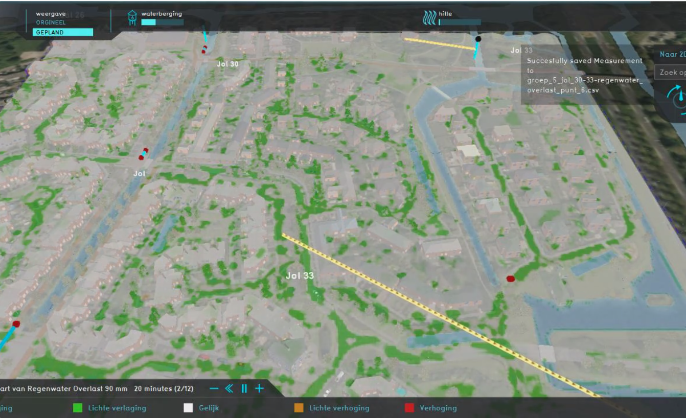
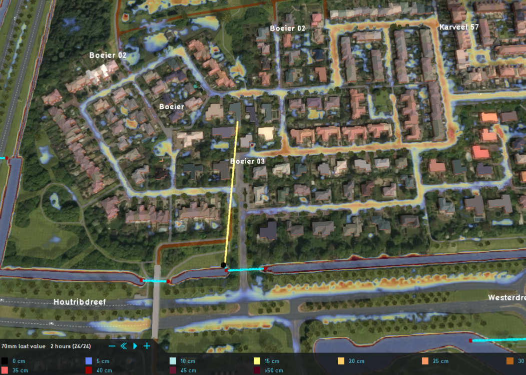
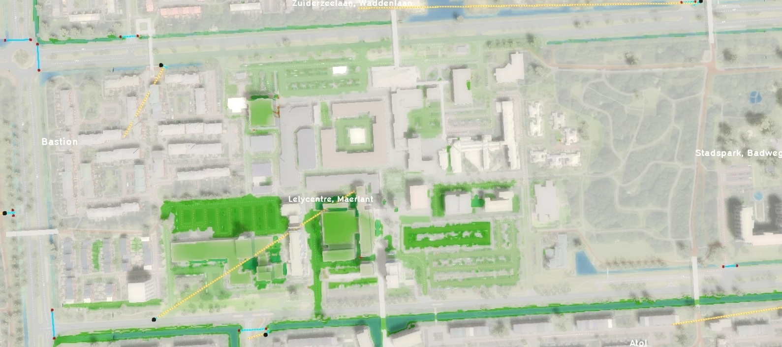
Below are some examples of the StoryMaps that students produced last year (April 2020): | |||
<gallery " mode="packed-overlay" heights=250px> | |||
File:jol.png|[https://storymaps.arcgis.com/stories/386837c260fd4c3cbf33506fea6ea618 StoryMap: Jol 30-33, Lelystad] | |||
File:boeier.png|[https://storymaps.arcgis.com/stories/cc45904b2bba4e6c8c8409f23b8954e5 StoryMap: De Boeier, Lelystad] | |||
File:lelycenter.png|[https://storymaps.arcgis.com/stories/c996ea99e44443e0b891a13327538c2e StoryMap: Lelycentre, Lelystad] | |||
</gallery> | |||
<u>'''You can find the link to all last year's StoryMaps here: [[File:STORYMAPS_Lelystad.pdf]]'''</u> | |||
===Assessment=== | |||
*The assessment rubric is based on the 5 different learning objectives, with 20% for each. | |||
*The reference study is assessed separately in week 7 through a digital presentation. The presentations are assessed by the teacher and the students taking into account the following criteria | |||
*#Broad perspective | |||
*#State-of-the-art | |||
*#Content / technical elaboration | |||
*#Requirements | |||
*The modelling and the StoryMaps are assessed orally (80%). | |||
The rubric table below explains how the outcomes relate to the learning objectives: | |||
{| class="wikitable" | |||
|+ Rubric for Urban Water | |||
|- | |||
! style="width: 150pt;" |Learning objective | |||
! style="width: 70pt;" |Type of assessment | |||
! style="width: 30pt;" |% | |||
! style="width: 50pt;" |1 | |||
! style="width: 50pt;" |2 | |||
! style="width: 350pt;" |3 | |||
! style="width: 200pt;" |4 | |||
|- | |||
| 1. Assess vulnerability to the effects of climate change | |||
| Oral assessment | |||
| 20% | |||
| No or irrelevant answers | |||
| Incomplete answers | |||
| | |||
*Names several relevant climate effects. | |||
*Knows roughly how to determine climate effects. | |||
*Discusses the consequences for various sectors. | |||
| | |||
*Linked to practice | |||
*Detailed | |||
*Clear and complete substantiation | |||
*Reflective ability | |||
|- | |||
| 2. Modelling an urban water system | |||
| Oral assessment | |||
| 20% | |||
| No or irrelevant answers | |||
| Incomplete answers | |||
| | |||
*Create a working model . | |||
*Validate the model. | |||
*Calculate the effectiveness of measures. | |||
*Reflect critically on the model assumptions made. | |||
| | |||
*User-friendly | |||
*Detailed | |||
*Structured | |||
|- | |||
| 3. Develop a vision for sustainable area design | |||
| Oral assessment | |||
| 20% | |||
| No or irrelevant answers | |||
| Incomplete answers | |||
| | |||
*Familiar with common guiding principles for sustainable area design. | |||
*Can make some links between urban water and sustainable area development, including the triad of nuisance, nuisance and damage | |||
| | |||
*Clear and complete substantiation | |||
*Clear accountability for choices | |||
*Strategic view | |||
*Clear target group orientation | |||
|- | |||
| 4. Efficient use of digital resources for advice on sustainable design | |||
| Oral assessment | |||
| 20% | |||
| No or irrelevant answers | |||
| Incomplete answers | |||
| | |||
*A clear presentation with digital support and a working StoryMap . | |||
| | |||
*Target group oriented | |||
*Professional appearance | |||
*Innovative | |||
|- | |||
| 5. Determining sustainable solutions for climate issues | |||
| Reference study presentation | |||
| 20% | |||
| No or irrelevant information | |||
| Incomplete information | |||
| | |||
*State-of-the-art (experiences / examples) of sustainable innovation clearly emerges. | |||
*Strong points (qualities) and points for attention are discussed. | |||
*A link is made with the relevant context (spatial, legal, technical, socio-economic and / or organizational) | |||
| | |||
*Clearly detailed | |||
*Nuanced / critical | |||
*Detailed / complete | |||
|} | |||
==Feedback and recommendations== | ==Feedback and recommendations== | ||
According to the instructors of this course, these are the most relevant challenges: | |||
*Last year, the institute had to switch to online classes due to the lock-down. This shift had a negative impact on the course and the outcome of the students. However, this year everyone is more comfortable working from home. | |||
*Having a large number of students could be problematic. Last year (2020), there were 30 students attending the course. | |||
*There was a large gap in performance among students. Some students had to resubmit the portfolio. | |||
*Students find it difficult to learn and work with new software. This was more evident last year especially that students started very late with their assignments. | |||
Based on the experience with the course, the instructors recommend: | |||
# Working on a real project and including real clients and stakeholders. | |||
# Organizing an excursion to the location of the planning area where students can understand the site and meet stakeholders. | |||
# Having a smaller group of students in the course (around 15-17 students). | |||
# Continuous support for students when they are working with the Tygron platform. | |||
# Supplementing the students with theory and relevant tools. | |||
# Including self-study in the schedule. | |||
# Having a mix of individual and group assessments. | |||
# Preferably, not doing everything online because many technical problems could occur with the working groups. | |||
# Instructors should be able to learn the Tygron platform and prepare the tutorials themselves. | |||
# Reaching out to Tygron's help desk if any problems occur. | |||
==Contact== | |||
For more information about this course, you can contact us at: {{email}} | |||
You can also reach the coordinator of this course: [https://nl.linkedin.com/in/anouk-berendsen-sloot-000a7921 Anouk Berendsen-Sloot ], Water teacher (Land and Water Management), Van Hall Larenstein: {{email|anouk.berendsen|hvhl.nl}} | |||
{|class="wikitable" style="margin: auto; background-color:#ffffcc;" | |||
| [[Tygron EDU Manual|<<Previous page]] | |||
| [[Tygron for GIS Data|Next page>>]] | |||
|} | |||
Latest revision as of 14:25, 22 September 2023
Use-case 1: “Urban Water Course”
For the second year now, Van Hall Larenstein has successfully implemented the Tygron platform in its Water Management specialization, as part of the "Urban Water" HBO course. This university of applied science has collaborated with the Municipality of Lelystad as part of a long-term agreement for maintaining selected neighbourhoods. For this course, students work in groups to suggest solutions for improving the neighbourhoods livability, climate and water systems. They do that by modelling the neighbourhoods using the Tygron platform and running different stress tests. The working groups should also consider Aveco de Bondt and the water board Zuiderzeeland as clients, in addition to the municipality. Last year (2020) the second part of the course was conducted online, of course with many challenges due to the sudden shift to online learning. However, this year (2021), the students attended the entire course from home.
Content of the course
General information
- Name of the course: "Urban Water"
- Study-block: "Water Management"
- Study Programme: Land and Water Management
- Educational Institute: Van Hall Larenstein University of Applied Sciences
Target students
- The students taking this course are at an HBO level (Bachelor level).
- The students are expected to have prior knowledge of GIS, CAD, Hydrodynamic Modelling, and SOBEK 2 & 3.
- The students do not have any prior knowledge of Tygron.
Objectives and desired outcome
This course focuses on the sustainable design of an urban area using vulnerability assessment, modelling and solution recommendation.
The main learning objectives are to:
- Assess vulnerability to the effects of climate change
- Model an urban water system
- Develop a vision for sustainable urban design
- Use digital resources efficiently to recommend actions for sustainable design
- Determine sustainable solutions for climate issues
To reach the above learning objectives, students are expected to produce the following outcomes:
- An individual 'reference study' to provide insight into sustainable solutions for climate issues, focusing on urban water management.
- A 'model using Tygron', showing the current situation of the selected area, as well as potential sustainability solutions.
- An individual 'StoryMap' showcasing the challenges of the area, the vulnerabilities as well as the proposed solutions and their effects.
Design of the Course
Syllabus and time distribution
The course is delivered in Dutch and is spread over 8 weeks, with an average of 5-7 hours per week, with an additional exam week (week 9).
The following steps explain how the course goes:
- The assignment is briefly introduced.
- An excursion to the municipality is organized. During the COVID-19 lock-down, students went on a digital virtual excursion.
- Then students choose a topic for the reference-study (individually). For example, it could be a specific technology / measure / instrument, a special approach / process or a specific exemplary street or neighbourhood in the country.
- Instructors deliver an average of 2 hours/week of theory lectures about:Climate effects / Spatial adaptation / National Adaptation Strategy / Guide principle and guide models / Green-blue networks climate effects
- A guest lecturer provides 2 hands-on workshops about Modelling with the Tygron platform. These tutorials take place in weeks 2 and 5.
- Students also learn how to create StoryMaps with tutorials (around 1 hour per week)
- While learning Tygron, students form themselves into groups of 3 (6 groups) to model their selected area. For that they have to:
- Create a working model.
- Validate the model.
- Calculate the effectiveness of measures.
- Reflect critically on model assumptions.
- The students present their reference-study through a 10-minute-digital presentation in week 7.
- Students are given around 2 -3 hours per week for self-study
- Students are also given continuous support using question-sessions, online consultation and feedback sessions.
- At the end of the course, students have to individually showcase the stress tests and proposed solutions using StoryMaps.
You can find the complete course handbook here:File:Course Handbook Urban Water.pdf
Guidance and resources
Lectures and assignments
- There are two instructors who guide the students through this course by providing lectures, counselling and feedback.
- Throughout the course, students work in groups of 3 or 4 on a case study in Lelystad.
- Each group is assigned a neighbourhood with an area of a maximum of 1000 x 1000 meters.
- Each neighbourhood has its own social and environmental issues that students should focus on.
Modelling with the Tygron Platform
- Two hands-on workshops are organized with a guest lecturer from Aveco de Bondt to guide the students on how to use the Tygron platform.
- Students use their own laptops to create their models.
- Students refer back to Tygron's wiki while creating their models.
- The instructors have some experience with the Tygron platform.
Other tools
- Students learn how to use ArcGIS StoryMaps during this course.
- Students are also introduced to the spatial adaptation portal Ruimtelijke Adaptatie as a major source of information.
Outcome and Assessment
Outcomes of the course
The urban water course is concluded with a portfolio. The portfolio consists of:
- an individual reference study
- a group model of the planning area
- a StoryMap that includes the following:
- The characteristics and municipal goals with regard to safety, quality of the living environment, sustainability and efficiency.
- Climate effects and vulnerabilities in the area (flooding, drought, heat stress, etc.).
- Solutions and proposed measures to improve climate robustness, quality of life, and sustainability of the district.
- Recommendations for the technical, financial and organizational feasibility.
Below are some examples of the StoryMaps that students produced last year (April 2020):
You can find the link to all last year's StoryMaps here: File:STORYMAPS Lelystad.pdf
Assessment
- The assessment rubric is based on the 5 different learning objectives, with 20% for each.
- The reference study is assessed separately in week 7 through a digital presentation. The presentations are assessed by the teacher and the students taking into account the following criteria
- Broad perspective
- State-of-the-art
- Content / technical elaboration
- Requirements
- The modelling and the StoryMaps are assessed orally (80%).
The rubric table below explains how the outcomes relate to the learning objectives:
| Learning objective | Type of assessment | % | 1 | 2 | 3 | 4 |
|---|---|---|---|---|---|---|
| 1. Assess vulnerability to the effects of climate change | Oral assessment | 20% | No or irrelevant answers | Incomplete answers |
|
|
| 2. Modelling an urban water system | Oral assessment | 20% | No or irrelevant answers | Incomplete answers |
|
|
| 3. Develop a vision for sustainable area design | Oral assessment | 20% | No or irrelevant answers | Incomplete answers |
|
|
| 4. Efficient use of digital resources for advice on sustainable design | Oral assessment | 20% | No or irrelevant answers | Incomplete answers |
|
|
| 5. Determining sustainable solutions for climate issues | Reference study presentation | 20% | No or irrelevant information | Incomplete information |
|
|
Feedback and recommendations
According to the instructors of this course, these are the most relevant challenges:
- Last year, the institute had to switch to online classes due to the lock-down. This shift had a negative impact on the course and the outcome of the students. However, this year everyone is more comfortable working from home.
- Having a large number of students could be problematic. Last year (2020), there were 30 students attending the course.
- There was a large gap in performance among students. Some students had to resubmit the portfolio.
- Students find it difficult to learn and work with new software. This was more evident last year especially that students started very late with their assignments.
Based on the experience with the course, the instructors recommend:
- Working on a real project and including real clients and stakeholders.
- Organizing an excursion to the location of the planning area where students can understand the site and meet stakeholders.
- Having a smaller group of students in the course (around 15-17 students).
- Continuous support for students when they are working with the Tygron platform.
- Supplementing the students with theory and relevant tools.
- Including self-study in the schedule.
- Having a mix of individual and group assessments.
- Preferably, not doing everything online because many technical problems could occur with the working groups.
- Instructors should be able to learn the Tygron platform and prepare the tutorials themselves.
- Reaching out to Tygron's help desk if any problems occur.
Contact
For more information about this course, you can contact us at:
You can also reach the coordinator of this course: Anouk Berendsen-Sloot , Water teacher (Land and Water Management), Van Hall Larenstein:
| <<Previous page | Next page>> |


